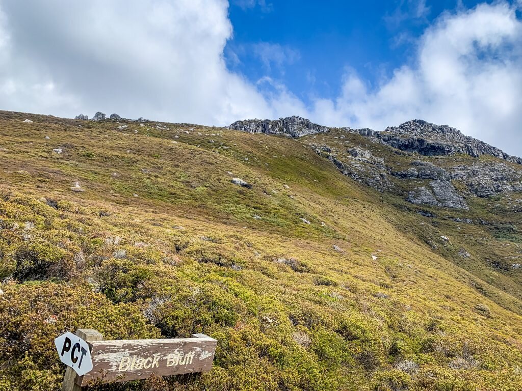
Black Bluff Range
Date: 4th November 2019 – Summit: 1340+

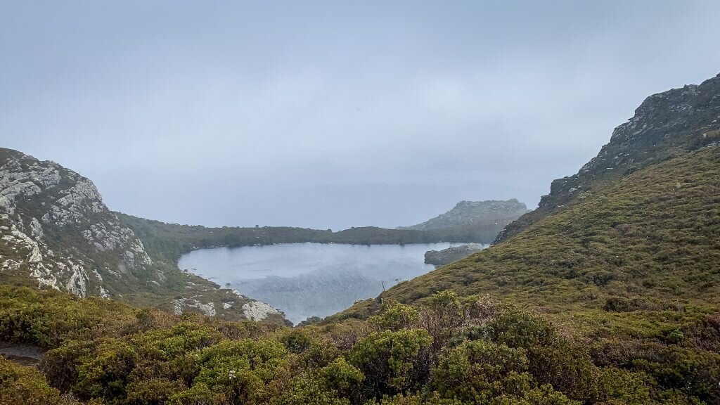
Paddys Lake in the sunlight on my return journey.
With only one day for walking up my sleeve I decided to check out Black Bluff Range. A solo adventure today - because girls can adventure just as well as boys. There is something about being totally reliant on yourself in challenging conditions that’s both exciting and nerve racking! I put it out to the weather gods to look after me as Black Bluff Range is notorious for screaming winds and white outs turning many an adventurer back at the trig! But being an Abel purist my mountain needed that extra 2km and 1m of elevation, and of course to lay my hands on the summit cairn.

The PCT signpost alongside the Balck Bluff signpost at the start of the trail.

The spacious track leading through the trees towards the river.
As I would be hiking alone I had made sure I was (extra) well prepared the night before. I had memorised my route for the untracked section, pre-marked out compass bearings and packed all manner of gear in my running vest. Viewing pictures on a local hiking page the day before of freezing cold, white out conditions at the trig had ensured my trusty thermals and outer layers were stashed in my pack and well as my PLB. I pondered taking my snow goggles but thought "surely I won't need those".... famous last words!
A little after two hours from leaving home, I was geared up and stepping foot on the Penguin Cradle Trail (PCT) at the grassy picnic area by the River Leven, off Taylors Flats Road. The sign stating you are on the Black Bluff Trail also has a hand painted addition below it advising one to "follow markers ALONG the river - DON'T go through the poplars". I am glad I noticed the addition as it appears many a hiker goes off the trail accidentally not far after beginning. As the poplars thin the trail becomes marked with tape and reflectors and can only be described as spacious! I could have linked arms with 15 friends and still had room on the trail! Wide, well padded and obviously well used. I wondered if the trail had always been so spacious, or whether walkers had gradually over time encroached on the bush either side of the original track - I suspect the latter.

Pretty and spacious are two words that best describe the beginning of the trail.

Reflectors are frequent on the initial sections of trail.

A very small creek crossing indicates the change in elevation.
Initially walking was flat and pretty all the time winding along through the tall tea tree. After following the path for less than five minutes I arrived at the junction to turn towards the river. There was a pad forming through the poplars and tea tree where obviously walkers had missed seeing the advice signposted at the start of the trail. The path now swept off to the right and hugged the river popping in and out of the canopy before reaching a small creek crossing.

The climb starts.

Elevation increases more quickly from this point but the trail is obvious and roomy!
Here the rise began in earnest. Having climbed both Drys Bluff and Clumner Bluff in recent days I certainly couldn't say that Black Bluff Range was steep in comparison, but it does have a fairly steady and consistent increase in gradient. The path was muddy after heavy recent rains, but so well frequented and roomy that hiking was easy going! Only in the very upper reaches of the track towards Paddys Lake would I find any plants encroaching on my feet and legs. The sun was trying its best to shine for me but the morning was cool. Perfect hiking weather - if only it had remained that way!
I received my first good glimpse of the skyline about 40 minutes after starting, not a great view but enough to spur me on. The clouds above me looked to be clearing and the sun was shinning ever so slightly. Underfoot was now less softly padded and more rocky. As I continued higher there were some small areas where bauera was encroaching on the path. The weather was changing from sunlight to drizzle and then back again frequently and the wind was increasing. With each step towards Paddys Lake, the weather was deteriorating, not a good omen for summiting today but in the relative shelter of the forest canopy I was lulled into a false sense of weather calm!

Vegetation beginning to encroach on the track.

The goal for the day!

Breaking in and out of the tree line. This section of track encroaches onto the track.
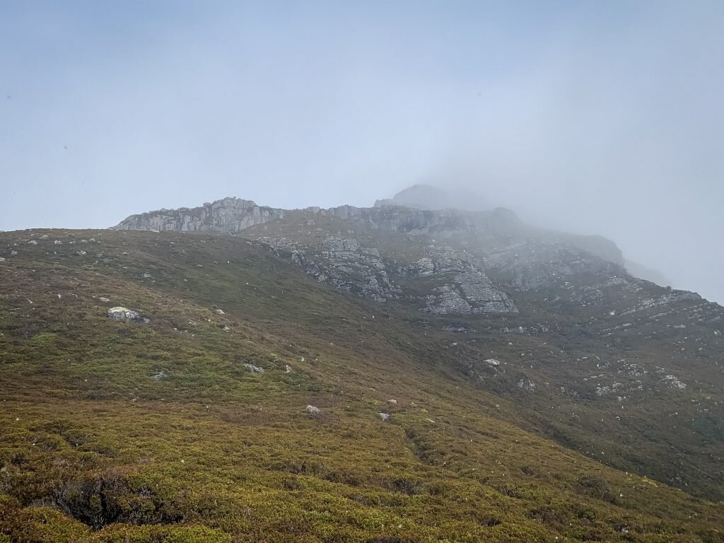
Breaking out of the trees I saw (and I use that term loosely) my goal for the day - Black Bluff. By saw, it I mean glimpsed it for a fraction of a second before it was swallowed again by thick mist. Great! At least I knew I wasn't far from Paddys Lake as my watch was reading around 5km. The ground underfoot had changed almost entirely to rocky creek bed with vegetation encroaching fully on the track in small areas and water running through my feet at times ankle height, probably snow melt mixed with the day's rain. Cresting the ridge before dropping down towards Paddys Lake, the track split into two. No markers indicated which path to use. After having a look at both I took the path veering to the right as it clearly saw more use. It was the correct decision.

Looking back on the rocky tors (this photo taken on my return journey as the weather on the hike in was so bad).

The ridgeline leading towards the trig hidden behind the visible rock face.

The track opening out by Paddys Lake.

The red track sign indicating the walker to contour around the lake.
Now surrounded by low alpine heath affording me uninterrupted views of Black Bluff off to my west, and some small rocky tors off to my east, I rounded the last bend and was presented with the spectacular Paddys Lake. I have seen so many pictures of Paddys Lake and none of them do it justice. After walking for just shy of 1.5 hours I was pleased with my progress and the rain had stopped and mist lifted. How lucky am I? I was thinking. Less than 5 minutes later Black Bluff showed her true colours and in every way attempted to force me homewards before reaching my goal!
Black Bluff hiding behind the mist.
No sooner had I snapped a few pictures of the lake, I felt an instant and freezing chill hit the air, like shivers-down-your-back chill. The sky immediately darkened and the wind suddenly came howling around the lake, covering Black Bluff with a thick, white mist. I could no longer see the mountain. Worse still, the roaring winds bought with them hail and snow. The hail was so intense, so hard that it was hitting my face and causing a burning sensation on my skin. I couldn't lift my head as it was blowing directly at me and each time I tried to lift my head my eyes would get pelted with hail, or my throat would burn with the accompanying cold winds. My goal of reaching the summit was slipping away and I doubted I would even make the trig. Why hadn't I packed my snow goggles? I took a few minutes to use a bulldog clip (I always keep one stashed on my pack) to cinch in the hood on my jacket, effectively creating a face cover all the while cursing; less than lady-like language was being directed at the weather gods. It took all my body weight to lean into and fight against the winds and hail to make any progress.
What was clear a few minutes earlier rapidly was swallowed by mist.
After a quick mental inventory of my pack reassuring myself I had enough wet weather and warm gear to keep me out of trouble, enough food for an emergency overnight bunk out if necessary, and a map and compass if I lost total visibility, I decided to try to push on for the trig point at least. Contouring up and around the lake I was conscious of not missing the turn off from the PCT to Black Bluff in the hail. Mind you, if I had missed the turn off I could have ascended to the summit direct from the PCT instead. Even with the weather screaming at me and no real visibility I reminded myself that it was Tasmania and as such the weather could change for the better - or worse, whilst at the same time thinking my parents would kill me if they could see the conditions I was out in and where I was... (Sorry Mum!)

The climb up towards the trig.

Climbing upwards the track is well visible.
The climb up the branch of the track to Black Bluff off the PCT is steep in places. No getting around it. I would be lying if I said I was enjoying that section - hail hitting my face, steep climbing, cold mist surrounding me and no views above or below me - yuk! But fortune favours the brave and after climbing the track for a few more minutes the sun returned and someone turned the tap off on the hail! I could see below me the love-heart shaped Paddys Lake. No views of Black Bluff as it was still shrouded in mist, but I would take what I could get! It was eerie climbing upwards into nothing but white. Looking down at my feet, I could see the track but lift my head and look upwards nothing but white. I knew the Black Bluff trig was up there somewhere though.

Cairn markers.
With relief I stepped out onto the more level section of track sheltered between the two rocky sides of Black Bluff. Cairns now indicated the way to continue, but I at least had some level of visibility back as the mist wasn't settled down in the small valley. Here, for the first time I caught a glimpse of the Trig - or at least could see its outline in the white surrounding it. Yay! I would make the trig!

No view but we will take it anyway!

The Trig

Somewhere out there is the true summit!
A short scramble up the rocky outcrop that holds the trig and my first goal for the day was accomplished in under 2 hours. It is amazing how horrendous weather gets you moving fast! Decision time - to push on and try to make the true summit or not? I assessed the situation and decided to push on. I was still relatively warm and dry and had back up warm and dry layers in my pack. Check. I had heaps of food. Check. I had enough daylight hours left. Check. I had pre-marked compass bearings and rough distance calculations. Check. I had a PLB if things went horribly pear shaped. Check. With all of the safety considerations covered limited visibility wasn't an issue, neither was snow. I will admit its a weird feeling being daunted and excited at the same time. NOTE: Unless you are confident in navigation (and have GPS/Compass/Map etc.) do not attempt to make the summit in poor weather or low visibility.
From prior research and study of The Abels book I was aware that the final untracked section covered a descent down a boulder field with alpine heath, crosses a creek, hits an alpine moor and then according to my map climbs gently again to a group of rocks that mark the highest point. I also had a photo of the summit cairn. I couldn't see more than twenty feet in front of me at this stage. Pulling out my map for the first time today I set my compass, pointed it into the misty white never-never and started off.

Hidden behind the next rise is the elusive summit
Descending the initial boulders was tricky in the sight-stealing mist and given hail was again falling heavily they were more than a touch slippery. A fair amount of that descent was performed on my backside! I assumed that would be the real work but alas the real challenge started at the base of the large boulders where the boulder-strewn slope was mixed with alpine heath. Gaps between the boulders hidden by alpine heath were a sprained ankle waiting to happen. It was relatively slow progress until I was standing below the western slopes with their snow patched sections.

Heavy snow falling and now distant visibility.

Snow littering the final climb.
Stepping out onto the top of the first slope I was presented with another smaller slope behind which was a blanket of mist but I thought I could see faint shadows behind it. I re-checked my bearings and distance and knew I still had at least 1km before I would be in the vicinity of searching for the cairn. Even though the mountain slope in the distance was still hidden the mist directly around me had lifted and I put a call out to the universe for sunlight!
Cresting the final western slope I spied the rocky outcrops that The Abels book refers to! Oh my I might just summit today! And I might even get a view if the weather would just lift. Less than 500m to go and I was elated, what could go wrong now? Ha! The weather gods gave me one final slap in the face lifting the winds and returning the hail. I was hiking towards the rocky outcrops whilst screeching at the mountain and the weather!

A beautiful sight in the distance there! The summit cairn!

Sun shinning of the days goal!

Totally weather beaten. Snow, hail, winds, rain but I made it!

The rocky outcrop that holds the summit cairn.
Perhaps it was my tantrum, perhaps it was just my perseverance but as I approached the final rocky outcrop with the summit cairn in view the sun shone again, the clouds cleared and I felt real warmth hit my face for the first time that day. A little rock scramble and my hand was placed on the precious pile of rocks that marks the summit - all of that for 1m extra of elevation but it felt so sweet! My second solo Abel in the bag and well and truly earned in the conditions.

Finally some sunlight, some views and some warmth.

Sunlight on the way home allowed for beautiful views.

What was invisible before is visible now.

Snow slippery slides made the return journey fun.
Relaxing back on the summit rocks I enjoyed a wind exposed but sunny snack. A coffee would have gone down a treat but I would have to settle with cake instead! In the warmth of the sun I was tempted to relax for a bit but the weather could not be trusted. I chose instead to make my way back.
From the summit my original plan had been to drop directly back down onto the PCT so as to see the track back to Paddys Lake from a different route. If I was to climb Black Bluff Range again I would merely follow the PCT until directly opposite the rocky outcrops holding the summit cairn and then bee-line it from the PCT to the summit. It would make a quicker ascent, that said you would miss seeing the Trig which, in better weather at least, offers the more spectacular views. But I decided to retrace my footsteps to see the Trig views in better weather.
Wandering slowly back to the trig I had some fun sliding down the snow on my backside. I was in no hurry so it was nice to have a play and explore. With the skies now clearer I could actually see the trig for most of the return journey... mind you I had compass bearings set, in case the mist swallowed it up.

The circular shelter opposite the trig.

Looking across to where the PCT leads off eventually passing the point where you can b-line the summit instead of going via the trig.
Returning to the trig in cold but clear conditions allowed me time to look around the Trig area. I particularly like the small, rounded shelter opposite the Trig as it reminded me a little of a beehive cairn, it was invisible in the mist earlier in the day. Sitting in the sun at the high camp area near the trig eating a sandwich I reflected on how the weather can change constantly up here.
After a delicious sandwich I decided to head back to the car, take some extra photos as the weather was more agreeable and enjoy an early drive home. I was wishing I had trail shoes on for the descent as the trail would make a beautiful, albeit technical trail run.
The homewards journey with clear skies affordable beautiful views.
The stats.
Distance: Approx. 18.5 km out-and-back.
Time taken: About 6 hrs, including numerous quick stops and a short lunch.
Difficulty: Easy to the trig point and then moderate from the trig to the summit as it is untracked from there.
Type of track: Well tracked and marked to the trig and then completely untracked to the summit approx 2km away.
Access from: Access off Taylors Flats Road.
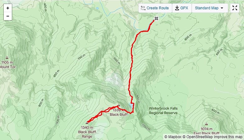
Route to Black Bluff Range via Paddys Lake.