Clear Hill
30th May 2021 Summit: 1198m

Views from Clear Hill to the Gordon River below. Photo Credit with thanks to Ben Young.
It was time for a walk and my friends and I didn't have the luxury of time for a multi-day trip. Instead, we needed a walk we could achieve on a short winter's day. Long range weather forecasts indicated the weather at Clear Hill would be about the best in the state and so it was settled. And what a delightful climb it was! A smattering of snow and no wind - what more could you ask for?

Chris looking towards The Thumbs from part way up Clear Hill.
A good friend Chris would be joining me and another friend for this trip, meeting us at the junction for Clear Hill Road early in the morning. The evening had been pretty chilly, and upon waking we could sense snow somewhere. Fingers crossed, a little was deposited on Clear Hill. We knew from our Pokana Peak trip back in January we didn't need a key, as the gate seems to be permanently open these days. This may change in the future though. However, for now we appreciated the unlocked gate saving us a good 20km plus of boring road walking! The Clear Hill Track is present on ListMap and Gaia Maps, so it was easy enough to find the start of the track.
Billy goat track steep!
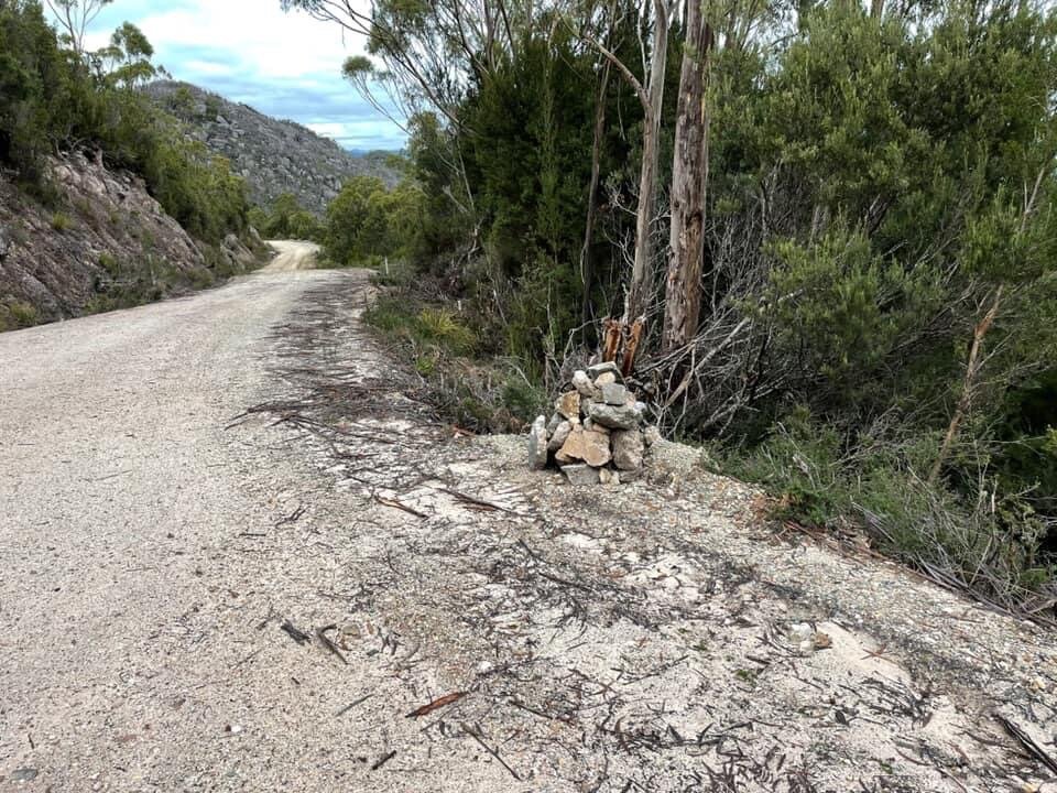
The cairn on Clear Hill Road indicating the start of the track proper (opposite side of the road to the cairn).
A reasonably sized cairn on the side of the road indicated we had reached the track. Some cutaways along the road further allowed for safe parking nearby. Packing our micro-spikes was something we all agreed on, as we were pretty certain the rock nearer the summit would be icy at the very least, if not snow covered. Pink ribbons on the opposite side of the road indicated the trail head. And when I say it starts climbing immediately - that is no exaggeration. Literally the first few steps are straight up from the edge of the road. This would set the scene for the initial sections of this track.

The pad goes straight up from the get go!
We found the track somewhat narrow to begin with. The scrub encroached well over the path, but the way forward was clear even with the enthusiastic scrub trying to claim some space on it. Some of the step ups were quite high for my short legs and so pulling myself up the steep slope with the encroaching vegetation was a bonus. It was also muddy. I suspect that all year round this section of track may see a little mud, as not too much sunlight would penetrate the forest canopy.
I was doing my best to keep up with Chris. He is a speedy guy on trail! The thickish tea tree, bauera and cutting grass both helping and hindering our progress. Not surprisingly given the steep climb, it was only about 15-20 minutes before we were treated to our first views of the Gordon River below. Above us, mist still hung heavy but there was no wind, nor was any forecast. Still winters days are just the best in my opinion.
Fire, fire.
Breaking out of the head high scrub, two things happened. The gradient suddenly flattened out considerably, and the scrub was replaced by sporadically placed boulders of conglomerate. Great chunks of lumpy, bumpy rock! Gorgeous big misplaced boulders of every shape and size. Charred evidence of fires in 2019 was everywhere. Blackened white waratah trees with bright green ground cover made up the terrain we were now walking through. Weaving in and around and sometimes through the large conglomerate rocks, we continued following the pad. Occasional pink tapes or cairns indicated the way forward, which were helpful where the pad became faint through the sparse, burned landscape.

The burnt out but regenerating landscape.
Walls of rock.
At one stage, the track led through two giant slabs of rock, dropping some elevation and depositing us on a small area of mossy and very wet marsh. From here, we enjoyed views to Lake Gordon on one side, and Clear Hill's sloping slabs of rock on its eastern face were really quite spectacular on the other. Once again, we began to climb up and, for the first time today, some patches of crisp, white snow crunched under our feet. Winter had arrived. Looking upwards, one might get excited thinking that you were looking at the summit - but alas, no. The actual summit lay further away, behind the next high point we would climb.
Button Grass.
I hate to see that fire has damaged our beautiful natural areas, but the honest truth is wading through burnt and regenerating button grass is far easier and less taxing than pushing through thick fields of it. While the charred ground made for easier passage through the scrub, it also makes it appear like there are pads everywhere. The few pink track markers and cairns here and there certainly keep you on track and ensure that multiple new pads aren't formed accidentally.
Rocks, glorious rocks.
Leaving the bog behind, we quickly gained elevation as the terrain underfoot was now predominately rock. Not scree as such, but rather rocky outcrops dispersed through very low lying vegetation. Up ahead, we could see the next rise but still not yet see the summit area. The track sidled round a huge boulder that was brick like at the base and chucky and round up top. It was sloping downhill. Seemingly balanced like that for all eternity. Nature really is pretty magical.

My favorite rock of the day!
Snow! Ice!
It was exciting to see snow more than a little lightly covering the vegetation below the summit. Unfortunately it also covered the track, so we had to pay more attention to our navigation, lest we wander off, distracted by its beauty. I was glad to have my wet weather pants on too; although it wasn't raining, the wet vegetation was starting to dampen the boys' trousers. Our pace had slowed considerably as we had hit the scree, covered in slippery thick slabs of ice.
Where ice was absent, snow was present. Unfortunately not enough to safely cover the gaps in the rock, but enough to hide what was underneath! That meant a lot of double stepping to ensure it would hold our weight. The scree field below Clear Hill's summit isn't huge by any standard, but covered in ice and snow like we had, it definitely chewed a little time negotiating our way up. We all agreed that the micro-spikes would have to make an appearance for the descent - well except for me as it turns out I had left mine in the car! Duh!

Descending briefly before the summit climb starts. From here on in the snow cover would get heavier and heavier.
I spy a trig!
Looking up, we could finally see the trig! All that stood between us and touching it was more ice and snow covered rock. Scrambling up the boulders, whilst also being careful not to slip all the way back down, we had the trig in hand! The summit was frosted nicely with snow and the air was chilly but still. Not a breath of wind disturbed our silent appraisal of the views around. Lake Gordon to our west, Stepped Hills to our north, Mt. Wright further to the north-east, and the amazing Gordon Gorge slicing through the ridgeline up to The Thumbs to the east.
Looking across from the trig we were all quite certain the rocky outcrop opposite was higher, so we headed over to admire the views from there. In a tad over two hours we had made it to the summit from the car. Even though the sky was dull, it didn't diminish the views. Instead, it added a whimsical allure to the vista below. It had been a delightful day walk through unique rock formations, and looking across to Stepped Hills was already inspiring our next adventure.
The stats.
Distance: Approximately 4.5km return from Clear Hill Road.
Time taken: Despite a pretty slow pace for photos, filming and due to snow and ice we were at the summit in around 2 hours. In fine weather without too much distraction this Abel could be completed in under two hours.
Difficulty: Easy but steep. Though a fairly short distance, the track climbs upwards steeply from the get go! The pad is obvious with frequent cairns and/or ribbons but can get covered over with snow during winter. There is considerable boulder scrambling towards the summit which in fine weather does not pose a problem. We had just enough snow and ice to be a slip risk, so care should be taken in the colder months. The track does not cross any water courses so ensure enough water is carried.
Type of track: The 2019 bushfire has significantly affected the surrounding vegetation, but for the most part the track is obvious and well marked all the way to the summit.
Access from: Clear Hill Road.

Route taken to Clear Hill.