Collins Bonnet
Date: 15th June 2019 - Summit: 1246m

Views from the summit of Collins Bonnet. Photo Credit: With thanks to Vivienne Bartle.
With perfect weather forecast for southern Tasmania - and me long overdue to catch up with my family in Hobart - a triple Abel adventure was planned. A friend and I set our sights on Collins Bonnet, Trestle Mountain and Mt Marian. These three peaks are relatively close together and all linked by the East West Trail. To add a little variation, and to shorten the hiking time in between each summit, we decided to take mountain bikes and ride the interconnecting fire trails. What could go wrong?!

Looking up to Collins Bonnet small summit. Photo Credit: With thanks to Vivienne Bartle.
We had stayed the previous evening with my parents in Blackmans Bay, and as such only had a relatively short drive to Collinsvale. On reaching the end of Suhrs Road - and the start of the Collins Cap trail - we were presented with two equally descriptive signs indicating we had arrived at the precise parking area.
To our left, an official sign from Parks indicating the "landowner graciously gives permission for you to use this track". To our right, a sign presumably from the landowner indicating there was nothing gracious about it! Whilst I wanted to run for the hills, Ben felt confident there was no one waiting to kidnap unsuspecting hikers! We unloaded our mountain bikes and proceeded to ride the gravel farm road for approximately 500m to the next sign that indicated the start of the Collins Cap Trail. Note the Collins Cap Trail and the Collins Bonnet Trail are two entirely different tracks - as are the respective mountains they're named after.
The gate that stops at the boundary of the land owner's property, and indicates the beginning of Wellington Park was locked, including the small foot traffic gate. It appears that it has been locked to prevent vehicle traffic but it also means you are required to climb over the gate. Inconvenient, but not difficult for most people. We lifted the bikes over and then after a very small hill you arrive promptly at Wellington Park.
The initial trail gently rises through sassafras, fern and myrtle forest, is well padded and easy to walk - or in our case ride - on. We were making reasonably quick progress at this stage.
Unfortunately the gently sloped and well padded forest track rapidly became an awfully steep and rocky fire trail. Hard work if one was hiking it, but near impossible to ride! We crossed our fingers and hoped that it was just for a small section as we did not relish the thought of pushing our bikes all the way to the start of the Collins Bonnet Trail! We were both pushing our bikes for most of the day!
Our pro tip for these Abels - don't take a mountain bike! Alas, almost the entire next 4km was so rugged and steep it was impossible to ride. I was using the most unflattering language whilst hauling my mountain bike up and over largish rocks and consistently coarse and steep trail. It is normally the legs that get a good workout on our hiking adventures, but today my arms, shoulders and back were feeling it. With almost 400m of elevation gain from the car to the base of the Collins Bonnet Trail it was a full body workout indeed!
Mercifully the trail flattens out as Collins Cap is passed and we could enjoy a brief period of pleasant mountain biking as the morning warmed up.
There are no navigation skills necessary or even a change of route until the East West Trail is reached. This allowed us to delight in the beautiful scenery without having to think too much about where we were heading. Whilst impossible to ride and very steep to hike the trail is extremely picturesque.
Every now and then we were treated to a tiny section of flat or slightly downhill trail which meant we could climb back on the bikes only to round the next bend and be faced with more steep, rocky and generally un-ride-able trail again. With around 600m of elevation gain in 8km it is certainly not the steepest mountain we have climbed, but with mountain bikes in tow it was proving to be a challenging day!
It took us just over an hour to cover the 4.3km to the junction sign marking the intersection of the Collins Cap Trail to the East West Trail. The temperature was cool but we were warm from pushing mountain bikes uphill! Very small amounts of ice were starting to appear on the track but the sun was still shinning.
Looking west over Trestle Mountain (left) and Mt. Marian as we ascend the East-West Trail towards the Collins Bonnet Trail.
A few pedals past the sign indicating the East West Trail we changed to an eastely direction, ditched the bikes and started walking the sharply-climbing fire trail to a storm shelter. It would have been near-on impossible to bring the bikes on this section of trail, such was the elevation and terrain. The trail varied from small and slippery shale-type rocks to large, almost watermelon sized stones. Water had washed down some parts of the trail causing troughs - easy enough to negotiate on foot. We had left our bikes at the base of the very steep hill leading off the East West Trail, and I was genuinely hoping someone would steal mine so I had a good excuse to hike the rest of the day!
The fire trail briefly levels out as a small plateau is reached just past the emergency shelter. About 100m past the shelter we located the walking track on the right which splits off to the summit. The minor amount of ice present earlier had increased quite noticeably as we got higher. We also noted that we would soon be stepping off the fire trail to a small scrubbed area and our ice covered scree adventures would begin. Not as easy to grip on in the trail running shoes we were wearing to accommodate our mountain bikes. I missed my hiking boots at this stage. Ben is in his element on scree but even he was moving cautiously because of the lack of grip.
The summit track up to Collins Bonnet consists mostly of boulder-size scree with brief sections of short scrub. Ice made the going rather slippery in parts.
The remainder of the hike to the summit would involve crossing over more icy and black moss-covered scree, which slowed our progress. The route is marked with the occasional pole and cairn but can get a little less obvious in places as it enters and then leaves small sections of scrub, to again open out onto scree.
Nearly at the summit, we looked back to admire the views of the Derwent Valley opening up below us. With only waist high scrub surrounding us our views were not blocked at all by any vegetation. The day was still crisp and clear at this stage, but the wind had increased noticeably.
Near the top of the summit, the track took a sharp right turn and some clambering over dolerite boulders deposited us promptly at the summit trig. Expansive views of Mt Wellington blocked the eastward horizon but we enjoyed the views of the nearby Trestle Mountain and Hartz Peak. Growing up in Hobart, I had always seen Mt Wellington's imposing southern side from my parents' kitchen window. Similarly, Ben grew up seeing its eastern face from his childhood home in Dodges Ferry. For both of us to see its impressive mass from the less-well known western side was quite moving, as you get a sense of its grandeur and scale.
However, with an icy wind stirring on the summit it was time to head down the track, find those damn mountain bikes and journey onward to Trestle Mountain.
The stats.
Distance: 12km return.
Time taken: Mountain bike riding from the car to the beginning of the Collins Bonnet Trail Head - 4.3km, 1 Hour and 10 minutes. To hike the Collins Bonnet Trail - 3.6km, 45 Minutes (return). From here we headed onwards to Trestle Mountain and Mt Marian before returning via the East-West and Collins Cap Trails back to the car.
Difficulty: Steep in sections and definitely rocky, but otherwise easy to navigate and ideal for beginner hikers.
Type of track: Fire trail and single track, all well marked.
Access from: Suhrs Road, Collinsvale. Note that there are multiple entry options into Wellington Park - refer to the Wellington Park access map for more information.
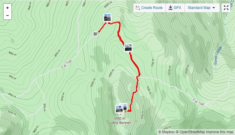
Route Taken to Collins Bonnet.