Cummings Head
Date: 26th August 2019 - Summit: 1260m

The summit cairn.
It was time to spread my wings, put on my big girl pants and summit my first solo Abel! I chose Cummings Head as it is well tracked, close to home and by all accounts relatively easy. Whilst I had successfully completed my first ever solo summit by the end of the day, the return journey was a merry adventure indeed!

The parking area.
Arriving at the car park at the end of Smoko Road around 8am I had made good time travelling from Launceston. I was equally nervous and excited about completing my first ever solo Abel. I had decided a few days before to attempt Cummings Head and so had duly marked out my map and set compass bearings. Previous discussions with numerous people who had already climbed Cummings Head, gave me some measure of reassurance that a solo summit would be safe. My pre-trip research included devouring the detailed description in the Abels Book. I felt prepared and the weather forecast was excellent. What could go wrong?!

Proof of life shot.
Upon arriving at the Smoko Road car park I was greeted by no less than three separate signs all pointing towards the same track that was signposted Mother Cummings Peak. One would assume that if you were to follow the signs you would be on track to the summit. WRONG! The three signs (and yet another about 1.5km further along the track) all indicate it is the route to the summit, but in fact, it is an older route no longer used that involves two creek crossings. Customarily in summer these creek crossings would not be an issue. Today they would form a reasonable water obstacle.
The Abels book mentions to take the track marked by a small cairn to the right of the signposted track, so in the opposite direction that the track sign sends you! I would have read that in the book the evening before but such was my excitement to start I just followed the sign directing me to the track start. I would later learn the sign leads many a hiker astray! I did not see the tiny cairn blending into the overgrown start of the alternate track, nor the minuscule piece of pink tape. Not sure why Parks has not changed the four signs that start you in the wrong direction, but it is what it is.
Note: If you happen to follow the incorrect signs don't panic as the route will take you on a scenic (but useless) 5km return trip to the car!

Small amounts of debris litter the unused fire trail.
After crossing the first of two very flooded creeks you arrive upon an old fire trail - easy walking. What are normally fairly dry creek beds that wouldn't pose much of a problem had swelled to flooded, deep and fast flowing water courses, due in part to recent lashings of rain and snow melt. The first creek is less than 100m down the trail - remembering this is the incorrect trail but the correct trail according to all signs! I wondered why Ben's friends who had climbed Cummings Head the day before had not mentioned the risky water crossings! I found two long and sturdy sticks in the surrounding bush - as I had not bought my poles with me - and waded into the water using the sticks to test depth and give me some measure of balance and resistance against the fast flowing current. The water reached just below my knees. Nothing like boots full of water less than a hundred metres in!

The very aged directional sign!
After wandering about a kilometre up the fire trail, which was comfortable walking but covered in a reasonable amount of debris due to infrequent use and storms, you will arrive at yet another sign that points you towards Cummings Head. The fourth sign in less than 3km to indicate the route is correct. I was elated that I was on track. I am renowned for getting lost on formed, obvious tracks! Whilst I was happy to be on the sign posted track I was quietly questioning to myself why I had been required to cross a creek when my perusal of the map didn't show a need for it. I assumed that it may be because the creek wasn't large enough normally to warrant being on the Tasmap.

Nope that is not on my map!
Another kilometre or so up the track the markers abruptly stop. Literally a dead end. I spent a little time hunting high and low for the next track marker. Up to this point the track was clearly padded out and marked with reflective arrows. Looking around in frustration I spy an orange track marker on the other side of the waterfall! I am now cursing out loud that yet another flooded and very fast flowing creek has to be crossed. Still, I wasn't about to turn back. I scouted around up and down stream to find the easiest and safest place to cross, fashioned another two sturdy poles from trees and stepped in. Again, the water was about knee high.

The three way track marker.
After crossing the flooded creek I arrived upon this marker. Now, if you happen across this marker from the other side of the stream (the old track) one arrow will point back to the water crossing, and one arrow will point south. So if one follows the markers you would head south right? WRONG! Clearly this has happened to others in the past as later I would discover when I was flicking through the photos and zoomed in - someone had actually tried scratching "Mother Cummings" into the arrow pointing in the opposite direction!
I remembered friends saying "just follow the markers" and so I did just that. However, I was beginning to feel like I was going in a big circle. I pulled out my trusty map and compass, and my previously set bearing was directing me bang-on North but the track markers wanted me to go south. My mistake here was not trusting myself. I thought I must have the bearing wrong. So I pushed on "following the markers". By this stage my Garmin was reading 4km. I was massively doubting the track markers as I knew it was only approximately 5km to the summit. Add to that the fact I had only raised roughly 100 meters or so in elevation. I was actually going down in elevation now, not up. Well, I thought, the track knows best. Maybe it contours round the mountain in the wrong direction before turning north again.

Easy sized boulders on some of the very small rock sections.
After going a little further and still feeling I was in an alternate looping universe I put the brakes on, cursed the track markers and decided to go old fashioned and follow my map and compass. I spun around and began going back in the opposite direction, retracing my steps and following the track markers (in reverse) but this time, using them in conjunction with my map and compass. I was more than a little miffed that I had walked almost an extra 5km - although it had been very pretty - I had wasted very nearly an hour. I reached the minor scree field I had climbed over previously and could see Mother Cummings peaking out behind the trees. I was tempted to bee line it to the summit but was curious where the track would lead so stayed on it.

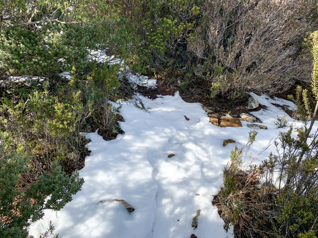
Snow remnants litter the trail.
Remnants of snow made the hike pretty without adding any extra difficulty. The crunchy snow allowed for better grip than moss covered rocks.

Reflective markers now leading the way.
I continued following the markers north until I reached the triangular junction point at the waterfall again. Coming in from this direction you could just make out a small red reflective marker up ahead that also matched the directional and magnetic bearing change I had plotted out the evening before. Yay! Thank god for old fashioned compasses and maps.

More snow and more markers.
A spring in my step again as my hiking course finally matched my map and the elevation began to steadily climb. Now the track markers appeared more frequently. Additional ground covering snow started to materialize as I climbed higher, but the sun was out and the elevation gain was gradual and enjoyable.
The pad hidden under increasing amounts of snow as the elevation climbed.
As I neared the summit the snow became deeper and the elevation pinch increased. The track was now marked with ribbon and not reflective markers. The occasional cairn also aided in navigation. Whilst the snow had deepened in spots it was not deep enough to hinder my progress. The track at this stage was winding upwards and along an old creek bed. It was somewhat closed in on all sides by head high bush but still reasonably easy going.
Looking behind me at Bastion Bluff as I climb steeply up the track.
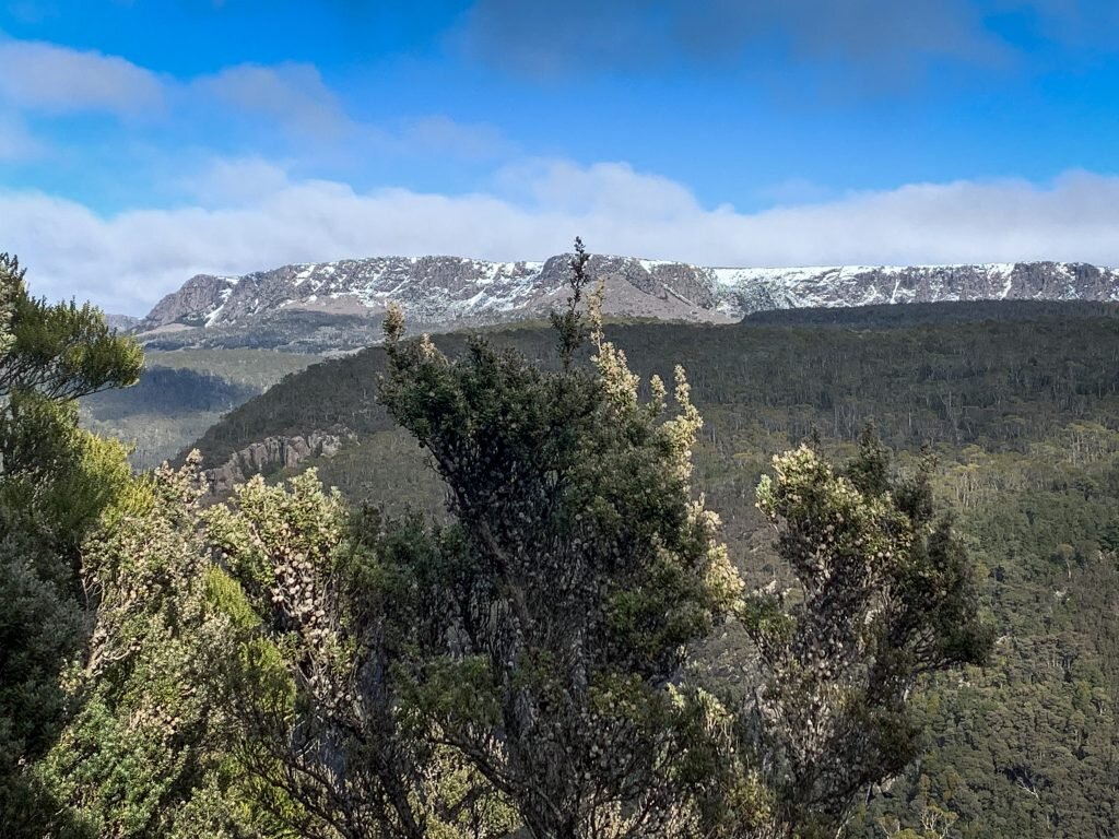
Almost at the summit plateau I stopped to message friends my whereabouts as my phone pinged indicating I had reception. There is no phone reception from the car park till reaching the summit plateau. My stop to send a current location SMS doubled as a chance to soak in the glorious views to the west of a snow capped Bastion Bluff and Mt Ironstone behind it in the far distance.

The huge cairn located at the breach in the ridgeline. This is not the summit cairn!
More or less immediately upon cresting the EDGE of the summit plateau you will arrive at an impressive cairn, which is not the true summit. You can understand why it has been mistaken for the summit in the past such is its size and grandeur. The true summit is approximately 200m southwards from this point. This cairn is impressive for a reason; it marks the entry and exit point off the summit plateau. The Abels book mentions waypointing the cairn as the entry and exit point is difficult to return to in poor visibility, and it is not easily sighted from on top of the summit plateau which sits a little higher. I did not mark this point as the sun was shinning, it was warm almost-Spring weather and a crystal clear day. In another 30 minutes or so, I would be kicking myself for not setting a waypoint.

Summit selfie.
I continued south on the summit plateau for another 200m or so and spied the true summit cairn. A summit selfie taken, and a quick text sent to my Abel bagging. All that was on my mind was what glorious spot I might sit in to enjoy my lunch and coffee. Even with my earlier track detour, I had made great time so a leisurely lunch would be in order!

Outstanding views and a clear sky…

Views from the summit of Cummings Head.

The first indication that the weather was about to take a rapid turn for the worse!
After spending a little time taking some photos and enjoying the views I headed to the northern end of the plateau to view Mothers Cummings Peak better when I felt an instant chill hit the air. Then, the wind started howling and the sky changed from a glorious clear blue, to a foreboding grey. In the space of 10 minutes the weather had turned from clear skies and sunny to a dramatic cooling, increase in wind and a thick mist began to creep over the summit plateau. I immediately turned tail and started heading back hoping I could outrun the weather off the summit plateau. NOPE. A big fat no from Mother Nature.

Within minutes I went from clear skies to total white out.
Visibility dropped to zero. Nonexistent. I could see no further than a few steps - if that - in front of me. Worse, not only had the temperature dropped and thick fog/mist rolled in but it had started to snow. I realised the "mist" was actually a big dumping of zero-visibility snow. I spent a few minutes trying to locate the huge cairn that marked the exit point off the summit plateau but with zero visibility I knew I was wandering in circles, blind.
No problems I thought; I have an expensive Garmin watch on my wrist for just such occasions. I will use the fancy Track Back function! No need to panic! I set the watch to Track Back . In theory this should have worked. I have not used this function before but I can tell you the best time to try to use it is NOT stuck on a mountain in a white out! Regardless, I set Track Back and started "following" it. Little did I know at the time it wasn't functioning properly.

My expensive but malfunctioning Garmin watch.
After a further 10 minutes attempting to follow the Track Back feature on my watch I was still wandering blind in the white out. By this stage I was a whole lot wetter and colder as the snow had turned to hail. I decided to give up finding the official exit point and just get off the summit as the plateau is very exposed. Better to be off the summit and then deal with navigation.
A lot of pushing through dense bush and I was off the summit and at least out of the worst of the extreme weather. It also meant losing phone reception though. I sat in the hail under some scrub and ate a few Peanut M&Ms. If you are lost on a mountain in a semi-blizzard then why not have a treat!
As the sugar kicked into my brain I reminded myself of the important things. If I needed a helicopter ride home I had a PLB. If I really had to, I had enough gear and food for overnight to wait it out. Not a comfortable night, but at least survivable. I had a watch I should have checked was working before I left for the hike. More importantly, I had done a navigation course for EXACTLY this situation! I sent a silent thank you up to Ashley at MountainSphere Adventures.

Down off the mountain and the sun comes back out!
Even though I did not know exactly where I was and had zero visibility to get a bearing off the landscape, I did know what I had seen and passed on the way in and what general direction I had come in from. I remembered the track loosely followed the creek going down the mountain. I remembered that I had come in from the south and that before the mist had rapidly descended and the weather abruptly changed, I had been enjoying the view of Mother Cummings Peak (not to be confused with Cummings Head itself) north of the summit plateau entry point.
Out came a few more Peanut M&Ms, the map and my compass. I set the compass for a south-west bearing and switched off the watch that had sent me in circles for the last 40 minutes. I knew on this bearing I would at some stage hit the creek and at the same time gently descend into the valley below. Still no visibility and loads of bush bashing, crawling, stumbling and getting generally beaten up by the mountain, but I knew that I at least was now heading towards the creek.
Within ten minutes I hit the creek and squealed happy squeals of delight as a few moments later I located the track. I was so glad I had not panicked (well apart from wondering how my son would get to work as I was now running late) and that I had used what I learnt in my navigation training to help me re-orientate myself.

Trusty compass and map.

After my snow blitz I was rewarded with a rainbow!
Now off the mountain and out of the white-out and weather, I took a few moments to have some cake and that coffee I should have had on the summit, and to appreciate the beauty of this mountain. I was a bit battered and bruised but more in love with my compass and map reading skills then ever before!
From white-out up top to a rainbow an hour later. Tasmania can really dish up four seasons in one day! Cummings Head itself is a variety of mountains rolled into one. From green lichens. mosses and tree ferns to King Billy pine and myrtle rain forests. Flowing creeks, scree and waratah complete the changing tapestry of this picturesque mountain.

Proof of life at the end shot!
I made quick time back to the car as I still had no reception and wanted to let my friends know that I had navigated out. I trail ran (in my hiking boots) the last few kilometres and was very glad to finally see the car appear in front of me! A rapid change at the car into some warm and dry clothes and I was ready to drive home. An hour and a half behind time but chuffed that I had not only completed my first solo summit but that when the going got tough, I stayed calm and used my skills to get myself out.
My biggest tip for this Abel is before walking ignore all three signs sending you to Mother Cummings Peak and instead look for the small cairn hidden on the right hand side of the main sign indicating an alternate route! Leave the scenic waterfall wander for another time!
The stats.
Distance: 12km
Time taken: About 5 hrs (including about an hour to re-find the track off the summit!)
Difficulty: Moderate. Just pay attention to the where the cairn marking the track comes out onto the plateau - it can be hard to find your way back if visibility is limited. NOTE: Do NOT follow the three signs at the car park to Cummings Head! Instead look for the small cairn marking the start of the track to the right of the main sign!
Type of track: The track is fairly rough, covered in moss, roots and is rocky, but well marked and reasonably clear for the most part.
Access from: The end of Smoko Road, off Meander Falls Road, south of the township of Meander.
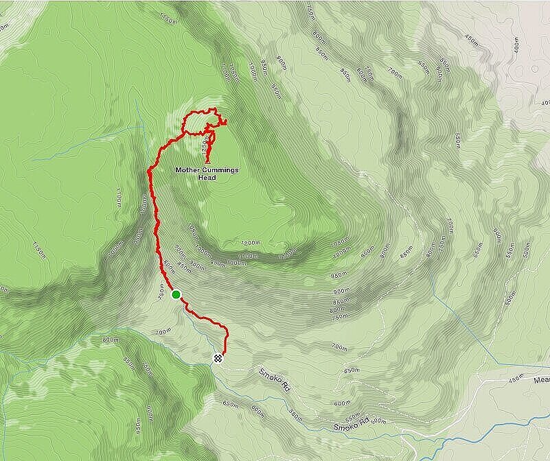
Route taken to Cummings Head via Smoko Road.