Eldon Peak
Date: 8th October 2023 - Summit: 1440m
Photo credits: Ben Wells, Tracey Orr

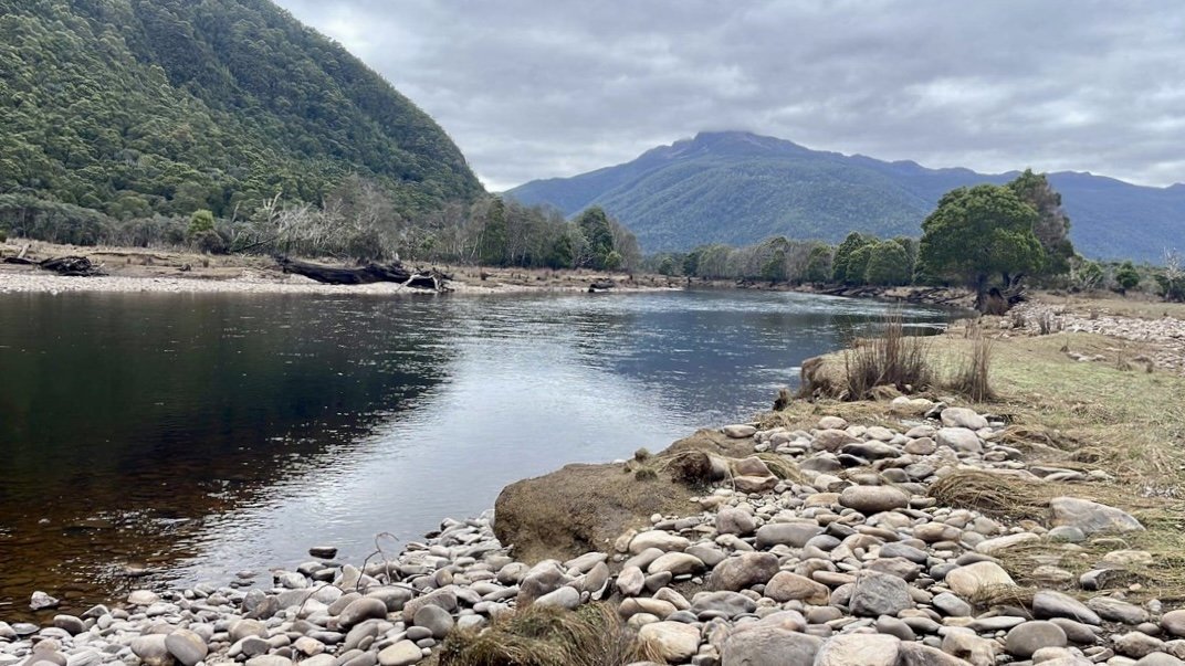
Eldon Peak rising behind us from the shores of Lake Burbury.
It was time to summit the remaining Eldons Range Abel on our list - Eldon Peak.
Back in January 2023 we had completed an out-and-back traverse of most of the Eldon Range. Whilst a ‘full traverse’ sees walkers enter the range at Eldon Peak and head east, a lack of available days had us instead venturing in via The Little Eldons.
This flip had also conveniently allowed us to exchange Eldon Peak for Tramontane - a reclusive peak that lies east of the Eldons Range - and in doing so we would witness a little bit of history in the making as RockMonkey Adventures touched her 158th Abel! A very worthy reason to drop Eldon Peak for another time!

Driving to Lake Burbury as it snows! Excuse the kayak rope blocking the photo!
There is always the benefit of hindsight when bushwalking. The luxury - after the adventure - of saying “we could have done this” or “we should have done that”. Having now climbed Eldon Peak from the shores of Lake Burbury, I am soooo happy… lets capitalise that… SOOOOO HAPPY that I was not climbing it with a heavy 12-day-plus pack, then having to traverse the lengthy rocky spine to Eldon Bluff! Mind you, had the weather conditions for day two of our trip to Eldon Peak been more favourable, I may have viewed the route east differently.
Our crew for this trip were a motley bunch of injured adventurers. Simon had stitches in his foot, Jess was still recovering from shoulder surgery, and Yours Truly with aggravated De Quervains Tenosynovitis in my dominant hand. All three of us going against sensible medical advice, but all three of us were prepared to wear whatever consequences came our way. Plus, it would make the summit even more satisfying when we got there - if we got there. Adrian and Ben were enviably firing on all limbs!
Our previous visit in May 2023 with water levels so low the boat could not progress even to this point.
I should mention that back in May, Bender and I had spent a weekend doing some reconnaissance with the help of his father, who’d generously boated us over Lake Burbury and up the King River, dropping us a few kilometres below the confluence of the Eldon and South Eldon Rivers. The late autumn water levels were so low at the time that we couldn’t physically get his small lake boat up any further upstream.
After making camp we had spent the afternoon following the remains of the old riverside track north to the confluence, and found a safe - if not exactly dry - crossing point across the South Eldon. We had also located the start of a marked route, and some campsites on the northern bank. All genuinely handy things to know for this future trip.

Our previous visit with water so low we could see the rock lined edges of the lake. This visit it was all under water.

Walking on the water flattened grasses on our previous visit. This visit we kayaked over the exact same spot!
After much discussion, the five of us had settled on a plan to kayak across Lake Burbury and head up the King River as far as the water depth would allow. From there, we would push on via foot to the confluence of the Eldon and South Eldon Rivers, cross to the northern side of the South Eldon and make camp for the first night.
Whilst there is a fabulous local gent that (for a small fee) ferries excited walkers up the Eldon River, he can only take two passengers plus their rucksacks at a time in his boat. That would have meant multiple trips and extra logistics to work around, hence kayaks being our preference. Plus, it meant that the trip was less likely to be cancelled if it was not favourable boating weather, and we’d only be beholden to our own schedule.

Loading kayaks at the Lake Burbury boat ramp.

Loading up the kayaks at Lake Burbury.
Having said kayaks were our preference, I should be a little more honest - kayaks were everyone else’s preference. Definitely not mine! As a non-swimmer, the thought of spending hours upon hours in a floating piece of plastic over deep water isn’t in my Top 100 ways to spend a day!
But adventure is all about getting out of your comfort zone. I had Bender’s reassurance that should I go into the drink, he would be straight in after me! And so fast forward, here we were on the boat ramp at the Lake Burbury Campground, loading up our kayaks in preparation for launching into a darker, more wavy and foreboding Lake Burbury than I would have liked.

Decanting gear into the kayaks.
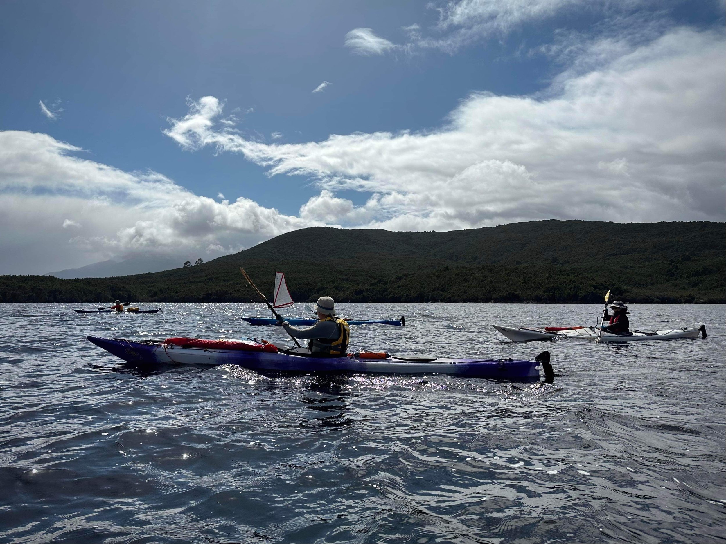
Setting sail - Jess quite literally - with her sail up.

Gloomy waters but at least its not snowing!
The paddle over to and up the King River took about 3 hours, 40 minutes. I suspect the others could have been a lot quicker without my novice paddling skills slowing them down but they all seemed to be enjoying the leisurely paddle and taking photos. (We made the return journey in 2 hours, 30 minutes due to some truly horrendous weather chasing us and thus a more determined pace). Bender had organised permission from Hydro Tasmania to fly his drone over the area, and took extended breaks to capture some birds-eye-view shots of our progress.
The kayak trip over the lake itself was “OK”. But as the exposed waters of Lake Burbury finally gave way to peaceful paddling up the protected valley of the original King River - who’s damming further south created the lake decades earlier - I was finally able to enjoy our surrounds. Lushly vegetated hills and furry green forest edging the river, reflections rippling away as our paddles hit the calmer waters.

A stunning birdseye view (with prior permission from Hydro Tas)
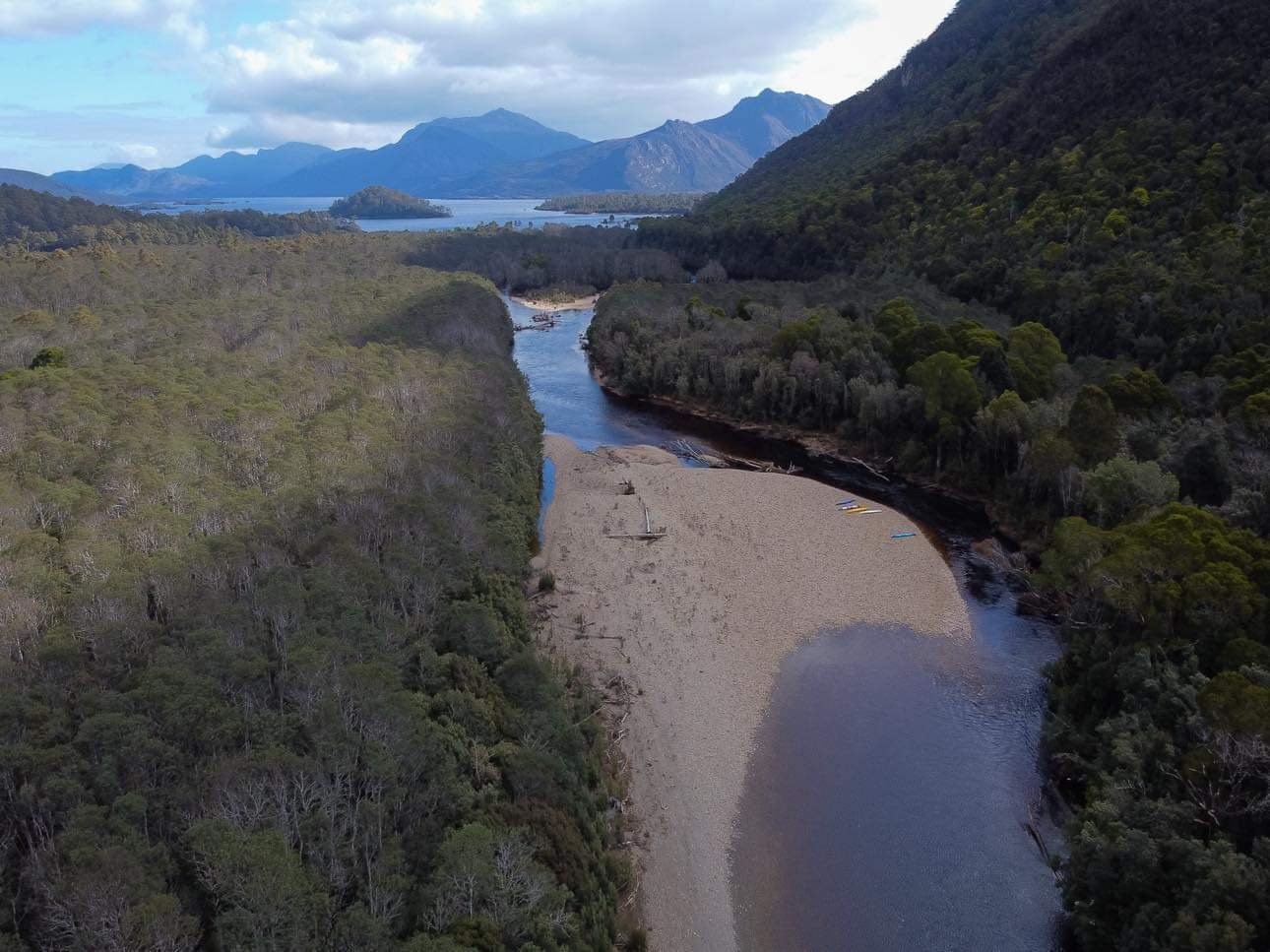
A stunning birdseye view (with prior permission from Hydro Tas). Note the kayaks beached for the weekend.

A stunning birdseye view (with prior permission from Hydro Tas). In calmer waters.
Bender and I were chuckling when we realised we were actually kayaking over our previous campsite, such was the height of the water level. We’d expected the lake level to be higher after the winter rains but were shocked just how much the level had risen - at least two or three metres. We kayaked in and around the trees we’d sheltered our tent near several months earlier. We paddled over the flattened dry grasses that our feet had crunched on during our previous trip.
As Simon observed, we were very lucky (and likely in the company of only a handful of people) to kayak this far up the King River, at least since its damming in the 1980s. A very real treat. Well, that was until Jess, who was leading the charge up the ever shallowing river, got caught in a fast flowing ripple and was promptly turfed out of her kayak! That was enough to send me immediately paddling to shore, happy to walk the rest of the way! The others likewise decided it was time to beach the boats and complete the rest of the trip on foot. It was less than 500m or so anyway to the campsite we had located on the northern bank of the South Eldon River.

Loading our gear from the kayaks onto our backs for the short walk to base camp.
Out of the water and looking for low/base camp spots.
After spending some time transferring everything from our kayaks to our packs, we headed off on foot. Bender and I had already walked this section on our previous reconnaissance trip, so I led the way north east through the light scrub sticking close to the shores. A few hundred metres along, we popped back out onto the pebbled shores of the South Eldon River to locate the shallow crossing point. Interestingly, since we were there last someone has placed a large cairn on a fallen log to indicate a crossing point. On the other side of the river, a tiny piece of pink tape tied to a shrub flapped in the wind.
Luckily the water level here was suitably low - about knee height at worst - and the wade across short. Mind you, the water was freezing cold! I’d had to get back into the cold water a few hours later when I realised I had left one of my boots in the kayak and had to retrace my steps to retrieve it. Still, it was still preferable to poor Jess who had been dunked in it!

Part of the crossing.

A tiny piece of pink tape on the other side of the crossing.
Once on the northern side of the South Eldon River, we wandered for a bit locating suitable tent sites for this first night’s low camp. There were numerous compact areas flattened out under the manferns to chose from, spread out along the river’s edge. The sound of the water would be a lovely backdrop to our night’s slumber. We all knew that tomorrow was going to be a big day. A very steep climb and less than perfect weather conditions would add to the adventure, so it was time to eat dinner and crash out, ready for an early start in the morning.

Base camp on the rivers edge.

Base camp on the rivers edge.
Before calling it a night, we had all agreed that step off time was to be no later than 7:30am. Given the terrain and the steep incline we were not going to be moving fast and so needed every bit of daylight early October would afford. Especially as we would have full overnight packs on our backs for the roughly 1200m climb in front of us. Research had indicated that, in fine weather, ascents had been made from the shore (with day packs) in as little as five hours, and as long as 11 hours.
Adrian was picturing a late lunch in the sun on the summit, 4 or 5 hours later. I was hedging my bets on 6 or 7 hours with full packs. Little did we know that the combination of spending almost an hour looking for Benders ‘lost’ InReach (it had fallen into his pack cover, thankfully) and hundreds of metres of large icy boulders on the final ascent would mean it would be nearly nine hours before we reached the summit. No lunch in the sun for us!

The spare tent we had bough to leave all our base camp gear in overnight. This would protect all our gear from the animals and the elements.
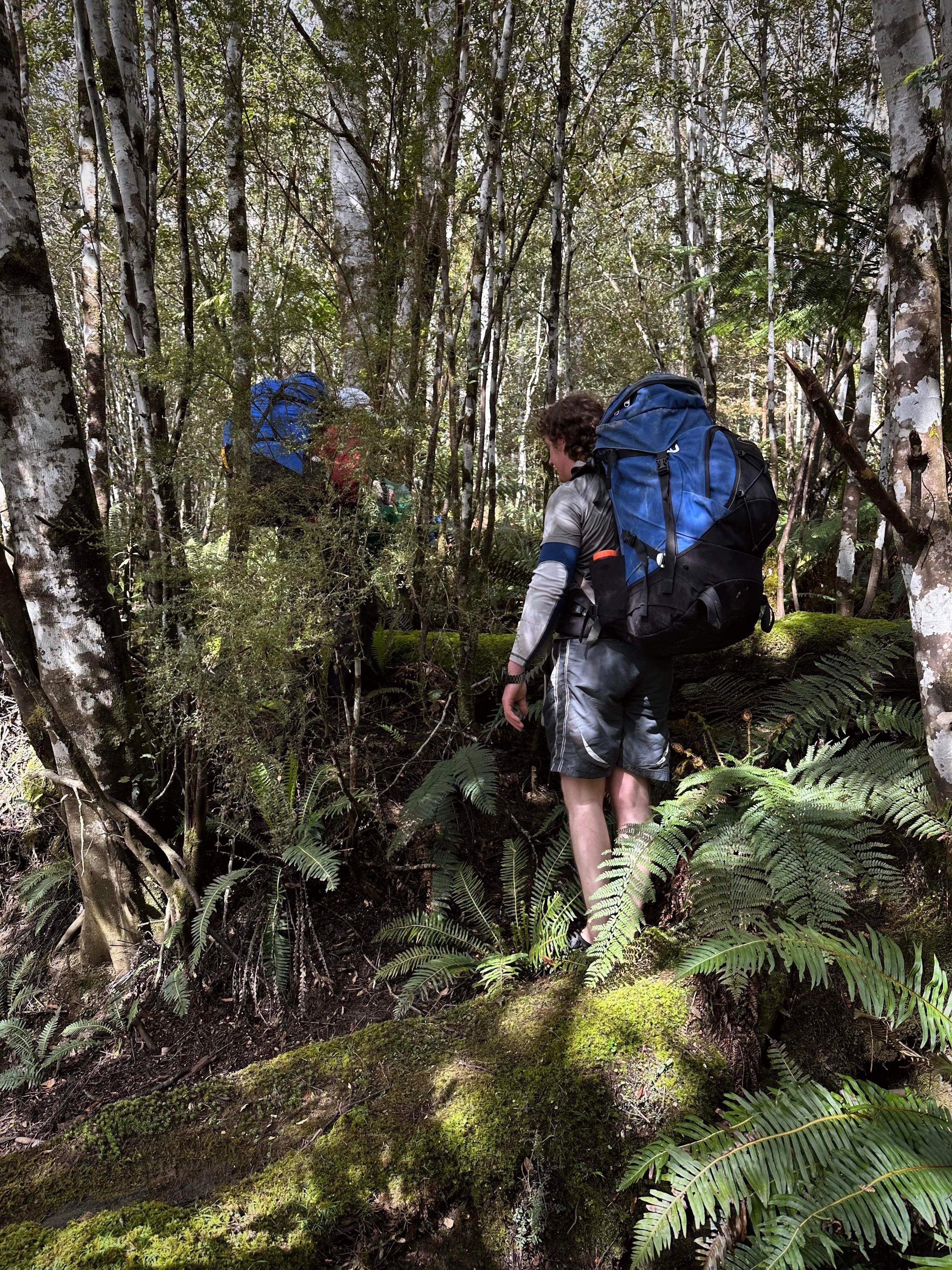
We chatted excitedly as we set off, following the well-spaced pink or orange tape we had found on our previous reconnaissance. None of us were silly enough to believe that navigation was going to be easy but we had it on good advice that there was a “cut” track further up the ridgeline.
We learned back in January that a “cut track” in The Eldons refers not to a manicured and obvious track, but rather sporadic cuts in the vegetation indicating an only somewhat-clear direction to wander. Simon, Jess, Bender and I had become adept at spotting these cuts on that trip and we looked forward to excitedly yelling “cuuuttt” when we saw the first one on this trip!

Leaving base camp.

The initial open and easy forest.
The open understory of rainforest made for gentle, pleasant walking to start with. Everything was shady and furry. Nothing more challenging than low ferns. It was probably too nice - we were all enjoying it and chatting away - leisurely wandering, meandering really. Following the reasonably frequent tapes and our own route off GPS. Sometimes there would be multiple pieces of tape, sometimes we would all be hunting around for the next piece. When it was non-existent we would split up for a bit, until one of us located another piece of tape or signs of a pad. In the absence of any cues, we would go in the direction that the route “should” go if it was there.

Staring down the first climb!

Just prior to realising we had lost Benders inreach!
There had been no real climbing at this stage, save for crisscrossing small creek banks and the navigation had been quite simple. The weather wasn’t terrible and we were all feeling pretty good until we heard a swear word vehemently and loudly exclaimed by Bender. His InReach was no longer in his pack pocket where he always keeps it. Crap!
I asked him if it could be in his pack or jacket, and a quick pat down all his jacket and pants pockets revealed nothing. So we all dropped our packs and started back in the direction we had come looking out for the bright orange device, but it would literally be like finding a needle in a haystack. A few minutes in I decided to head back to our packs and (ironically) still having some phone reception, I messaged our safety contact Haydyn to track it online and send me its location. I would also send a message to it, in the hope that the vibration and noise would alert the searchers.

Beautiful light and forest but no views of anything.

Crisscrossing small creeks.
By the time the boys arrived back, deflated after backtracking most of the way back to the river without luck, Haydyn’s message had come back to me and indicated that Bender’s InReach was where we were. That’s strange? Bender had been using his phone to see if if the Garmin app would connect to the InReach over Bluetooth… and suddenly it connected! What the hell? Umm… actually it wasn’t strange at all, as it turns out the InReach was floating in between his pack and pack cover! Oh well, it added some excitement to the day! Bender was just relieved he hadn’t lost his rather expensive birthday gift from me several years ago.
His InReach now safely tucked back in its correct pocket and many apologies given for wasting everyone’s time, we pushed on. After a brief band of tee tree and thicker scrub, the climb began in earnest. It was steep, really steep… like “lean forward on your toes and grab things” steep. The forest was still open though, and the occasional tape had been replaced with “cuts”. The story goes that an elderly gent - who appreciates his anonymity, so we shall call him “Barry” - has spent considerable time over the decades cutting the route towards the summit and to this day still maintains it despite such things running counter to modern day National Parks policy. That aside, we were more than appreciative of his efforts and would regularly give our thanks for the remainder of the trip.

It is the people you walk with that make each trip so special.

Simon smiling as we climb… and climb….
Upwards we pushed, making slow but steady progress due to chatting, the steep slippery terrain of the forest and the near-constant searching for the next cut or sign of the route upwards. Huffing and puffing, we stopped for a drink and Adrian mentioned we had only ticked off 50m of the 1200m+ climb. Not very flattering things were said in response to his comment. I think it was around this time we settled as a group on the three worst swear words known to man - “coriander” being one of them ;-)
One of my favourite things about bushwalking is the people we get to share adventures with. We love Simon and Jess and have walked with them on many occasions but this was the first time we met Adrian, who we soon rechristened with the trail name “Barry” for suitably random and inane reasons. He immediately fitted right in with our type of crazy.
Once the climb started, there was no relenting to the constant push upwareds. We measured our progress against the changing forest around us. Each change in vegetation was seen as a win, signalling elevation gained and bringing us closer to our goal of the summit. Whilst the forest canopy was lovely and it offered us protection from the less-than-ideal weather, it also stole any view of our surroundings. It became hard yakka. Just up and up and up through the endless green tunnel. No glorious views to feed the soul or distract the brain from now-tiring legs.
We took turns leading out front, searching for the next tape, cut or sign of a pad, just using common sense to stay in the centre of the ridge in their absence. The route was marked much better than any other section of The Eldons I have done, but it is still very much an off-track bushwalk. Definitely not a place for those that are inexperienced or are used to a well-marked trail.

Getting into the thicker stuff.

We measured our progress by the many changes in vegetation.

Sweaty work even in the cold!
Finally the forest canopy gave way briefly and allowed us glimpses through the low cloud and mist back down towards Lake Burbury. Above us, the shadow of Eldon Peak rose steeply into the cold and wet mist that hid it. It was also here that we again gave thanks to our mysterious trail angel “Barry”! So much effort has gone into this next section as we exited the open forest into head high tea tree and scoparia. Fortunately a clear route had been cut through, leading us through with scraggly mess of vegetation with surprisingly minimal effort. We all made a mental note to make sure we refound this lead on the return journey.
Without the protection of the forest canopy overhead it was getting noticeably colder. The wind was cold, the occasional drizzle was cold, and up ahead we could see ice and snow patches. The more open alpine heath gave little protection from the weather but did make for easy navigation at least. Here, a few sporadic cairns indicated we were heading in the right direction. Animal and probably human foot pads went off in every direction but even with the very occasional cairn we were back tracking every now and then to stay on course.

Our first views of the walk so far! Our kayaks are down there somewhere!
Sometimes the ominous mist would clear up briefly, and we would catch a glimpse of the boulder field that stood between us and the summit. Snow was scattered between big lumps of rock and I could tell even from this vantage point that a hiker’s worst nightmare - wet dolerite and black moss - were going to test us. And test us they did.

Mist stealing the views quickly.

Following multiple animal and or human pads that sometimes lead to dead ends and backtracking.
Reaching the boulder field, Adrian lead on, followed by Bender, myself and then Jess and Simon. It was a ‘choose your own adventure’ route. The boulders were either wet or covered in ice and snow, but they all had one thing in common - they were really slippery. And we all had one thing in common - we were cold.
In dry weather and with day packs, it would take no time at all to cover the upwards hop over the scree But we didn’t have great weather and we didn’t have day packs. Instead we had the sort of weather that slows one right down in this environment. Grip was minimal and we had to take our time, carefully picking our way up around the boulders. All of us had considered packing micro spikes, but considering how well into spring we were, none of us had bothered in the end. Now all of us were bemoaning that decision.

The days most challenging section. Wet, icy and or snow covered dolerite.

The days most challenging section. Wet, icy and or snow covered dolerite.
So we hauled, climbed, slipped and swore as the ice-and-snow-covered boulders made us earn every metre of elevation we gained. Looking left and then right. Wandering a bit this way and a bit that way, to try to find an easier, less slippery route. Never quite standing upright, lest your feet slip out from under you on the ice and topple you like a rag doll onto the rocks below.

Gorgeous ice patterns on the vegetation.

The days most challenging section. Wet, icy and or snow covered dolerite.
Jess was enjoying this section about as much as I had enjoyed the kayaks - that is not much at all. As Adrian, Ben and I waited on a small vegetated band below the final stretch to the summit, we discussed how to progress. There were two options available to us from here. The first, push on upwards over the final few hundred metres of icy boulders to just below the summit and then drop straight off the other side to make camp. Or option two, skirt east around the summit to try to get to the camp location quicker, in doing so avoiding what looked like very icy rock, as well as geting out of the elements and into warmth sooner.
My worry was that in the icy, whiteout conditions we couldn’t see far enough east to know if that option was even doable, let alone better. What if we pushed east over the boulder field, reached impassable cliffs and had to turn around and back track? We were all already cold and fatigued. None of us wanted to be out in the weather much longer.

The days most challenging section. Wet, icy and or snow covered dolerite.

Adrian AKA Barry not regretting his life choices at this stage ;)
Whilst waiting for Jess and Simon to reach us, we threw the merits of the options back and forth but struggled to make a firm decision. The wonderful Becca (aka RockyMonkeyAdventures) is a friend of all of ours. She is not only one of the most experienced bushwalkers we know, but she happens to have been in this exact spot with similar conditions to us some years prior, so we thought why not call her! She may know what access to camp from the east is like. Up this high, we had surprisingly good phone reception.
It was so lovely to hear her voice when she answered, and her rooster crowing in the background at random intervals had us all chuckling and lightening the mood as we discussed our situation. She confirmed that going east wasn’t really an option in the conditions (minor cliffs etc.) so it left us with the simple option of straight up and over.

Our chute! More appealing than large icy boulders.
Fuelled with a quick snack we pushed on, ever upwards over the increasingly icy boulders. Ahead, Bender spied a chute leading towards the top that had smaller rocks and lots of snow. Figuring it that was better, grippier option than large awkward boulders covered in ice, we headed towards it. Unfortunately the small rocks were loose and easy to dislodge, so it was with great care we climbed the chute. One at a time we went up so that any falling rocks would not hit the person below. Fair to say that wasn’t going to be fun going down the next day, that said none of the boulders were going to be!

Taken on the way down the next day. The chute we used to avoid some of the larger boulders.

Nearly at the top! Well about to breach the rim anyway!
I cannot tell you how good it was to finally climb out of the chute and crest over onto the summit area, and see vegetation mixed in with the rock, the summit itself less than 100m away and no wind! We were now shielded from the icy cold breeze that had been chilling us for the last few hours! Happy dance, oh happy dance, oh happy dance!
Just one minute later we were dropping our packs, grabbing a snack and heading up to the summit for… the worst views ever! We could not see a single thing! Still, we gathered around to plant our hands on the summit, with hugs and cheers and lots of words to the effect of ‘thank god that is over’. A few misty photos taken, and an agreement that if the weather cleared by tomorrow morning we would come back for a second look. And then it was time to make haste towards camp.

Yep - that about sums up the day!
Supposedly, the delightful tarns on the north-eastern side of the summit make a pretty camp. We would have to take the word of reviews, as we couldn’t see a thing. Donning our big packs again we made quick work of the short but steep descent down to our home for the night. At least the descent was through low scrub and everyone’s favourite - pineapple grass. We bottomed out on the shelf and scouted out three tent-sized flat areas in amongst the tarns. Finally, it was time to pitch the tents and get warm.
Eldon Peak had made us well and truly earn her summit. It had taken nine hours to get from base camp to high camp with big packs. Even without Bender’s little InReach mishap, it would still have been eight hours to cover the 10km and 1200+m of elevation gain. As the grey light in the mist grew darker, it was a relief to finally warm up and relax. Dinner tasted so good!

About to drop off the other side to locate camp in the mist.

Bunkering down for the night.
As I prepared for bed, thoroughly exhausted, I didn’t hold a lot of hope that tomorrow was going to be much fun. No views, icy boulders and tired legs. But… a new day bought shooting stars, much better weather, an alternate route to skirt at least half the boulder field, and a completely new “cut” track! But that’s a story for the morning.
During the night I heard Bender rustling for his head torch and camera. He often does that at random times during the night, so I rapidly fell back to sleep. Little did I know he had woken at 3am to a crystal clear sky and decided to pop out of the tent and have a look. There he sat watching falling stars and admiring the view whilst snapping away with his camera. Almost an hour later he climbed back into the tent, stating that he was freezing but it’d had been totally worth it - and that the morning should be a much better day.

Yeh I guess the views were ok ;)
And so when we awoke a few hours later, it was to the most glorious of sunrises. All the previous day’s trials disappeared when we saw that amazing orange glow outside our tents. This is why we do what we do, baby! The five of us excitedly got up and raced around our camp, snapping photos and ohhing and ahhing. “Look at this, look at that, look at Frenchmans, look at Barn Bluff, look at High Dome”. We were like little kids in their favourite toy shop. Man oh man, we were lapping it up. We packed up excitedly and made the short climb back up to the summit to see the views that had been denied to us yesterday. Our aches and pains forgotten, and a new spring in our steps.
On mornings like this, where everything comes together, it is impossible to describe the feeling of standing on a mountain with people you hold dear, looking at nothing but wild nature surrounding you. We are tiny, less than tiny, in the scheme of the universe. Just these inconsequential humans. Imagining how these mountains and valleys and lakes have been formed and what forces shaped them reinforces our own obscurity.

Hello sunrise!

Yep. It was even better than it looks in the pictures!

Really average camping. Who would want to camp here? ;)
It was really hard to drag ourselves away when Tasmania was showing us her very finest, but we still had a long journey back to the kayaks, and then a long kayak, and then the longest of drives home. Thanking Eldon Peak, we returned to where we had left our big packs a few meters below the summit.

Mountains floating in clouds.

Returning to the summit the next day in nicer weather with views!

Looking down on all natures glory. We live in a mighty fine place people!
Knowing Jess was not looking forward to the boulder field, we had agreed that Bender would go first and find small boulders and easier descents to assist her with from the front, and I could assist her from behind. That would leave Adrian and Simon to snap away with their cameras behind us. True to his word Bender located an as easy as possible route down through the boulders. At one stage we were even able to completely avoid a large chunk of the boulder field by using the vegetation to our west - vegetation that was visible with the day’s clear skies, as long as we were back on the boulders before the area we needed to rejoin the cut track we could use as much vegetation as we liked. With the benefit of heading downhill, it made for much easier and faster progress.

Time to start the descent back towards the kayaks.

Jess much preferring our return route using scrub where possible instead of boulders.

The boulder field behind us.
As we left the boulder field for the small more sporadic rocks that lay at its base, we briefly lost the “pad”. A narrow band of scoparia lay between us and some lower vegetation. I led through using what Bender refers to as my ‘wombat skills ‘to weave through it and in no time it was over and we were back on track.
Through the lovely cut section we went. Back into the forest canopy we went. All of us chatting and happy that we had seen such glorious things. And this is where things got interesting. We were very definitely on a “cut” track, BUT it was not the same “cut” track that we had used the day prior. It was heading where we needed to go and it was very clear, in fact easier to follow then the cut section of track the day before, but our GPS traces were quite some distance apart. Has someone cut an alternate track?

Time to drop off into the scrub.

I’m in the Scoparia seeking out a way through for us. Got to love it when its so tall it swallows you up.
As it was so good and it was going in the right direction anyway, we decided to stay on it. It was dropping us rapidly back down the ridgeline. Firstly Adrian and I out front, then Jess and I out front with Simon second scouting. We broke briefly for lunch, and pondered the odds of a second and quite distinct track being present.
After lunch, signs of the cut track disappeared but we had almost joined our route from the day before and so it was time to start picking up the odd piece of tape. As it turned out this tape led all the way back to our low camp. So there is indeed multiple options to take towards the summit. Is one better than the other? Not really they both take navigational skills and an acceptance to not rely on finding cuts/tape. They are both steep.

Lunch in a five star restaurant.

A comfy place to sit.

Back into it after lunch.
It had taken around 7.5 hours to descend and that had included all of our time enjoying the summit and a relatively leisurely lunch. However we wasted no time packing up our base camp, crossings the cold water of the South Eldon and heading back to our kayaks. The wind had again picked up, and it’s fair to say I was dreading the kayak back.
After decanting our packs into the the kayaks, Simon led my kayak downstream past the first rapid. It was now or never. Deep down I wanted it to be ‘never’. Eventually we made our way back down the relative calm of the King River and onto the lake itself. Here the weather and waves were much worse than our inwards journey, and I was honestly scared of being tipped over. Both the wind and waves would come at me sideways and leave the rudder out of the water and so steering wasn’t an option. I was hating every single second of it. Simon, Jess and Ben later admitted weren’t enjoying it much either. Adrian has had much worse, he said, so he wasn’t too fussed!
Desperation to get out of the conditions and little shelter along the way for rests made for a much faster return journey though, and it was with great relief that we made it back to the jetty in about two and a half hours. Exhausted, cold, stiff, sore and wet!

The stormy paddle back starts.

Back at the car after our adventure.
What an intense, physically and mentally demanding three days. Standing safely back at the cars, dressed in warm clothes and snacking on the delicious popcorn Jess had made, I didn’t regret any of it though. Sure, in a perfect world the weather would have played nice, the lake would have been calm and a Yellow Brick Road would lead straight to the summit but you know what - where is the fun in that?
The Stats.
Distance:
Ascent: From Low camp on the South Eldon River to the summit and then on to high camp - 9km, 9 Hours, 1220m Elevation Gain.
Descent: From high camp to the summit then to low camp and back to the Kayaks - 8km, 8 hours. This included time packing up camp and time enjoying the summit.
Time taken: See above.
Difficulty: We would classify this Abel as difficult.
Type of track: Untracked but occasional pads, cairns and tapes to the summit. A “cut” track - sporadic cuts in vegetation.
Access from: Lake Burbury.

Low Camp to High Camp via summit.

Paddle to low camp.

Paddle Home
The Map.
Route taken to Eldon Peak from the South Eldon River and our Kayaking routes.