Hartz Peak
Date: 8th June 2020 – Summit: 1254m

Hartz Peak Summit. Photo Credit: With kind thanks to Simon Kendrick.
I shall call Hartz Peak the 'Mt. Arthur of the South' - or perhaps even the 'Cradle Mountain of the South'. Meaning, it is a mountain that tourists hear about and want to climb. And climb it they shall - prepared or not! I should also mention; although a relatively short hike to the summit - at around 4km - in inclement weather it is anything but a friendly saunter for tourists. No mountain hike should ever be underestimated, and that includes the lovely little Hartz Peak. Today was a lesson in why mountain rescues occur.

Looking towards the summit. Photo Credit: With kind thanks to Simon Kendrick
Why not watch & read?
Please enjoy a visual trip to Hartz Peak in addition to the blog below. Whilst the blog gives you greater detail on the trip (including route information) the video allows those that may never reach its summit a virtual experience.
With COVID-19 restrictions lifted to allow for travel across Tasmania, I was excited to be able to head south and finally see my family. My plans were to enjoy family time on the Saturday and then climb "something" on the Sunday with a friend. The "something" needed to be closeish to Hobart and relatively quick to climb, as we would be returning to Launceston the same day. Hartz Peak fitted all our requirements nicely.

I am sure people see this sign and think its a simple stroll. Photo Credit: With kind thanks to Haydyn Bevis.
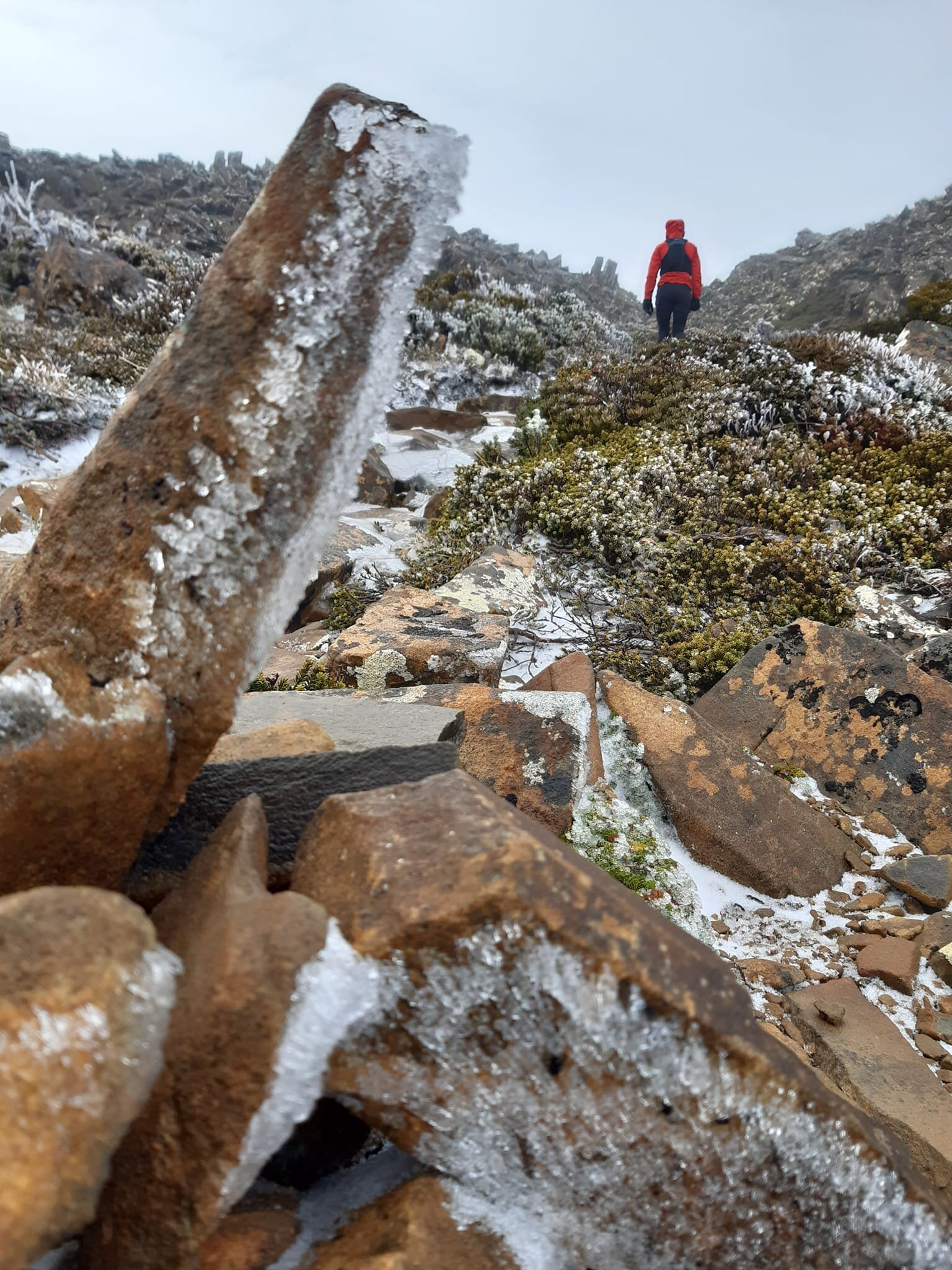
An early start from Blackmans Bay saw us arrive at the track around 8:30am. Frankly, it was freezing cold with blustery winds, but after months of being locked out of our National Parks we were happy just being amongst it again. We expected nothing less than winter weather, given photos on a local hiking Facebook page posted the day before showed snow from Hartz Pass onwards. It was an all-layers-on kinda day, and after rugging up and logging our intentions at the Visitors Station, we set off down the track.
The initial lower reaches of the track consisted of duck board, which led us southwards alongside the ridge towards the summit. Occasionally the duck board would be broken by short sections of rocky trail. The vegetation here would have allowed for lovely views as far as Bruny Island and the Tasman Peninsula, were it not for the scenery-stealing mist shrouding everything. The sun would occasionally try to break through, but would no sooner peek out and the wind would blow creepy, cold mist to cover it again.
After only a very short time wandering the trail we came across the memorial for Arthur and Sidney Geeves, who died in a snow storm back in November 1897. The Geeves family founded the township of Geeveston and cut the first track from Geeveston to the Hartz Mountains. As a result of this track, Hartz Mountains became one of Tasmania's earliest popular bushwalking destinations.
Tragically on 27 November 1897, Osborne Geeves and his three sons and their cousin, Sidney, were overtaken by a blizzard when returning to Hartz Hut from a prospecting expedition near Federation Peak. They struggled over Hartz Pass to Ladies Tarn, but both Arthur and Sidney were faltering. Within only a few hundred metres of the old Hartz Hut, Sidney was carried to the hut but he died soon afterwards. Arthur was left with his father, and died in his arms. A poignant reminder of how cruel mountains and their weather can be. Also a reminder that you can be so close to shelter and it is still not close enough in the direst of times.
The alternating rocky trail and board walk led upwards gently but with the occasional short steep pinch. The vegetation was open and the area exposed for the most part, and after approx 1.5km we reached the track junction for Lake Esperance. Given the morning's mist cover and low visibility, we knew better than to think we might get views of the lake and so continued southwards towards Ladies Tarn.
Whilst the track was relatively flat and the terrain underfoot easy to traverse - given the duckboards and well maintained rocky path - the going was anything but! The wind across the open moorland area to Ladies Tarn was belting us, at times pushing us off the track. Even the ridgeline of Devils Backbone off to our west offered us no protection.
The climb to Hartz Pass. Photo Credit: With kind thanks to Simon Kendrick
Climbing a minor rise after Ladies Tarn, we finally enjoyed just a small amount of relief from the cold wind as we entered a patch of higher vegetation, through a brief field of pandani. The board walk now gave way to a path entirely of rock and tree roots. We climbed higher and closer towards Hartz Pass, with the trail rising markedly in elevation for a few minutes.
Our shelter from the elements came to an abrupt end as we stepped out onto the exposed plateau of Hartz Pass. From here we would follow the signpost indicating the peak southwards. Through the mist we could make out the silhouette of the first high point ahead. We knew the summit lay beyond that and we still had a climb ahead of us. The wind was doing its best to make us turn around. Whilst it was cold and windy, we were both dry beneath our outer layers.
Reaching the top of the nearest high point, the track plateaued again briefly, with the next high point barely a silhouette ahead in the distance. Now remnants of snow and ice littered the rocks below our feet. Unfortunately not enough snow remained to justify putting on our microspikes, but just enough ice remained to make the going slow and slippery! Combine that with the strong winds and we might have appeared to any passer by that we had enjoyed a few alcoholic beverages along the way - such was the side lean we needed to maintain to stay upright!
Finally the remaining high point and the summit came into view - well became barely visible in the mist trying its best to hide it from us! Rock steps led us to the base of the final climb and our mission was nearly complete.
A few minutes scrambling over the icy rocks and we soon reached the summit. Here we found the remains of an old beehive shelter and two high points, one cairned, one not. There was nothing else to do but touch both. Lucky they were a mere 10 metres apart. I decided to bunker down in the beehive shelter and enjoy some coffee from our thermos.

Summit rocks. A spectacular photo with thanks to Simon Kendrick.
Both of us soon decided that we would return in summer as a trail run, just to see the views we had missed out on. For now, though, it was time to get out of the terrible weather and off the mountain. Now for the homeward journey story...
I once saw a lady in denim jeans, ballet flats and carrying a brown leather handbag whilst climbing Cradle Mountain. I was reminded of that moment each time we passed an unprepared walker on our way back to the car after climbing Hartz Peak.
I was a little appalled - when during our return hike at least half of the people we passed on the trail were completely unprepared for the conditions. We saw walkers in denim jeans, women in light 3/4 tights with tennis shoes on (not even sneakers), whole groups shivering with no wet weather protection on, men in footy shorts, a lady with a t-shirt and scarf and nothing else - the list goes on. Most were not carrying any sort of back pack, gear or food. Some with absolutely no idea about the walk, asking us questions like "Does it get colder up there"? "Is it very far to the end"?
The Hartz Peak climb is to the general non-hiking public "only 4km". Perhaps people don't understand that if you injure yourself or become incapacitated during freezing conditions like these, it may be hours before a rescue party can get to you. Distance isn't the only consideration - time is, exposure to the elements is. Does it come down to education? Does it come down to signage? Does it come down to personal responsibility? Who knows what the answer is. If a memorial a couple of hundred metres along the track doesn't make people question their preparedness, maybe nothing will.
The stats.
Distance: Approx. 8.5km out-and-back
Time taken: About 3 hours return, including numerous stops for photos and videos as well as lunch at the summit. Official PWS guidance is 3-4 hrs return.
Difficulty: Easy in fine weather.
Type of track: Formal track of mostly rock and some boardwalk, marked to the summit.
Access from: Hartz Road.

Route taken to Hartz Peak.