Mount Achillies
Date: 29th December 2019 – Summit: 1363m

Early morning view from Mount Achilles. Photo Credit: With thanks to Trip Bucket.
I love Greek mythology and the name Achilles brings thoughts of the Trojan wars and the heroic fighter - Achilles. I am also more than a little partial to the Hollywood movie Troy which portrays Achilles as Brad Pitt a fierce warrior but romantic at heart. For no other reason than its namesake I was eager to climb Achilles. Such a romantic notion. Mt. Achilles offers little by way of romantic stroll but instead lives up to its mythical reputation.
A friend and I had hiked into and made camp at Leonards Tarn the day prior. We had underestimated both the days heat and the full pack climb from the OLT and as such, we awoke less than refreshed, somewhat dehydrated and without our usual enthusiasm for clambering up steep things!
Still here we were so best get to it. The Abels book describes a steep but relatively short climb to the summit from Leonards Tarn. It was around 8:30am which is a late start for me, and already the day was excessively warm. We loaded in extra water - not wanting to repeat one of yesterday's mistakes (getting dehydrated) - even though a tarn is shown in the saddle between Mt. Achilles and Perrins Bluff and set off.
We initially located a very obvious pad leading southwards away from Leonards Tarn. The pad seemed in the distance to be leading up to the saddle between Mt. Achilles and Perrins Bluff. Great - we thought.
After following the pad for about 15 minutes it began to climb through an area of dead pencil pines but ahead of this lay very dense scrub as well as a massive drop in elevation into a steep gully. Further still beyond the gully, we could see the saddle we wanted to be on but it was surrounded by cliff faces.
Clearly a well padded track to the middle of nowhere! Cursing the waste of time, we turned back in the direction we had come from towards Leonards Tarn. After briefly considering just climbing up onto the saddle between Mt. Achilles and its northern heel we settled on the road more travelled and the accepted route towards the Perrins Bluff - Mt. Achilles saddle.
After retracing our steps almost all the way back to Leonards Tarn and to the foot of Mt. Achilles, we decided it was as good a time as any to just start heading skywards! Looking up we could see pockets of scrub and scorparia interspersed with rock, scree patches, shale slip areas, cliffs and boulders and finally a bright green lawn-like area we thought we could enter the summit from.
In true Xing style we threw out the directions and began making our own path up. Our loose plan was to make it above the scrub line onto the scree all whilst sidling towards the saddle.
The scrub proved a worthy adversary; nothing like the horrendous bush-bash of the day before but certainly enough to make the going slower than we needed in the building heat of the day. No sooner would we reach a small patch of rock then the scorparia would start again.
At least our elevation was increasing but so too was the mercury, and we were both cursing the summer heat. Yesterday's exhaustion was definitely impacting on us and we were mindful of not running out of water as we had the day before. Continuing the steep climb upwards we eventually made the first belt of solid scree hoping the going would be easier.
Whilst the scree slopes freed us from the laborious task of pushing through scorparia and dense alpine vegetation, the going was only marginally easier. The scree slopes were angled very steeply, meaning one was always on a sideways lean, and the bulk of rock was more like shale. With rocks slipping out from under our feet constantly it wasn't enjoyable to traverse. I had visions of myself slipping all the way off the mountain and so requested we stick to the lower levels of the shale slopes to minimise any potential fall.
It was a relief to make the shade below the cliff faces which make up the southern end of Mt. Achilles and our lawn-like grassy patch. We now had the option to head towards the saddle and continue as per The Abels book description. However, that would have meant an unnecessary southern deviation from our current location. Given our already low energy levels were dwindling rapidly, any deviation or extra effort wasn't welcome. The boulders we were climbing were large and blocked our view towards the summit but we figured if we reached boulders too large to climb or a dead end we could still turn and head to the saddle and so we pressed on.
Clambering over the last large boulder in our path bought us out to just below the summit area and gave us a brief respite from the consistent upwards climb. From here we could see small cairns leading towards the summit meaning we had crossed paths with the route from the saddle. It had actually been easier coming up through the wedge on the south eastern side of the summit after all. We hadn't managed to make up the time we had lost at the beginning of the day but we hadn't lost any extra time at least.
It was relatively quick and easy to scramble to the summit which is characterised by a spire of rock and magnificent views or Leonards Tarn, Mt. Pelion West, Mt. Thetis and the northern peak of Perrins Bluff. It would be in the direction of this northern peak that we would head to claim the summit of Perrins Bluff after a little time soaking in the well-earned views that Mt. Achilles offered.
Note: For any Abel baggers heading out to claim Mt. Achilles from Leonards Tarn my advice is this - head to the southern end of Leonards Tarn. Then, locate a distinct pad just past the location of the sign-in book - this is somewhat hidden in an sheltered camping area. An old tree root marks the location. This pad leads you directly to the saddle between Mt. Achilles and Perrins Bluff and avoids the dense scrub, the dodgy shale rock sections and allows for a quicker and easier passage to the summit. How do I know this? We found the track on the way off the saddle. Too late to assist us as we had already climbed the hard road to the summit but enjoy this sneaky find compliments of Xing!
The stats.
Distance: Approx. 6.5km return from Leonards Tarn.
Time taken: 1 hour, 50 minutes to the summit due to misdirection and scrub bashing. Locating the track at the southern end of Leonards Tarn (see note at end of blog) would substantially reduce this time. We returned via the pad which was obvious from a higher vantage point.
Difficulty: The Abels book grades Mt. Achilles as "hard" given its isolation, the requirement for camping and the terrain encountered. We won't disagree.
Type of track: Untracked but a distinct pad leads from Leonards Tarn to the saddle between Mt. Achilles and Perrins Bluff where the cairned route begins.
Access from: Leonards Tarn.
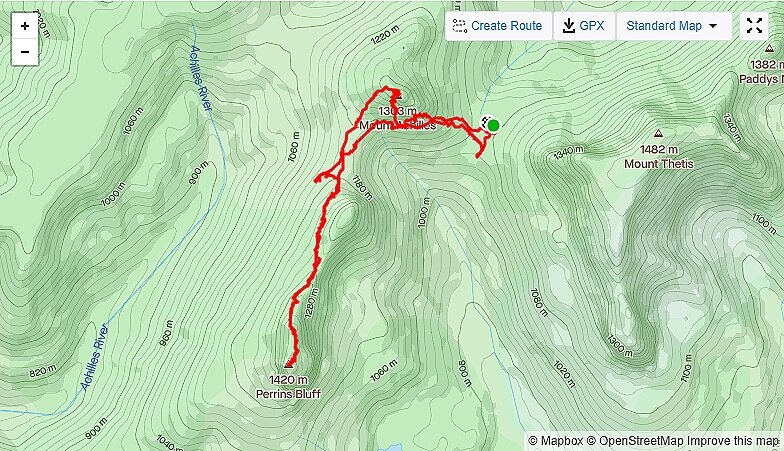
Route taken to Mount Achillies and Perrins Bluff from Leonards Tarn.