Mount Byron
Date: 23rd July 2021 - Summit: 1375m
There is always something exciting about a solo mission. It’s the thrill that comes from being 100% solely responsible for yourself. Your successes or failures during the adventure depend on no other person but you. I kinda like that. Plus, you have the added bonus of going at your own pace, enjoying true solitude and hogging the tent space. What’s not to love?!

Lake Petrach barely visible below through the snow and mist.
With a three day weekend coming up but the weather gods being foul I prepped multiple walk options. Horrid winter weather was forecast for pretty much the whole of Tasmania.
The decision about where to head would be made at the absolute last minute. I intended on pointing the Mazda towards whatever mountain offered the best forecast.
Finishing work at 6pm on the Thursday night, I did a quick weather check and settled on Mt Byron. It would be snowing lightly on the Friday increasing to heavy late on the Saturday. My rough plan was to climb Friday, and either camp at Byron Gap or drop down to Narcissus Hut should the weather crack up early.
Leaving Launceston behind my excitement increased. The excitement must have been distracting me as I ended up on the wrong road, and had to make a quick call to a mate Haydyn to get me back on track. I am great with a compass and map but useless with following a sat nav!
Arriving late to Derwent Bridge I fell asleep to the sounds of critters outside and infrequent sprinkles of snow. The temperature gauge read -2 so I hoped that meant some decent snow was falling up high.
Although my alarm was set for 6am I was wide awake at 4am so got dressed, filled my pockets with museli for breaky on the go, flicked on my head torch and lifted my pack onto my back. The Lake St Clair Visitors Center was ghostly quiet and dark as I logged my intentions and started along The Overland Track (OLT).
The climb to Mt Byron starts about 20-30 minutes walk back from Narcissus Hut. With the ferry unreliable in Winter (indeed there wasn’t one even running that day) it meant I would have to walk the 15 or so kilometers to the Curvier Valley Track Junction.
The walk from the Visitors Center isn’t particularly taxing and during daylight hours it is very pretty. All I had though was darkness punctuated by my head torch. As much as I like to think of myself as a cat in a previous life I am certainly not blessed with their night vision. I spent more time on my backside on this section of the days adventure then upright! My night blindness was making for slow going and I finally reached the Curvier Valley Track junction just after 4 hours.
The Curvier Valley Track is an unmaintained track and multiple warning signs reminded me of that fact as I stepped off the OLT. Interestingly the track that appears on ListMap & Gaia is no where near the actual track!
I was planning on camping up on Byron Gap, but given the extremely soggy state of the Overland Track I knew that the few choices for camping up on the gap would be even boggier. So I dumped my big pack and quickly transferred the gear I would need into a day pack making sure I included my microspikes.
The Curvier Valley Track may not be maintained but what it lacks in maintenance it makes up for in loveliness. It was lush and green and furry with lichen and moss. In some places the track was easy to lose as the markers were very few and far between, but within minutes I would locate the next marker and be back on my way. It was quite delightful walking as other than a few steep pinches it undulated gradually and contoured more than it climbed! From the track junction on the OLT to Byron Gap took under one hour, 15 minutes even with my navigational detours (LOL getting off track).
Whilst walking through the forest canopy snow had started to appear in patches. I knew that the mountain itself would have a good covering if snow was appearing at lower elevations. I was glad I hadn’t pack hauled my big pack up to the Gap when I saw the small campsites flooded with water and melted snow!
The obvious pad (at this stage) wound towards the top of the saddle at Byron Gap. The Abels mentions leaving the track here and I could see a trodden pad where others had followed these instructions. I could also see that the very same pad led straight into scrub! Instead, I continued along the Curvier Track for another 100m or so and after descending some steps cut into the ground I found a small cairn on the right hand side of the track. Here was my cue (and yours if you follow in my footsteps dear reader!) to begin the climb to the summit. It is also here that you should have glorious views of Mt Byron rising majestically to the NW of the Curvier Valley Track.
Looking up I could see nothing but a blanket of white mist. Not even a shadow of Mt Byron. The mist was not that exquisite morning dew that casts a moist glow on everything, but rather the darker white, snow mist. Snow was falling up there. My weather window was closing.
Still I was ahead of schedule – check. I had enough gear in my day pack to survive the night if things went horribly pear shaped – check. I had a PLB, my maps and compass – check. Pfft – who needs visibility!

Mount Byron from Byron Gap. Completely obscured by mist and snow.
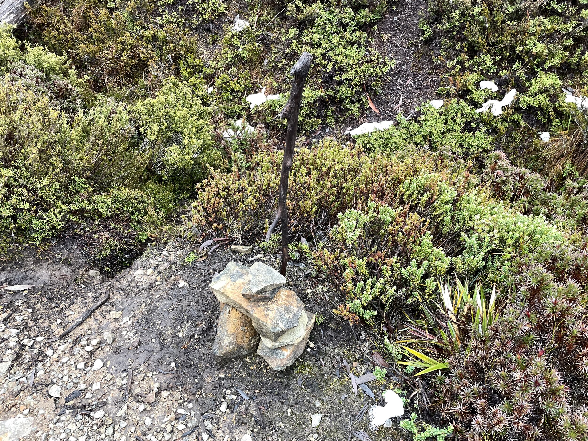
The small cairn on the Curvier Valley Track indicating the junction to the Mt Byron pad.
Leaving the Curvier Valley Track and setting off on the Mt Byron track two things were immediately obvious. One, finally I was climbing and the track was steep. And two, although there is a pad and cairns all the way to the summit, I wouldn’t be able to rely on either. The snow on the ground ensured the pad was completely covered. I was concentrating on looking for where the snow sat lower (indicating the pad underneath) as I pushed onwards. Snow was falling around me but the air was still with no wind at this stage.
The lower levels of the Mt Byron track were quite steep but easy to negotiate. I wandered through the mid calf high alpine scrub following the pad when it was visible and using common sense and reading the ground and surroundings when it wasn’t. Occasionally I would spy a cairn and get that little sense of reassurance that I was on the right path.

Snow completely covering the pad over.
As I gained elevation some pockets of scrub became denser and I was sweating in my wet weathers due to the exertion of climbing steeply and lifting my legs high to counter the snow covered scrub. I was glad to see rock start to sprinkle the vegetation as it meant I was nearing the scree field that leads to the summit. At this stage I was starting to tire a little and felt like I was going at a snails pace. A quick check of my watch showed I was actually moving at a good pace – I just felt slow!
The mixture of vegetation, scrub and taller trees finally gave way, and rising above me I saw the scree field. F#$K. It was entirely covered in thick snow. Like puffy, fluffy, white marshmallow covering everything. Not entirely surprising given it was snowing around me, I was at above 1000m of elevation, its winter and the weatherman had forecast exactly this!
Snacking on a ginger biscuit I reassessed my predicament . Still ahead of time, still warm, still prepared – lets do this! The boulders that make up Mt Byrons scree field are not particularly huge (no Mount Pelion West for instance) but some of them are big and awkward. Cover them in snow and they are bigger and awkwader! The “cairned” route to the summit was also totally non existent. It is there for sure, but all the cairns were completely hidden under deep snow. This is where I started to feel equal parts excited and scared. Whilst I wouldn’t need to rely on the cairns (I had maps, both electronic and paper) they would have made life a lot easier.
Slipping microspikes onto my feet I clamoured up onto the first boulder in the field and looked for the next closest. With each step I took I needed to first check what the snow was hiding by placing foot pressure on it but not my body weight. Sometimes the snow would give way and reveal a taller than Xing sized hole!. Don’t step there! If the snow didn’t give way but hid a rock I would climb onto it.
My progress was now painfully slow! It was like climbing in braille!
I had no visibility of what was under my feet. I would have to “wipe” the snow off the rocks I was trying to grab onto or it would give way under my hands and I would lose my grip. My midget height wasn’t helping either!
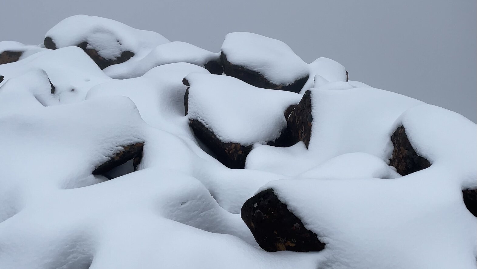
Snow hiding all the holes in Mount Byrons scree field.
More than a few profanities would slip from my mouth as I pushed upwards. The concentration needed was tiring and my brain was starting to tell me things like “you should turn back”, “who does this sh%t”, “this is insane” and all manner of other negative things. I would look at my GPS and say just another 10 meters and dispel the unhelpful thoughts. That’s one of the biggest challenges of walking alone – keeping your mind in check. Its character building.
Nothing but my breathing disturbed the air around me. It was completely still, completely white and I was completely isolated.
Checking my GPS I calculated around 80 meters to the summit. In any other conditions 80m is a hop skip and jump. But the constant re-routing due to snow making ordinarily scaled rocks impassable, meant 80m may as well be 800m. I pulled out another ginger biscuit, replaced my gloves with a new pair, gave myself a stern talking to and stiffened my shoulders. If I was going to summit I needed to lift my game as the now heavily falling snow would cover my footprints. If that happened I would have to find my way down instead of retracing my steps back. .
Digging into my dwindling energy reserves I dragged myself up another big boulder. Kicked the snow off the one next to it and started a sort of climb and drag upwards. I giggled to myself that I must have looked a right treat. Wet, snow covered and bedraggled. Like a zombie dragging my limbs upwards! I was counting down the meters. Forty, thirty, twenty, ten. And then finally the summit cairn appeared in front of me!!
Happy dance, happy dance. Ok it was more like a thank F#$K! I looked out at the views… and… there was nothing. A cloak of heavy white mist with fresh falling snow hid the existence of the world from me. It was eerie.
But hey its as much about the challenge as the views and boy had I been challenged!
A few quick snaps and it was time to make haste down the mountain. The wind had started to pick up, the snow was falling much heavier and I was for the first time feeling genuinely cold.
My plan was to take the exact same route down as it was a known quantity. I would use my hand and foot depressions to retrace my steps.
There is always the temptation to “rush” back down off a mountain when the conditions deteriorate, but that temptation can lead to mistakes and injury. I reminded myself to get down quickly but safely. Most of the descent would be on my backside as standing and descending in such slippery conditions was asking for trouble! Gradually I followed my trail back downwards, using my arms and legs to slow my slip on the larger boulders. Finally my feet slid off the last boulder and back to the relative safety of the snow covered scrub.

Micro spikes and a summit cairn - love it!
Sort of falling, stumbling and walking I returned to the little cairn on the Curvier Valley Track that I had left less than three hours before. All up, 1 hour, 40 miuntes to the summit and 1 hour, 10 minutes down. In summer when you can see the terrain and boulders you could achieve that in much less time.
From there following the Curvier Valley Track back to the Overland Track was a simple affair. The short walk from where I had left my big pack to Narcissus Hut was easy. Not only because I was back on the well maintained Overland Track, but because I had that high that only successfully climbing a mountain on your own can give you.
I am woman hear me roar 😉
The Stats.
Distance: Approximately 27km. 15km from the Visitors Center to the Curvier Valley Track Junction. 10km return to the summit. Approx 2km from the Curvier Valley Track junction to Narcissus Hut.
Time taken: 8 Hours moving time plus extra time for snacks, photos, packing and repacking my day pack.
Difficulty: Difficult in snow. Moderate in fine weather.
Type of track: Pad and cairns to the summit from Byron Gap.
Access from: Byron Gap.

The Map.
Route to Mount Byron via the Curvier Valley Track and finishing at Narcissus Hut.