Mount Oakleigh
Date: 23rd November 2019 – Summit: 1286m

With our plans for climbing Mt. Pelion West scuttled by snow, hail, rain and generally unfavourable conditions, we were more than a little disappointed. We had hiked into New Pelion Hut the evening before, made camp around midnight and spoke of the adventures we would have exploring Mt. Pelion West when we awoke. The weather gods had other plans. I had also woken with a head cold. Snow and rain, a head cold and the frustration at the lost opportunity of Mt. Pelion West threatened to wipe out all the weekend's enjoyment. A new plan needed formulating and Mt. Oakleigh was just the salve for our woes.

Mount Oakleigh from New Pelion Hut.
Gazing out across the deck on New Pelion Hut towards Mt. Oakleigh was very uninspiring. The mountain was shrouded in mist, it was drizzling and icy cold and having had only a few hours sleep the night before, our spirits were gloomy. We contemplated having a lazy day at the hut and hiding inside, but we wanted to do something this trip after all the effort we had put into making it into New Pelion the evening before. Let's walk for an hour or so we thought and if the weather is still wretched we can always turn back. It was time to put on our big girl's pants - or at least our wet weathers, pack some hot coffee and set off! I also put it out to the universe for good weather.

The suspension bridge over Douglas Creek.

The junction sign for New Pelion Hut, Mt Oakleigh and the Arm River Track.

New boardwalk across the initial grassy plains.

The as-yet unfinished bridge.
The track to Mt. Oakleigh starts on the eastern side of the New Pelion Hut, leaving the Arm River Track just after the suspension bridge over Douglas Creek. The short section of Arm River track to the suspension bridge was a boggy, rooty mess. Heavy winter rains, snow melt and regular foot traffic has combined to destroy and erode what actual track was there. Parks obviously have plans to rectify this section of track, as timber boardwalk lays off to the side of the slogged-out track just waiting for installation. Still it's only a short section we thought - how naive we were!

The state of the track. Mud, mud and more mud.

Root laden track reminded us of the DuCane Range track.

Older boardwalk sections.
Not more than a few steps after crossing the suspension bridge an old timber sign indicates the junction to Mt. Oakleigh. From here we crossed the wet and very muddy plains by way of intermittent sections of board walk, boggy single track and segments of root covered ground weaving through low level scrub. Some sections of boardwalk are relatively new where as other pieces had sunk into the sodden ground. It was still drizzling, it was still cold and the mountain was still not visible! Oh the joys!

Entering the forest canopy.

Orange reflective markers along with rusty tin cans and cairns mark the route.

The many beautiful shades of green forest.

Fallen trees and logs litter the trail.
Leaving the boggy plains behind us we entered open eucalypt forest before it quickly changed to stunning myrtle forest. Our moods lifted considerably as we were now a little sheltered from the cold winds and constant drizzle by the canopy. Every shade of green imaginable was on show in the form of tree foliage and the endless amount of moss and lichen covering the forest like an numerous shaded green blanket. We felt like we had entered a hidden garden. The track although still muddy and boggy underfoot was well padded as well as being marked with a mixture of rusting tin cans or reflective triangles. As soon as we entered the beauty that was the Myrtle forest the mountain showed herself by way of the steady upwards climb which did not relent until we stepped out on the summit plateau.

Tall Pandani trees.

Lichen and mosses abound.

The Pandani archway. Stunning!
The incline increased noticeably after entering the forest canopy as almost 450m of elevation is gained over a 2km section. Slippery, moss covered ground had us concentrating on our footing as did stepping over fallen trees and forest debris. The track wound upwards through the Myrtle forest and past some huge King Billy Pines before tall Pandani trees sprinkled the pad. I have never encountered such tall Pandanis and was remarking the same to Ben when all of a sudden I rounded a bend on the climb and was rendered speechless. An over hanging section of dense Pandani trees has formed the most breathtaking pergola in the middle of the forest! Bending to walk through the natural archway formed by these Pandanis had us musing that maybe Mt. Oakleigh might usurp Mt. Rufus as our prettiest mountain yet!

Lake Ayr.

Looking back towards New Pelion Hut.

Mt. Oakleigh's south-western edge.

A look out before the summit plateau.
Stepping out from our little Pandani passage way, the forest opened up more with the vegetation changing once again, this time to alpine scrub. The track underfoot changed from moss-covered and muddy forest trail to rockier ground. This was the first time since starting the hike that we were to glimpse above or below us. Above us the south-western edge of Mt Oakleigh was still shrouded in mist, and below us, Lake Ayr was moody. The wind was picking up again, but for now the constant drizzle had abated. Again I put it out to the universe for good weather.

First substantial cairn of the day as we near the plateau.

Out of the forest and surrounded now by low alpine scrub.

It's over there, somewhere....!
The vegetation decreased markedly in its height as we grew closer to the summit plateau. Unfortunately, this left us more exposed to the temperamental weather. The wind was still blowing ever more strongly, the drizzle had settled in and the temperature on the summit plateau was bitterly cold, we could feel ice in the air! We briefly discussed turning back, but decided we had come this far we may as well push on for a bit. Our visibility was limited by the mist settled on top of the mountain, making cairn and track spotting a bit of a sport! We knew from our Garmin inReach and map that the track would make a sharp 90 degree turn before heading west. I once again put it out to the universe for good weather. Ben was shaking his head like I was mad!

First glimpse of the initial high points cairn.
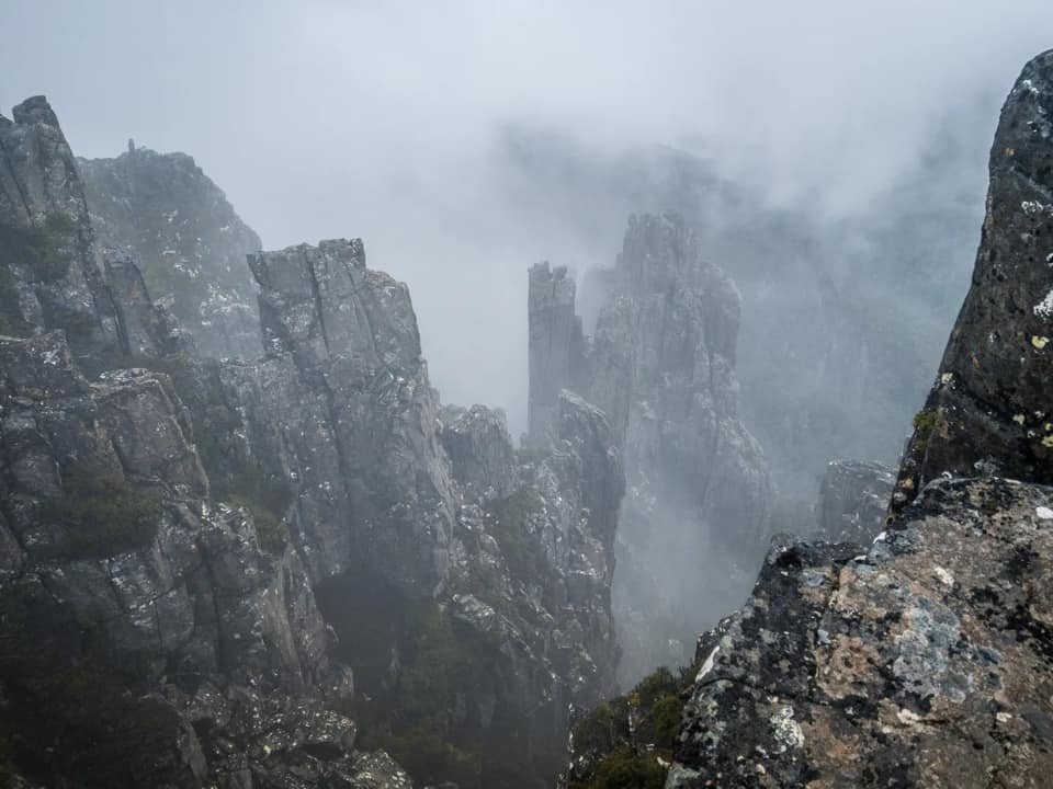
Once on top of the summit plateau, the mountain and weather decided it was time to test us - like really test us. What had been a constant but light drizzle turned to freezing cold, hard, face-pelting hail. Combined with the wind it bombarded us incessantly. Dammit - why didn't I bring my snow goggles! Ben tried in vain to take some degree of shelter behind a rocky outcrop to get some extra layers on whilst I hunted around in the almost total white out to find some cairns. For the second time in less than 30 minutes we considered turning back, but with only a bit over a kilometre left to the (true) summit, we decided to give it another half hour - after all, I still felt like the weather might come good, such an optimist! We still had one spare set of dry warm gloves each, dry layers on and food. It was safe to continue, even if it was miserable. We pressed on to the west using our map and InReach as the cairns were sporadic to say the least. Finally in the mist, we spotted the decent sized cairn which marks the initial high point.

The mist hiding the cliffs edges from us.

Through the mist heading north to find the summit.
So substantial is this initial high point cairn that you can understand why one might think they had reached the summit. However, The Abels book talks of the true summit approximately 700m to the north along the cliff line. The view-stealing mist wouldn't allow us to actually see 700m to the north, so there was nothing else to do but wander carefully in that general direction. Carefully, as we were mindful of Mt. Oakleigh's cliff face. We chose to go far enough in from the cliff face to allow safe passage even if it increased the distance slightly.
Avoiding the steep drop offs by staying slightly inland.
With no visibility of the true summit we had to rely on our Garmin InReachs to indicate the distance to the highest point and the actual highest point itself. Crossing slightly inland from the cliff line we negotiated the boggy walk northwards over low alpine scrub and rock, sprinkled with wet marsh and numerous mini tarns. Weaving a crooked path around the tarns until, through the mist ahead, we could just see a high section of ground. Make for that, we thought! By now we were actually bending forwards into the wind to try to stay upright, whilst at the same time yelling at each other over the top of the wind, about whether we could actually make the last 200m! It's OK I was yelling at Ben - the weather could still come good....
...and then - it did! The sun came out, the tap was turned off on the rain and hail, and the mountain shone for us as we touched the holy grail that is the true summit cairn!
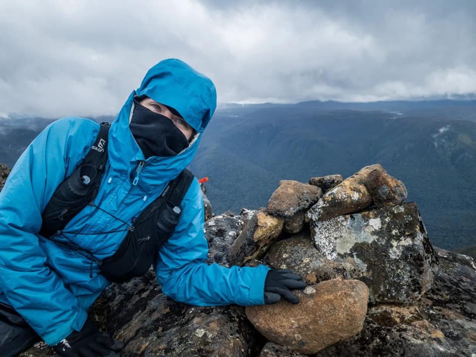
The true summit reached!

Ben looking into the mist at the true summit.

The true summit cairn and the mist starting to lift.

Looking back to where the initial high point was.

Heading south again.

Mt Achillies, Mt Thetis and Mt Pelion West from the summit plateau on Mt Oakleigh.
Our perseverance had paid off! The sun was out, the views were out and the warmth on our back had us almost jumping for joy! What was invisible in our trek north from the false summit cairn was now visible. We spent some time enjoying the summit area and then decided to head back southwards to the high point overlooking the spires to take in the views that were not afforded to us earlier. This time we used the now visible animal pads to lead us back making the return journey much easier.

Mt. Pelion West teasing us.

Sunlight and blue skies for the journey home.

The track now visible.

The substantial cairn at the initial high point.

Thinking of the day we climb the big beast across the way... Mt. Pelion West. - which we have since climbed!
What a difference some sunlight and visibility makes. We excitedly wandered back all the time soaking in the beautiful views that Mt Oakleigh was offering in every direction. Even the imposing form of Mt. Pelion West teasing us with missed opportunity couldn't dampen our now warming spirits. Another day we will come for you my pretty! Another day!
The stats.
Distance: Approx. 12.5 km out-and-back.
Time taken: About 2.5 hours.
Difficulty: Moderate. Initial incline is steep and track for the last kilometre is indistinct. The summit plateau is very exposed should the weather turn.
Type of track: Well tracked and marked to the summit plateau but then indistinctly marked with cairns to the true summit on the northern cliff line.
Access from: New Pelion Hut.

Route taken to Mt. Oakleigh (from New Pelion Hut)