Mount Thetis
Date: 3rd October 2020 Summit: 1482m

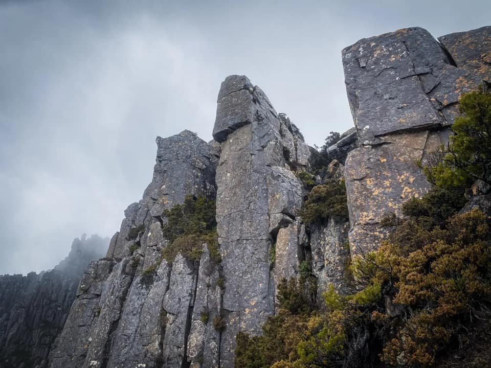
Mount Ossa behind as we traverse the boulders close to Mt Thetis’s summit.
In Greek mythology, Thetis (Goddess of the Sea) possessed the gift of prophesy and power to change her shape. Such was her power she bore a son called Achilles who was far greater than his father, Zeus. If Thetis were to rise from the seas she would stare proudly down at the mountain named in her honour for her namesake is as worthy an adversary as she might have been. What she gifts you in views she makes you earn - one giant boulder at a time.
Why not watch & read?
Please enjoy a visual trip to Mount Thetis in addition to the blog below. Whilst the blog gives you greater detail on the trip (including route information) the video allows those that may never reach its summit a virtual experience.
Having climbed Mt. Achilles and Perrins Bluff the previous year, we had constantly been trying to find both the time and a weather window to finish the trifecta and visit Mt. Thetis. We had tossed around the idea of climbing it a few weeks prior after a big snow dump in the Cradle Mountain-Lake St. Clair National Park, but instead chose to visit the new Waterfall Valley Hut and Cradle Mountain. With the benefit of hindsight, we are now wholeheartedly glad we didn't attempt it during the winter season. We would have failed miserably - or died falling into a gapping hole covered by snow!
However, it was back on our agenda and even though the weather forecast wasn't looking promising, we thought we would roll the dice and see if the predicted rain and winds eventuated. I would be leaving early during the day to make camp at New Pelion Hut - Bender would come in after work. Hiking along the Arm River Track at lunch time Friday, I was optimistic. The sun was shining and only the occasional bit of wind reminded me of the forecast. The track underfoot was boggy and muddy in places but in reasonably good condition.

Crossing the small creek not far from New Pelion Hut, a few hundred metres before the "blazed" tree.

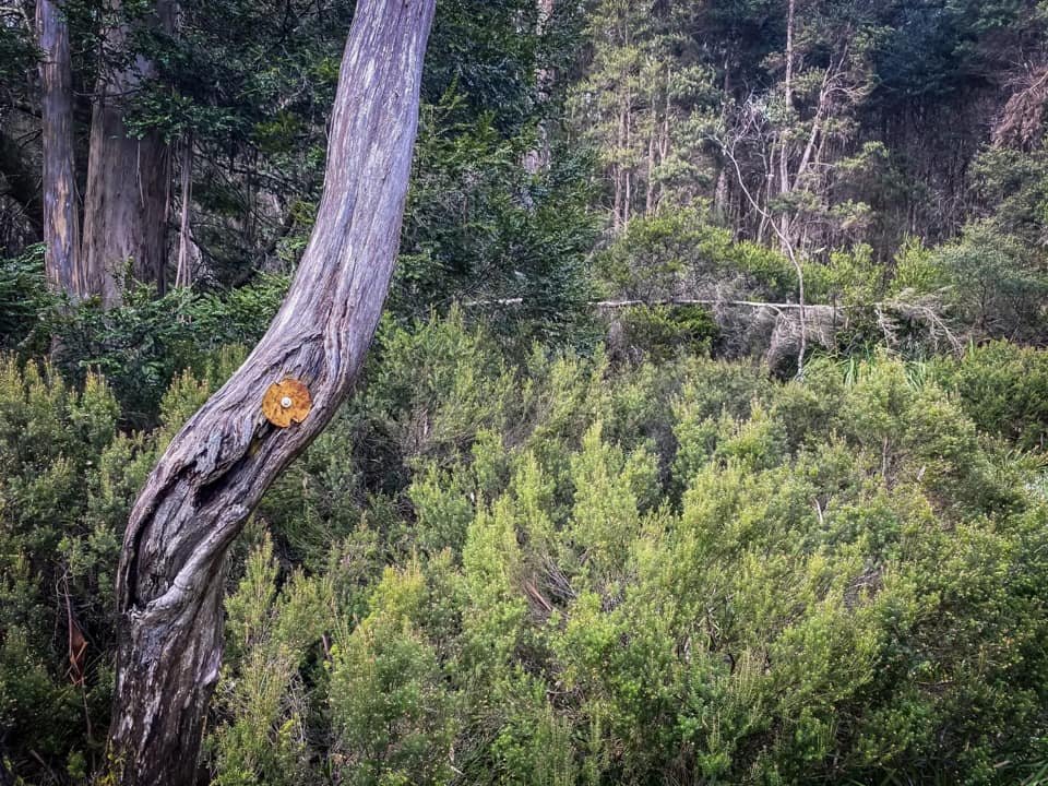
The tree with three blazes across it marking the point at which you step off the Overland Track. Note the clear area to its immediate right.
Leaving New Pelion Hut around 7:45am in the morning, we were expressing our thank yous to the weather gods. No rain or wind. How lucky were we? Our up-to-date InReach weather forecast was scheduling rain for around 2pm, but only a fraction of the falls the Bureau had been forecasting the previous few days. We had thought we would be well on our return journey by then. How wrong we were!
The "track" to Mt Thetis begins by locating a tree with three blazes across it approx. 1.4km from New Pelion Hut (200m or so after the bridge crossing). Our watches calculated 1.6km so a little further than we thought, but I located it without difficulty as it has to be the #1 photographed tree on the Overland Track ;-)

Stepping off the boardwalk onto the very faint pineapple grass pad.
Not long after leaving the boardwalk an old reflective marker confirmed we were on track.

Searching the scrub for the continuation of the pad.
Stepping off the boardwalk and into the sodden pineapple grass, I commenced hunting around for the pad whilst Bender was taking some photos. It took only moments to locate a faint pad at the edge of the grass that lead into the scrub. A few metres behind that lay a weathered reflective marker. Yippee! - we were on the track. The trail was covered over with regrowth from disuse so certainly wouldn't be called obvious, but if one concentrates enough and uses a little logic it can be followed.

The track weaving in and out of scrub. Occasional plastic markers alternate with pink tape.

The pad overgrown by scrub and cutting grass.
Occasional pink tapes assist navigation when the pad disappears.

The climb still gradual but weaving through dense pockets of scrub or climbing over fallen trees was a consistent theme.
The vague pad initially led us through sections of cutting grass and lighter scrub. Occasional reflective markers and rueben tape had us zig-zagging gently up the wide ridge heading towards the Ossa/Thetis saddle. Bender was second scouting and taking photos whilst I would go on slightly ahead to locate the next track marker or re-find the faint pad. The cutting grass was interrupted by brief sections of scrub that would continue for sometime, but the climb was only very gradual. Arriving at a small cutting grass clearing, the pad completely disappeared and so too did the infrequent track markers. Bender hunted in one direction as I hunted in the other, and eventually we found a small piece of tape hidden in the scrub which indicated the track was just buried under regrowth.

The for-now obvious pad leading through more open forest.

A weather event causing a specific section of trees to fall and die?
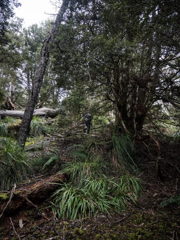
Leaving the small clearing behind us we entered more open myrtle beech forest and the walking became momentarily easier, with slightly more frequent track markers. Then once again the scrub closed in and we were doing a small amount of scrub bashing; not dense or thick, just annoying. The track eventually led into a section of forest where all the trees have fallen to the ground. A jumbled mess of dead trees not dissimilar to what you see during forestry operations. This obviously could not have been caused by man so we wondered why it had occurred? Weather perhaps?

Leaving the dead tree clearing behind us and back into the scrub we head.

Vegetation decreasing in height and the skyline opening up.

The pad completely grown over in scrub.

Occasional splashes of red paint on trees - track markers from a bygone era.
The respite of the dead tree-lined forest was brief and we again found ourselves pushing through regrowth of alpine vegetation over the track. The tree height was getting lower though and we were nearing the top of the ridge, hopeful that when we did reach the top it would be more pleasant walking.

Short sections of coral fern made for easier walking.

Coral fern pads alternating with light scrub.

Coral fern pads alternating with light scrub.

Small dots of red paint occasional act as tree markers.
The sun was shining through the cloud as we hit the coral fern that covers the ground near the top of the ridge. Here the pad was more distinct as it led us through light bands of scrub. The occasional splash of red paint on a tree became our track markers, as did the now sparser ribbon and reflective markers. There were a plethora of animal pads here so I was concentrating to make sure I didn't lead us astray on one of them. We spent the next half hour alternating between minor coral fern meadows and bands of scrub, but all the time having to actively seek out the next marker or make sure we were on track. Where markers had fallen off trees, we repaired them and replaced them.

Our first clear glimpse of Mt. Pelion West, looking ever-imposing with a light dusting of snow.
It was whilst approaching the top of the ridge that we were treated to our first glimpses of Mt. Pelion West. What a big, beautiful brute! Crusted in snow and rising above the mist it constantly commanded our attention. "Stop and look at me" it shouted from across the valley - and stop and look we did! We were moving a lot slower than normal as it was such a glorious day and the views were so mighty, Bender could hardly keep his camera down. In hindsight we were enjoying ourselves a little too much and we would pay dearly for our tardiness later.
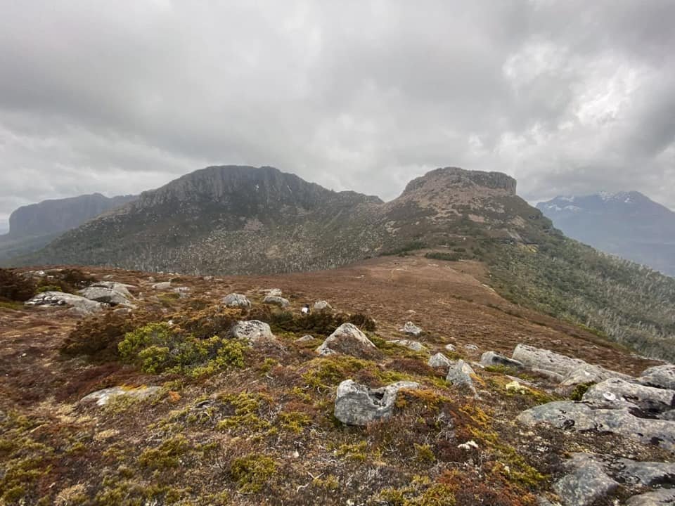
The ground beneath our feet levelled out as the views increased! Mt. Ossa, Paddy's Nut, the sprawling mass of Mt. Thetis, Mt. Pelion East, Mt Oakleigh spread out in front of us. WOW! Then yet again, the pad completely disappeared under the over grown scrub. Pushing through was simple enough and it really only lasted a few minutes each time.

Starting the cross of a surprisingly long scoparia field, with Mt Doris and Mt Ossa to our immediate south.

An unusual view of Mt. Ossa.

Paddy's Nut lit up in the sun with Mt. Thetis behind.
Stepping out onto a large scoparia marsh we now had a clear view of our destination. We realised we still had a lot of distance to cover and now the wind was picking up. Nevertheless, there was no rain falling and that was promising. Weathered old stumps with faded white markers were scattered sporadically across the expanse of scoparia and marshland. The pad was hidden amongst the scoparia so the old timber stumps at least gave a general directional heading to follow. The sun was illuminating Paddy's Nut in the distance, but Mt Thetis had ominous looking shadows flanking it. The scoparia would eventually give out to one last small section of cushion plant, which in turn gave way to more scoparia.

The never ending scoparia field.

Paddy's Nut looks deceptively close from here - but it's not!

Rounding the first raised scoparia 'hill' before continuing on towards the Ossa-Thetis saddle.

More scoparia across a very boggy marsh.

Locating pink tape hidden in the scrub at the end of the scoparia marsh.
Nearing the edge of the final scoparia field, a distinct pad led off towards our west in the direction of Paddy's Nut. However, our equally distinct pad continued south and we could make out a final stump marker where our pad led into the bush. Stopping and chatting about which pad to take we decided to stay on the one we were on for a few reasons. One, our pad continued to the same stump markers that had been present till now. Two, most of the maps/blogs we have seen have continued on this rough directional bearing until the sandstone shelves/cliffs. And three, if we had taken the western heading pad it would have to drop into the deep scrub filled gully before popping back up below Paddys Nut. Turns out our logic was right - not much farther along the pad pink rueben tape reappeared.

Breaking out of the scrub heading towards the sandstone shelves.

The sandstone shelves visible ahead.

Looking up towards the beautiful "gardens" surrounding the sandstone shelves.

Bright green marsupial-grazed lawns

Enjoying the soft, squishy marsupial cropped lawn area.
The upwards climb intensified leading us through eucalyptus and pandani. The rueben tape was sparse but the water rutted pad was distinct enough. The track wound up until we reached a small and quite pretty ledge that we would hoist ourselves above to rejoin the track.
A slight pinch in elevation placed us just below the sandstone shelves and a beautiful alpine garden area. Bright green, soft and spongy grass afforded us a few moments of faster travelling. As we crested the first shelf the obvious pad split into two. Once more we had a decision to make. The west-leading pad would no doubt skirt the sandstone shelves and save a tiny amount of elevation gain but it led into very dense head high scoparia. No thanks. So we took the fork leading further up the shelves mostly because we were also curious to see the camping area we had heard about further up.

One of the beautiful tarns on the Ossa/Thetis saddle area.

Looking towards Ossa from the Ossa/Thetis saddle.

With the wind starting to chill exposed on the ridgeline - and moments of hail too - it was time to get the wet weathers on!
Our decision paid off as the pad led us up onto the Ossa spur quickly and easily - and it was charming indeed! Soft, padded grass cover, crisp clean tarns to refresh our diminishing water supply and some of the best views of the day, including a bird's eye view of a very obvious pad leading to Paddy's Nut. But - our weather window was about to run out. A cold chill came over and the heavens opened. Rain and then hail started hitting us. It was time to don the wet weathers, stop mucking around with photos and get moving. We had the most exposed and hardest section still to do, with the worst weather.
Looking towards Paddys Nut from the Ossa/Thetis saddle. Note the distinct pad aiming for the middle of the two pencil pine clusters.

Delightful pencil pines at the base of Paddy's Nut. Mt. Thetis looming large in the background.

Sidling around Paddy's Nut.

Around the corner (out of view) we join the Paddy/Thetis saddle. Note the top of Mt. Thetis starting to disappear under mist.
Moving faster now we dropped down from the sandstone shelves and followed the well worn pad that led between two pretty pencil pine groves to the base of Paddy's Nut. The pad up towards Paddys Nut was very distinct and we had originally planned on climbing it first, but given the deteriorating weather we decided to push straight on to Mt. Thetis. Sidling around Paddy's Nut towards the Paddy/Thetis saddle we stayed low enough to avoid unnecessary elevation gain but high enough to not drop into the valley. The scree on Paddy's Nut was perfect rock hopping size for the most part, though the damp meant we were stepping with care. We were aiming at the saddle and a narrow, steep rock chute that we hoped would give us easy access onto the boulder strewn ridgeline of Thetis.

Rapidly gaining ground towards the chute we would use to access Mt. Thetis.
Climbing the rock chute towards the ridgeline of Mt. Thetis

Reaching the top of the chute. Mt. Pelion West now disappearing under cloud - not a good sign given the mass of wet boulders that lie ahead.
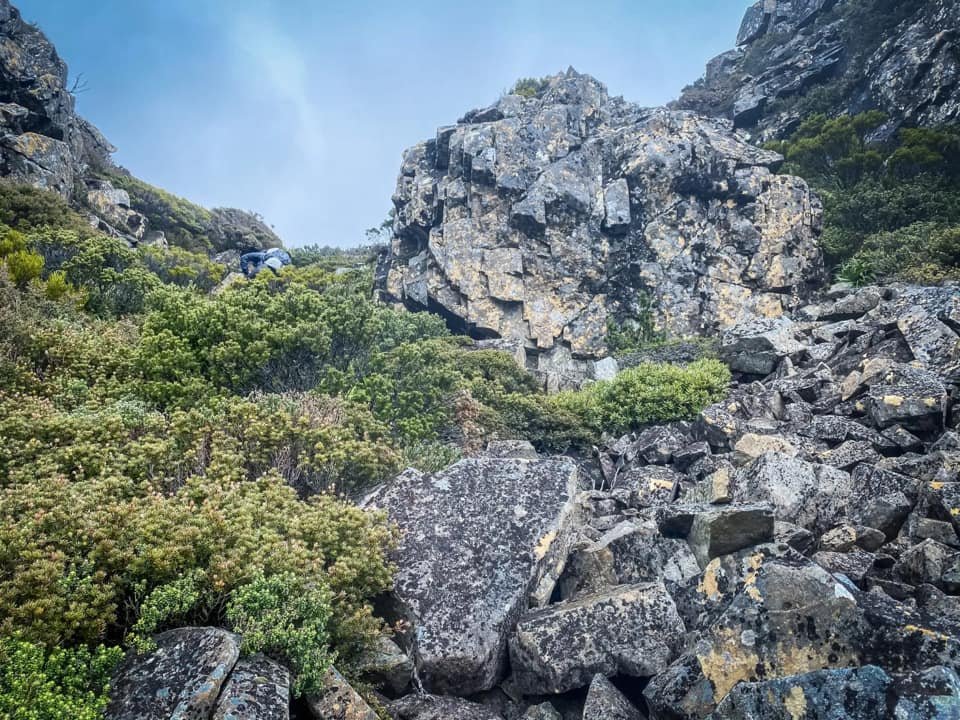
Much to our surprise I spotted cairns leading up the chute as well as a semi-defined pad. Perhaps there was a cairned route to the summit? But alas, no - other than a few misleading cairns that went nowhere at the top of the first rocky outcrop, there were no others. We followed the pad from the chute for as long as possible before it too fell prey to the gargantuan boulders that would be our miserable existence for the next two hours.

The last of the vegetation and pad before there is NOTHING but giant boulders.

The first of the zillion huge, slippery boulders that we would climb over.

Checking and rechecking our grip on the slippery moss covered rock.

Constant route changes to find easier and/or safer access points.

Not happy Jan! The weather closing in again.
The Abels states not to climb onto the ridge until much higher up to avoid lots of large boulders. Let's make one thing clear - there is no avoiding these boulders! If there was, we would have found it. High, middle or lower ground, it didn't matter. Huge boulders with even bigger crevices between them constantly had us rerouting. These monster rocks were also wet and covered in that typical black algae which offers zero traction whatsoever.
It was almost impossible to trust our grip or footing and the physical energy we were expending in rechecking our footing and grip was tiring. Bender - who is normally supremely confident on boulders and with heights/drops - even had a few "$#%@ that!" moments. I was using every bit of my mental strength to push through my fear of heights and the thin air beneath my feet. The weather gods were now punishing our earlier arrogance, believing that we had time and sunlight to waste ,and rain was pummelling us and creating giant slippery slopes that would not end well if we lost our footings.

Negotiating the constant crevices and deep holes amongst the boulders.

Zero visibility as the rain persists and heavy mist descends.

In some areas the boulders we two or three times taller than I was!

The summit area lost in the mist.

Looks awkward? It was. Smile totally faked for the camera :-p

No end in sight. Just more giant boulders. More slippery algae and more rain.
Our progress was beyond slow. Up, over, down, back, around, through, reverse. Constantly seeking an easier - or at least a safer - route. Reaching yet another gaping hole below us, I considered defeat. We still had at least a kilometre of this slimy rock torture left. I was physically spent and mentally drained. I yelled and cursed at Thetis, the weather gods and our insatiable need to put us in challenging situations... and then pulled on my literal big girl pants, fixed a determined grimace on my face and dragged myself physically up another boulder.

With relief we finally spy the pineapple grass gully.

Treading carefully through the gully but relieved to be off the boulders for a while.

Following the gully down towards the summit base.

We'd soon realise we would not be able to take the "normal" route to the summit, due to snow cover making it too risky/difficult.
After what seemed like a lifetime of slow torture, we reached the pineapple grass gully that would shelter us from the battering weather and allow us to regroup mentally and gather our reserves. Snow still lay thick in this sheltered area and we were treading cautiously to make sure there was solid ground underneath the white veneer. The summit lay approximately 500m to our west, but we knew that Thetis would still have more challenges in store for us - and she did.

Beyond the large fallen rectangular rock in the background soft snow hid gaping holes between giant boulders. We would not be using the usual route then!

Snow ledges that fell out from under you as you stepped on them.

Nearly there! After an endless fight, the final 100m was surprisingly easy walking!
On a fine day - and without snow cover - this grassy gully should be able to be followed to just below the top to avoid some of the larger boulders to the immediate north of the summit. Now though, the snow half buried some of them making picking a safe route extremely challenging. Looking further down into the gully we could see there was no way we could trust the usual route given visibility of what was under the snow cover was zero. We pinpointed the summit using our InReach and Bender forward scouted a direct approach up out of the gully using his ice axe where necessary to get himself up boulders so big even he couldn't climb them.
Once he had determined we could at least make it a few hundred metres closer, I began to traverse the snow over to him. Unfortunately for me a section gave way dropping me almost chest deep into the snow and at the same stage trapping my right foot under a rock. Honestly, a sharp series of "FMLs" were going through my head before I yelled at Bender to come dig down with his ice axe and pull me out! Dragging me free - and taking a much needed moment to calm myself down - we began the final push to the summit.
Mt. Ossa behind me rising in the mist.

The imposing form of Mt. Pelion West.

The holy grail that is the summit cairn of Mt. Thetis.
At near on 2:30pm - almost 6hr30mins since leaving New Pelion - we were finally touching the summit cairn. We were weather beaten and miserable but then for a brief moment the clouds cleared, the rain stopped and we got to see Thetis in all her glory. This is why we do it. Looking across at Mts. Pelion West, Mt Ossa, Mt Achilles, Perrins Bluff, Mt Pelion East and Mt Oakleigh... they were all there, and we had a front-centre seat. We would normally snack on the summit but we had already extended our turnaround time from 2pm to 2:30pm and we were mindful of the return journey across the sodden boulders so decided to have lunch once off the ridgeline and back at Paddy's Nut.
The worst thing about our return journey off the rocky ridge was knowing what we had in store for us. The best thing? Knowing I could bum slide down the entire mountain if I needed! Bender kept his microspikes on even after the snow covered pineapple grass for extra grip (It's not great for their lifespan, but I wanted all the traction I could get - Ben) where as I fully intended to use my backside on the way down so didn't even bother putting mine on. Slowly and carefully, we picked our way down, one large boulder at a time.

Using a small patch of vegetation on Mt. Thetis' eastern face to break the boulder climb.
Looking back up towards the ridgeline and the scrub we had used to drop some elevation and to allow us a few hundred metres of relief from the huge boulders.

The band of scrub below Mt. Thetis' eastern face.
Our progress was ever so slightly quicker now, as we knew we had to make up time or be scrub bashing in the dark... and because gravity was obviously assisting us. Nearing the last rocky outcrop, I spied a band of vegetation on Thetis' eastern face that would allow us a short reprieve from the large rocks. I convinced Bender we should sacrifice some elevation for the safety and hopefully faster progress. Our gamble paid off and we were rapidly gaining on the pad that would lead back to the chute off Mt. Thetis. Clearly other intrepid travellers desperate to get off the rocks had thought like us, as there was evidence that we weren't the first to drop onto the eastern side at this point!
Bunkering down from the weather in the chute, we pulled out our lunch and discussed our return journey. We agreed that, sadly, there was now no time for summiting Paddy's Nut - not that either of us really had the energy for more damp bouldering. It was time to just hightail it back to the Overland Track. Crossing Paddy's Nut, the scoparia fields and the coral fern would not be a challenge, as we would likely make them before light faded. If we didn't make the final forest push before dark however, we would be relying on our InReachs to navigate as the track was barely visible in the sunlight, let alone the dark.
We'd love to tell you this photo showcased the beauty of night as we completed our epic journey. The truth is, this is a shot Bender captured as he walked in along the Arm River Track the evening before. Instead the sky was grey, misty and ever darkening as we found away down off Thetis in worsening rain.
The sky remained dull as we bore down on our return trip, heads down to keep the worse of the now-steady rain off our battered faces. Hitting the finishing descent through the scrub right on dusk, we were indeed completing our day's adventures in the dark. I was leading with Bender second scouting; when the faint pad would disappear in the fading light through the dense sections of bush, Ben would check we were still on track with the Garmin. It was beyond splendid to again stand on boardwalk'd civility of the Overland Track, with only a wet 1.6km back to warm clothing, hot food and a zillion leeches to be removed.
"How lucky are we to live in Tasmania?" I commented to Bender on the trudge back to the hut. Eleven hours of challenges and I wouldn't have spent the day any other way - well maybe I would have swapped out the rain for a dry day and dry rock... ;-)
Route taken to Mt. Thetis via Paddy's Nut from New Pelion Hut (Overland Track).
The stats.
Distance: Approximately 20km return from New Pelion Hut on the Overland Track.
Time taken: Approximately 11 hours in total. We estimate the weather conditions added a good 1.5 hours to our total, as did stopping for photos and videos. The Abels states 4 hours each way from the OLT. We would say that in perfect weather, a light pack and NO stopping this might be achievable. It is more likely to be 4.5-5 hours each way.
Difficulty: Difficult. This walk should only be undertaken in fine weather by experienced hikers confident with heights, large boulder scrambling and navigation.
Type of track: Overgrown pad with occasional track markers and a handful of cairns at the beginning of the Paddy's Nut-Thetis Ridge. Completely untracked from that point forward.
Access from: New Pelion Hut and the Overland Track.
** It is very important to mention at this point that this mountain is best visited in fine weather. The wet weather that eventuated on our trip increased the difficulty markedly and our trip report reflects this. **

Route taken to Mount Thetis.