Mount Tor
Date: 10th October 2019 – Summit: 1110m+
The Abels book describes Mt Tor as "hard" and that is certainly not an understatement. If flooded creek crossings float your boat, then Mt Tor in spring is for you. If endless amounts of head high - and at times virtually impenetrable - tangles of tea tree, wattle and banksia are your thing, then Mt Tor is waiting. If infinite amounts of knee high button-grass gets your groove on, then visit Mt.Tor. If you want to earn your mountain in scratches and bruises then a visit to Mt Tor should be high on your list. For me, I love a lost in-the-bush, scrub-bashing day out. If you don't, then Mt Tor is not your friend.


There are two routes mentioned in the Abels book for Mt. Tor. The longer and somewhat more difficult route approaches from the north and is permanently available, due to the road being open to public access. A shorter and less difficult access is from the west, but crosses private property owned by Forico. The Abels book mentions in order to use this route, contact needs to be made with Forico and permission requested.
I contacted Forico and was advised by them that they are no longer giving access to hikers, unless part of a formal and registered walking group. Forico went on to mention that even then, it is unlikely that permission would be given due to the access road being in the centre of their operations. So the long way round from the North it was! Lynnda and Chris would join in for the days torture... I mean adventure...
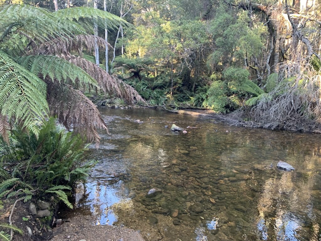

So after a very early start and a very long drive we parked on the minor gravel track off Alps Road near Dempster Creek, the first of our creek crossings for the day. A pink ribbon marked the parking area but it was obvious where the start was regardless. A short walk (approx 100m) from the car bought us to Dempster creek. This first creek was low and easy to cross, which was just as well as rivers and creeks are not my favorite part of any hike!
The overgrown 4WD track then winds along through the forest canopy for about half a kilometre before we reached the Leven River. Just prior to reaching the Leven River we peeled off to the right to locate the safest area to cross. During the dry summer months this river can easily be waded across without so much as a toe getting wet. That was not the case for us in early spring!


We spent a few minutes looking for the shallowest and safest area to cross. Swollen from recent rains and snow melt, the river was deep and fast flowing with a reasonably strong current. It reached mid-thigh level in some parts as we crossed. Lynnda opted just to wade across, boots and all! Chris and I didn't relish boots full of water a few hundred meters into the trail on what we already knew was going to be a tough day.
Chris had planned ahead and bought Crocs which he wore in the water to cross, I was down to my bare feet. Using our poles to anchor us against the current and facing upstream we pushed our way across to the other side. A huge thanks to Chris and Lynnda for getting me safely over when I had decided it was too deep! To add to this early challenge the water was freezing cold! A quick minute to dry off our feet, pop our boots back on and we were again heading off down the 4WD track. We would soon cross another small creek and that would be the last water source for the day, something to keep in mind if hiking in the heat of summer.


The 4WD track wound in and around the forest running alongside the Leven River for a kilometre or so. The track at times was covered in fallen trees and debris. We knew from our maps that the track would turn naturally to the left and head inland whilst at the same time begin to climb higher. Just past a very large fallen tree (that we had to go well off track to get past) the track took a sharp left and we started to gain some elevation. It was all very easy walking at this stage - easy and pretty.


As the track climbed higher the terrain under our feet changed. What a few kilometres back had been soft forest floor changed to rocky trail. It was almost at the base of the mountain that we got our first glimpse of Mt. Tor but only for a few moments before it disappeared again, as we were enveloped by canopy. A little further along the track leveled out and we took an obvious left hand branch which led directly to the base of Mt Tor.


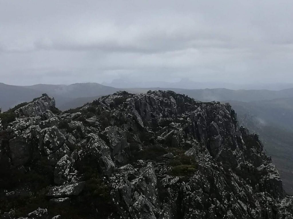
A few hundred metres along this now very rocky trail we sighted a prominent cairn marking the junction at which we would enter the scrub proper. This one cairn and the faded piece of pink ribbon behind it would be the last navigational markers we would see until close to the summit plateau! What once could have been a faded pad has long since become overgrown or disappeared completely from infrequent use. The scrub was a mixture of small pockets of button-grass and reasonably high alpine heath at this point. The incline was increasing rapidly now, and combining that with the vegetation we were working hard for the first time in the day!
The button-grass and low heath disappeared quickly and changed to head high, tangled masses of thick scrub. So dense at times that if one of us was a few metres too far in front, we were not visible to the others at all!


Now buried in thick scrub we had no line of sight above us to the summit and none to either side or below! Relying on our compass bearings we pushed on. Looking low to the ground we searched for rocky creek beds under the scrub as generally the scrub is less intense over rock. Small pockets of rock also allowed some breathing space from the ever suffocating bush. From below on the track we had noted some boulder outcrops three quarters of the way up the ridge and I was hopeful of using those as a reference point. We harbored a few reservations about how steep the boulders would be upon reaching them and if they would be passable. Turns out, whilst they were steep, they were entirely manageable and a lovely place to snack and regather some energy for the next bash!
After a short but much needed rest it was back to pushing through the scrub, at times needing the force of our entire body weight just to make a few steps of progress. There was more than a little swearing and cursing going on and a whole lot of tripping and falling over! Progress was slow and tough.


We had made reasonably quick time whilst on the 4WD trail but our progress had slowed considerably through the dense bush. Almost every step required pushing the ever encroaching trees out of our way, only to be hit in the face with a stray branch or to trip over low laying vines and vegetation. It was a relief to reach a small rocky outcrop that we would climb up and squeeze through to bring us a measure closer to the summit plateau. I got a little excited after climbing out as we could see daylight - meaning lower scrub and one lonely little cairn! The excitement wore off exactly 30 seconds later when we discovered the lonely cairn had no other cairn friends and merely indicated the entry to a sea of button-grass.


I should mention Lynnda hates button-grass. Mix button-grass with intermittent patches of head-high alpine heath and it is even less fun! After ticking Recondite Knob off I don't have a huge amount of love for button-grass fields either! However, on a positive note we were finally out of the sight-stealing forest and now had skyline! We would begin to cross this vast button-grass and tea-tree moor, contouring around a ridge of low-lying, but difficult-to-climb rock beds. Our first sight of the summit since the 4WD track was now ahead of us.


From here we began in the direction of the summit using small rock fields to break up the knee-killing button-grass. At least the button-grass was not relentless to push through like the previous head-high scrub. So far we had enjoyed a lovely spring day and sunshine. Of course now the mountain decided to show us we were here at her mercy and the weather was gradually worsening, with mist rolling in and gentle rain beginning to fall.


Gaining height on the summit we steered clear of its haggard rock face and kept ourselves on the heath-lined ridge. This ridge gently slopes away from the rocky eastern side of Tor and changes to low-lying lemon-scented Boronia. With gentle drizzle now falling the scent of fresh lemon was heavy in the air. As we drew closer to our goal we could see the view-thieving mist descending faster.


Finally Mt Tor's somewhat understated summit cairn was within our grasp. A hard earned mountain with a very underwhelming finish in the mist! It had taken us just over 3.5 hours of scrub bashing to claim it but the job was done!
After another quick snack and a hot cup of coffee it was time to get off the mountain as the rain was increasing. We had discussed changing route on the return journey and decided that it was worth a try. The scrub was no doubt horrendous anywhere on Tor so we had nothing to lose - right?


With tired bodies and minds, we set off veering slightly more to the east than we had come up. The scrub was just as dense as the more western approach and we did have to negotiate some small but tricky cliffs. That said,the dense scrub was at least protecting us from what was now miserable weather! We had no visual bearing of any landmark at all in the scrub and so we were relying heavily on our compass bearings and GPS. It was a matter of just keep pushing.
After another few hours of pushing, free-falling and - in my case, face planting - through head-high scrub we were finally back to the small section of button-grass just above the 4WD track. It was now a wet walk along the trails back to the Leven River. I'm not sure if it was because we were all a little beaten up, or because we were all drenched through anyway, but this time none of us were precious about getting wet up to our thighs and we just marched on through the river! It was time to hit Maccas, inhale the coffee and reminisce about a long, tough but very rewarding day!


The stats.
Distance: 16km return.
Time taken: 7.5 hours return, including lunch and other breaks.
Difficulty: Hard. Almost completely un-tracked and dense, head high scrub makes navigation difficult. Physically challenging from the perspective of pushing through endless scrub. Good navigational skills are a necessity.
Type of track: Old forest road initially then completely un-tracked. Over time the pad has covered over and only four cairns remain on the entire track.
Access from: Alps Road.

Route to Mt Tor