Mount Tyndall
Date: 7th March 2021 Summit: 1179m
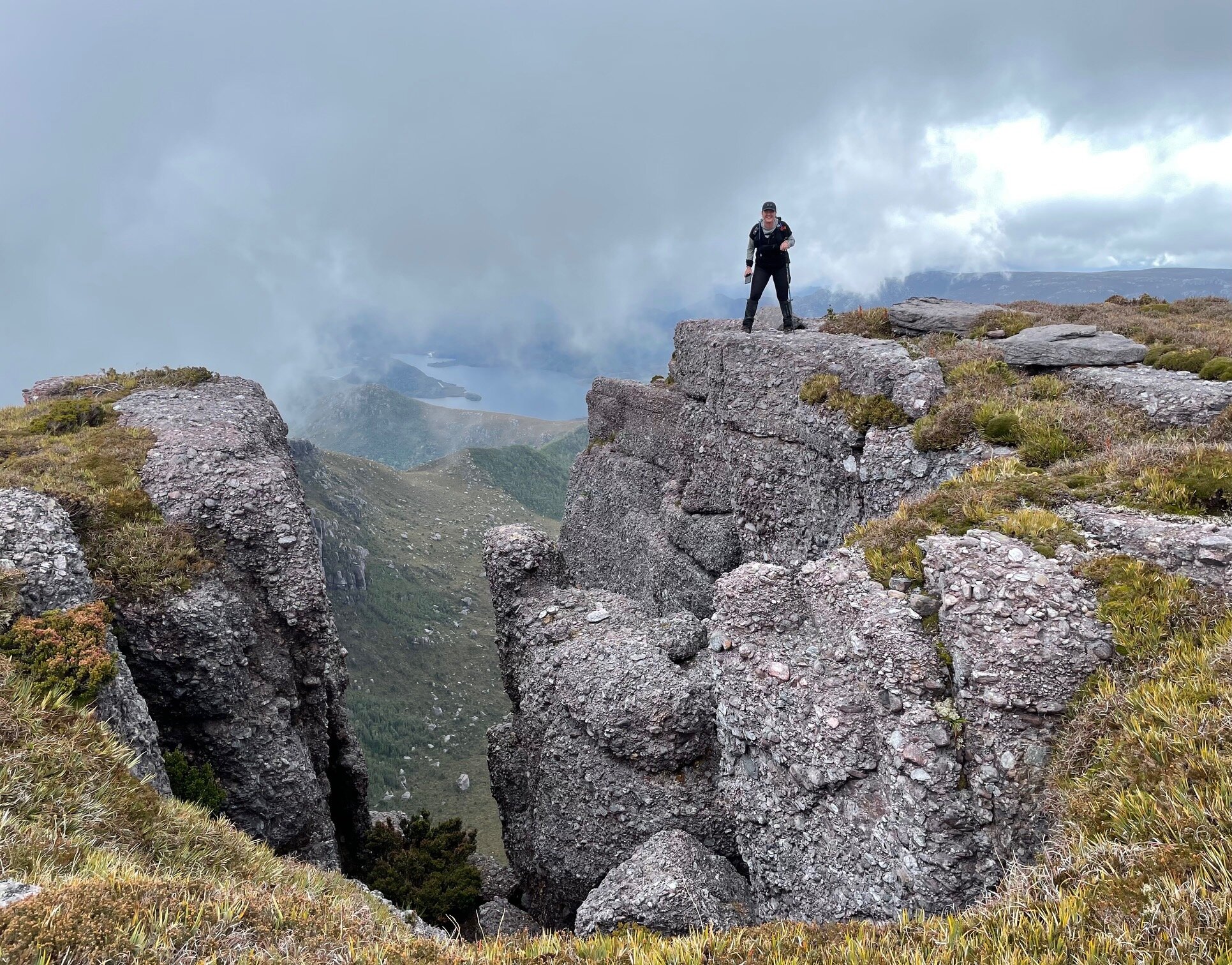
Natty standing on Mt Tyndalls rocky edge.
Although I would walk within a few hundred metres of its summit, Mt. Tyndall would be the last mountain I would climb on this March long weekend, after climbing Mt. Geikie and Mt. Sedgwick first. My friends Haydyn and Nattie would be joining me for Mt. Tyndall, I was leaving it until the walk out. For the purposes of this blog, I begin our trip report from the car park off Anthony Road, where most people will climb Mt. Tyndall from.
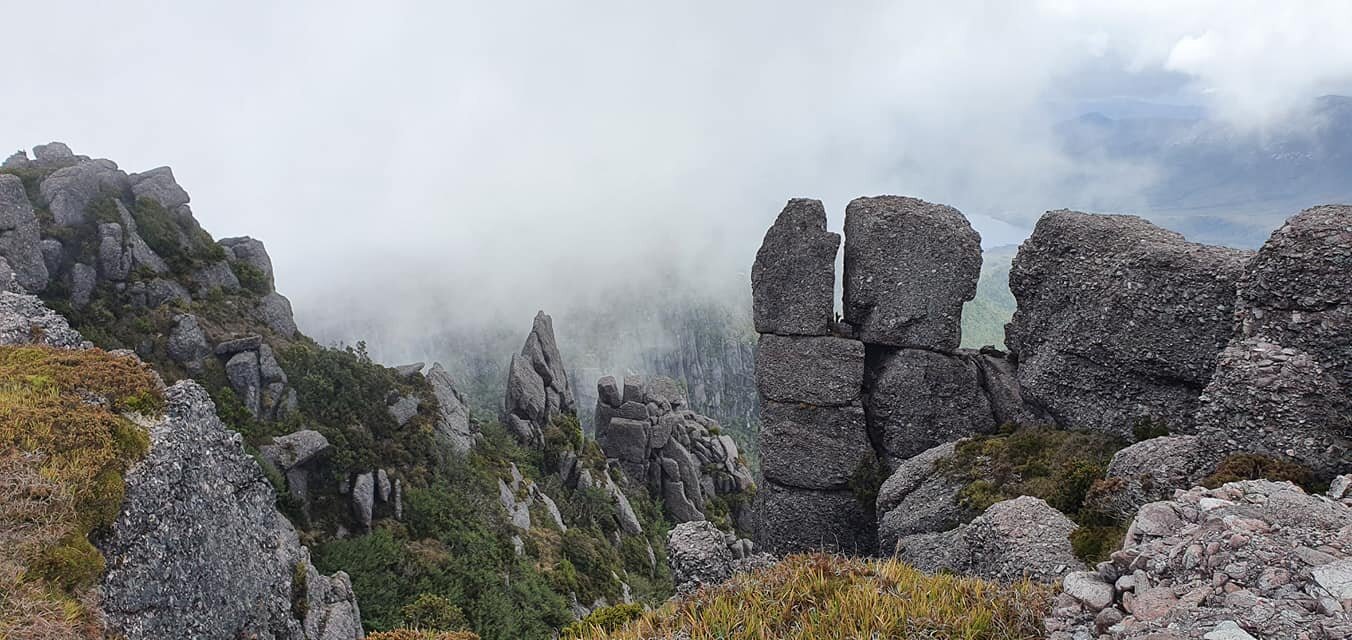
Spectacular rock formations. Photo Credit: With kind thanks to Haydyn & Natalie Bevis.
Why not watch & read?
Please enjoy a visual trip to Mount Tyndall in addition to the blog below. Whilst the blog gives you greater detail on the trip (including route information) the video allows those that may never reach its summit a virtual experience.
We decided to car camp trackside the night before as we wanted an early start. The sun had well and truly set as we pulled onto the gravel parking area off Anthony Road around 9pm. Two cars were already there, unsurprisingly, as we figured we would have company of sorts over the long weekend. Alarms set, we crawled into bed. Peaceful slumber eluded me, however, as the highway seemed to have regular and constant trucks traveling along it throughout the night.
A bridge, a few creeks and a windy gravel road.
Stepping around the bright orange boom gate that prevents vehicular access further down the gravel road towards the trail head, the sky above was gloomy. We were hoping it wasn’t an sign of weather to come - our trusty Norwegian weather man was predicting fine weather so we weren’t too worried - yet. Just past the boom gate, the old concrete bridge came into sight, water flowing fast beneath it.
If not for the boom gate the road would have been entirely drivable even in a 2WD car. Mind you, at less than one kilometre, it doesn’t add much to the overall journey, and gave our legs time to wake themselves up before the real hiking began! Walking the road was easy and even the few minor creeks flooding across were easily negotiated without even wetting our toes! Make sure you take the sharp left about 600m in that has a small wooded sign labelled “T67”.
It‘s mud time!

The muddy single track from the sign in box onwards. Photo Credit: With kind thanks to Haydyn & Natalie Bevis.

The warning sign at the start of the track. Photo Credit: With kind thanks to Haydyn & Natalie Bevis.
Even without the recent rainfall, the Mt. Tyndall track is known for being a bit of a bogfest at the start! Bender signed in at the log book, while I dived right in. With mud like this you may as well just take the plunge from the get go and get it over and done with. In some spots the mud squelched up to my knees almost. It smelt peaty and earthy, and was lined on both sides by scrub. With my pack feeling heavy on my back, I was hoping the whole track wasn’t like this.
Tea tree corridors.

Natty making her way upwards. Photo Credit: With kind thanks to Haydyn & Natalie Bevis.
The cutting grass lining the muddy track quickly disappeared, giving way to over-head high corridors of mixed scrub including eucalyptus and tea tree. The scrub was actually useful to stop us sliding over in the slippery mud, as well as giving us hand holds to pull ourselves up. Already the incline was increasing steep. I always feel a bit claustrophobic in really high scrub, so was looking forward to breaking free of it sooner rather than later. It was obvious the track had seen plenty of use in recent times but it was still a tad overgrown in parts.
Breaking free but still climbing up.
I was very happy when the scrub lowered and I could feel fresh air on my face again as we climbed higher still. Having a clear line of sight upwards was both a blessing and a curse though, as we could now see there still a bit of work ahead of us! Mud gave way to rock and the occasional cairn now assisted with navigation, although from here on in they were barely necessary.
Levels and boots.
The track would briefly level out only to then climb again - then repeat. Above our heads, the mist still hung heavy and the wind was loud. It was roaring and sounded positively horrible up top! The great thing about having a Garmin InReach is that we can get up-to-date weather forecasts for our exact location, so we did a quick wind check. It was supposed to swing from the south-east to south-west over the course of the day and would eventually ease, so we would be largely protected near Lake Tyndall for camping, but exposed briefly on the way there. Nothing we haven’t done before so on we pressed!
The rocky track now veered right before the plateau and a small boot washing station appeared. It perhaps is a temporary measure until PWS can put in a more permanent installation closer to the trailhead, as it equated to no more than a scrubbing brush hanging on a piece of rope off a tree by a very small creek. We keep our boots meticulously clean anyway, giving them a thorough scrub after every trip. In part because we criss-cross the state regularly bushwalking in different regions, and in part because we want our gear to last. But we gave them another clean regardless, then climbed the small rocky ledge opposite and continued on.
The plateau.

Mist hiding what would normally be spectacular views.
Stepping out onto the plateau we were happy to find ourselves in the lee of the wind, but were disappointed at the thick, wet mist that covered everything including views to the summit area. Lucky we were climbing it on the way out in a couple of days - a chance for the weather to change!
The morning after, the morning after.
Dear reader, with the beauty of the internet we now fast forward to Monday morning 48 hours later, to continue our trip to the top! We would meet our good friends Haydyn and Natty at the plateau below the summit before ascending together. As it turns out we also got to have a little ’fan moment’ for another of our friends and famous YouTuber Lucas Chamberlain, when we ran into his mum!
Returning to the plateau a few days later we met up with our friends and left our big packs on the main trail at the 1110m contour. With only a few hundred metres of easy walking between us and the summit, there was no use dragging big packs up. I wanted to head towards a large cairn in the distance that had a pad leading to it but was outnumbered by the others. They just wanted a straight up and back ascent. They felt the cairned track probably led to the climbers caves further east.
Up the guts.
Stepping off the path we headed north east. The summit lay up behind some small rocky knolls blocking our line of sight. The walking was easy, if winding. We wound around all the delicate cushion plants as these gorgeous flora really don’t recover from being stepped on. Other than a gentle upwards climb, there was no difficulty at all reaching the summit area. This is where the fun then started!
High point, where art thou?

Views opening up from the summit plateau. Photo Credit: With kind thanks to Haydyn & Natalie Bevis.
So The Abels mentions the trig point being marked with a concrete pillar. A visible rocky outcrop half way to the trig overhanging the precipitous eastern side looked higher, and we noted Rock Monkey had visited this point as well as the trig. Our various GPS maps claimed a semi-random spot on the summit escarpment was the highpoint! Best visit all three, just to be sure!
The dodgy rock outcrop at the very edge of the escarpment was not Haydyn’s favourite. He sat and shuffled across until he could reach his fingers onto it. Natty and I jumped the gaps in between the boulders to stand on the high point. I only lasted a few seconds but Natty was in her element. Haydyn was too nervous to even take a photo of us - he wanted us off it!
The trig.
Even though the mist still blocked much of our view south, the views to our north and east opened up nicely. Distant mountains and nearby rock formations dominated. We enjoyed some time soaking them up before visiting our third and last high point - a random rock on the escarpment! All three of our GPS devices had us right on the trusty triangle marker. We all agreed we could now safely consider Mt. Tyndall “bagged” and begin the trek back down the mountain.
Home time.
Our tired legs jolted down the steep descent rather uncomfortably as we made our way slowly back to the car. The track is particularly slippery in places on the descent, so care needs to be taken, as does with navigation. We would take a second, very obvious offshoot from the main track on the way back.
It appears that a lot of people have done exactly the same thing, but being less than 20m north of the main track it was a matter of simply crossing back onto it. The car park was packed when we returned, which wasn’t a surprise given the amount of people we had passed in our three day holiday.
But most importantly, Haydyn and Natty had come bearing gifts - cold Coke and Salt and Vinegar chips! The best! You guys are invited again!! ;-)
The stats.
The stats.
Distance: Approximately 6km return from the car park at Anthony Road.
Time taken: Despite a pretty slow pace for photos, etc. we were at the plateau below the summit area comfortably within two hours. Another half hour from there to the summit. The return journey back down to the car park was naturally quicker, so a return trip is entirely possible in under five hours.
Difficulty: Moderate. Though a fairly short distance, the track climbs upwards steadily along almost the entire route. The track, though mostly obvious, does branch out in some areas (we ended up on an alternate track on the way back down) and a fair percentage of the track is muddy or slippery, particularly at lower elevations. Like most mountains on the west coast of Tasmania, the Tyndall Ranges are very exposed to the prevailing and highly variable weather conditions of the region. Be prepared for rapid changes of weather and don’t hesitate to turn back if conditions deteriorate.
Type of track: For the most part the track is obvious. Some cairns assist with navigation closer to the summit plateau. A handful of braided tracks and rerouting has occurred, but otherwise an easy to climb in fine weather. No formal track exists from the plateau to the summit, though a faint pad does run between various points of interest across the expansive summit area.
Access from: Anthony Road.

The route taken to Mt Tyndall.