Mount Wedge
Date: 28th June 2020 – Summit: 1147m

Descending from Mount Wedge
The Abels describes Mt. Wedge as a "relatively easy foray into the southwest". Our legs were weary from a tough day out in the snow climbing Snowy North the day before, and as such we were looking forward to an easier, scenic wander. We knew from looking at maps that it would be a relatively short but very steep day out. The weather gods blessed us with an amazing winter's day, and so we took our time and immersed ourselves in the magical views on show.
Why not watch & read?
Please enjoy a visual trip to Mount Wedge in addition to the blog below. Whilst the blog gives you greater detail on the trip (including route information) the video allows those that may never reach its summit a virtual experience.
We had a big weekend of hiking planned. Our plans included Snowy North on the Saturday and then Mt. Wedge on the Sunday. Car camping in the Mazda on both the Friday and Saturday nights would allow us to sleep track-side and enjoy early starts. We decided to camp along the service road near the Mt. Wedge sign-posted track. We had tentatively arranged to meet some fellow walkers for the hike, but as we had no reception we didn't know if they were still coming. Step off was a bit after 7am.

The "official" track start just off Gordon River Road .

John and the crew heading back through the cleared transmission tower section. (Photo taken on return journey)

The service road where the track proper starts. Mt Wedge rising in the distance. (Photo taken on return journey due to darkness at the start of the day)

The start of the track proper off the service road alongside the transmission lines. (Photo taken on return journey due to darkness at the start of the day)
There are two possible start points for the Mt. Wedge Track. The first and “official” start point starts at the Mt. Wedge Forest Reserve car park, 43km west of Maydena. It includes an interpretive nature circuit, enters a transmission line clearing, crosses a service road, heads eastwards along a gravel road and then joins another signposted track junction for the beginning of the track proper. We decided to skip the first 1.2km and just start at the track proper.
Stepping off the service road onto the track.

Initial progress in near darkness.

The morning sun trying (and mostly failing) to push through the dense forest canopy.

Collapsed footbridge we had to get around in the dark (photo taken on the return journey)
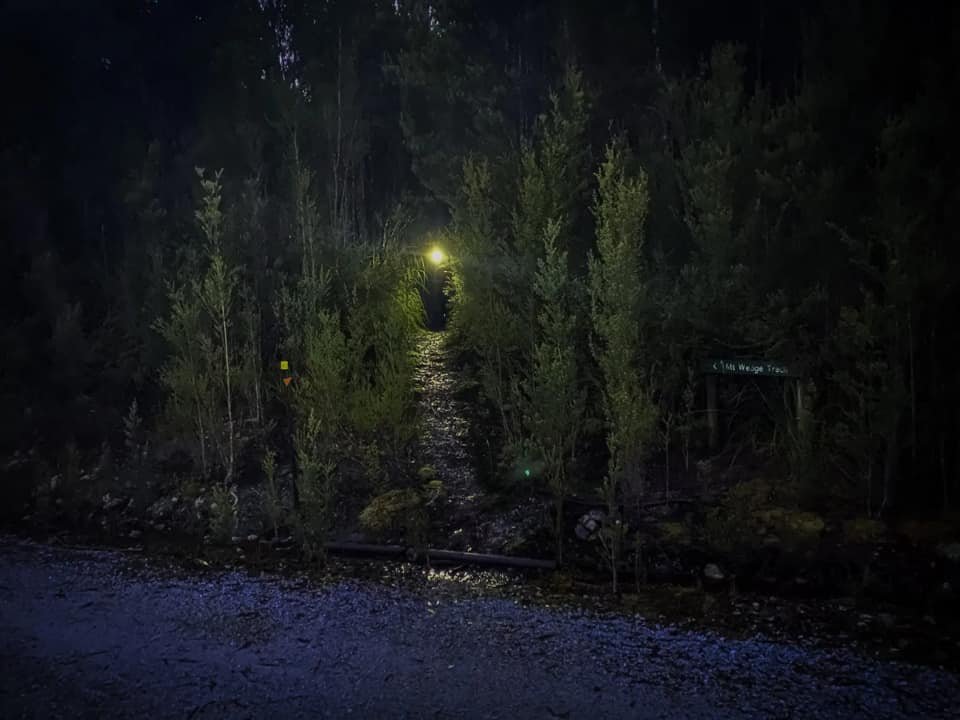
Leaving the gravel road at the signposted track junction, we stepped onto the softly padded forest floor, the scrub along the track encroaching just ever so slightly on the track. It was dark and the only light we had was from our head torches. The thick rain forest canopy meant that even moonlight wasn't getting through. Reflective markers made navigation easy for the first 50m or so and then they promptly disappeared.
The darkness made searching for the next marker a little harder than it would ordinarily be. We could hear a small stream running along the eastern side of the track, but couldn't see the water in the darkness. A glance downwards located a small collapsed timber and wire bridge lying in the creek bed. Ben was all for crossing it anyway but we instead located an easy crossing point about 5 meters to the north of the bridge and it was a simple matter of a few steps and we were standing in darkness on the other side. Once again the reflectors were non existent but we could make out a reasonably obvious pad below our feet.

Easy walking through open forest.

The sun starting to push through.
From here just a few minutes from the start of the track, the climb began! The track was now obvious, and led through delightful rain forest and old growth eucalypt. Even without the now frequent reflective markers, finding our way along was easy because of the well-defined path below our feet.

Rays of orange light touching the lichen-encrusted trunks of myrtle, wattle and gum.

The pad is obvious and easy to follow for most of the track.
We weren't sure if it was as steep as our legs were feeling it, or if it was because of the huge day we had had the day before, but we were both feeling the pinch in our calves from the incline. Other than the steep going, the walking was very easy and the path leading upwards clear and wide. No scrub bashing, unlike the previous day. Large logs had been cut through, so there wasn't even any log climbing. Bliss!
The uphill climb had little to no relent. When at times it did level out, it was only for brief moments before rising again. With approximately 800m of elevation gain over 2km, Mt. Wedge gives Drys Bluff - which famously has over 1000m to its trig point (and even more to the actual highest point) over 3km - a run for its money! We had commenced the day's walk with our full wet weathers, which we promptly stripped off about 30 minutes into the hike as we were working up a sweat fast, and the path was wide enough at this stage we weren't brushing against wet scrub.

Damp and muddy conditions on the track as we gained elevation.
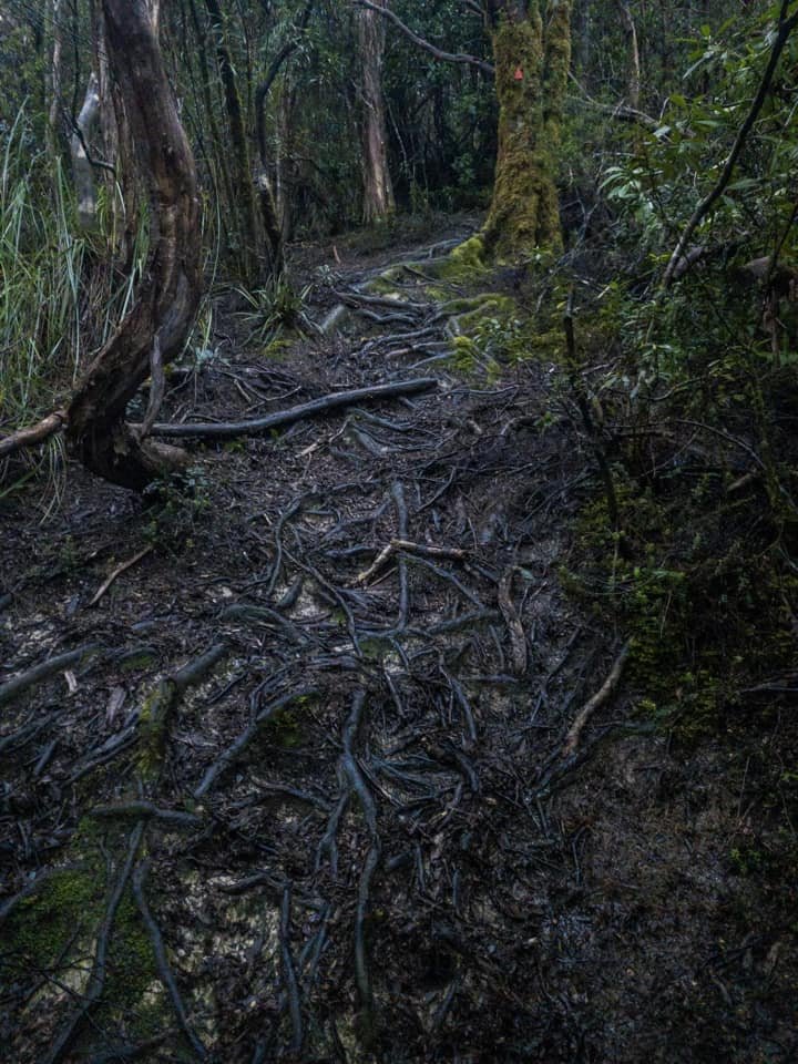
No lack of eroded roots either. Watch your step!
Even after the sun eventually rose and we were able to switch off our head torches, it remained dark under the forest cover with the track winding in and around all the time following the ridge line up. We were both looking forward to when the track would turn more easterly, as according to the map contours, it would flatten out just marginally!
Reaching the gentle curve of the ridge that would lead us east-sou-east towards the summit area, the forest temporarily opened up a little to allow some light through and the steep incline ever so slightly leveled out. The track, whilst still wide and easy to follow, now became quite boggy, with thick mud underfoot in places. The mud was interspersed with tree roots and gradually we noticed rock making an appearance too.
The sassafras and myrtle gave way to a section of tea tree and pandani, and the steep climb recommenced. The terrain under our feet had changed from loamy forest floor to a root-filled and slightly water-logged creek bed. We discussed whether erosion on the track had turned it into a running creek bed, or if the track had been cut along an old creek bed... probably both!

Definite track erosion with plenty of roots to clamber over.

The understory vegetation closing in on the track.
Next, we entered a section of forest that was mostly cutting grass and lower alpine vegetation like mountain rocket and boronia. Here the scrub was almost entirely encroaching on the track, but was shorter and we had the beauty and warmth of the sun on our faces, even though the damp, encroaching scrub had wet our clothes.

First views of the magnificent Sentinel Range as we popped above the tree line.

At this point, we knew we were in for a ripper morning. Clear skies and picturesque fog filling the valleys and lake basin.

Looking north-east towards Mt Field West, Mt Lord and Florentine Peak.
We had been walking for 1.5 hours, taking our time and enjoying an easier day out than is our norm, when we popped out from under the cover of vegetation again, but this time to views. Amazing views. Stunning views. Maybe even jaw-dropping views. Looking behind us we could see across to the Sentinel Range, appearing to float in the low cloud. We just make out the basin of Lake Gordon off to our north and even as far as the Mt. Field ranges. Sunrise, mist, clouds, day break. That moment reminded us of why we do what we do (... and justifies all the early starts too! - Bender).

Seeing what's to come... the climb gets steeper.

Looking north-ish over the ridge line we've walked up so far.
Whilst we could have happily embraced the views opening up below us all day, we were now eager to climb higher and greedy for the next breath-taking view. Looking ahead, we got the first glimpse of the small dolerite ridge and gully that we would access the summit area from. On first appearance, looking up, it was a little daunting. But as is the generally the case, whilst looking ahead there seemed no safe passage only for one to open up with each step drawing us closer. It was now we heard voices below us, and guessed that our fellow hikers had arrived after all.
The elevation increased once more and the path turned to shale before a rock path that was part hiking, part climbing, led us to the narrow ridge section that deposited us to the flatter, open slopes of the summit. Cairns led our way up the narrow ridge, but there were a few minor false leads to be mindful of.

The morning sun finally making a go of it.

Coming up around the first dolerite outcrop.

270-degree views from the first dolerite outcrop.
Cresting the narrow ridge, ice began appearing on the rocks leading towards the summit area. The views behind us were once again nothing short of stunning, and it was hard to not turn and gape the whole time! The ice and then light dusting of snow completed the winter wonderland, and once on top of the ridge we got our first glimpse of the trig point.

Xing taking appropriate care over the slabs of icy rock.

(I should probably be offering a hand here, rather than taking photos. But it's a cool photo, eh? - Ben)

A little old snow lingering as we neared the summit.

Enough ice to require serious care with each step.
Although the sun was still out the rounded summit, was totally exposed and we could feel a chill as the wind was picking up. We made haste to the summit, as it was becoming obvious we were not far off losing our pristine conditions. After enjoying the views below us, I left Ben to take photos and headed back down from the trig point to the nearby helipad, to pop on some extra warm layers and enjoy a sip of coffee.

The track flattening out as the summit is reached.
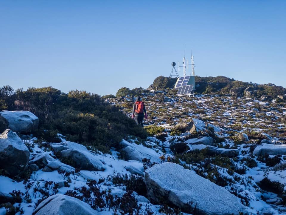
Communications equipment and the trig point now in sight.

Looking north from the summit, down at the helipad.
A short time later our fellow hikers popped out onto the summit plateau. It was lovely to meet up with John Ralph at Ascent Fitness who got me into Abel bagging a few years ago. It was after joining one of John's urban walking programs, that he progressed me to climbing my first Abel. Along with John was Simon - who has more than a few Abels under his belt - and Vivienne.
Alas, the cold had well and truly set in. Mountains and the weather have a way of always reminding you who is boss and how temperamental they are, so it was time to hot foot it back down. Well hot foot it down slowly, due to the inclination of the descent combined with the frost still covering the rocks. There was definitely a need to stick low to the ground until we were back under the canopy of the forest.
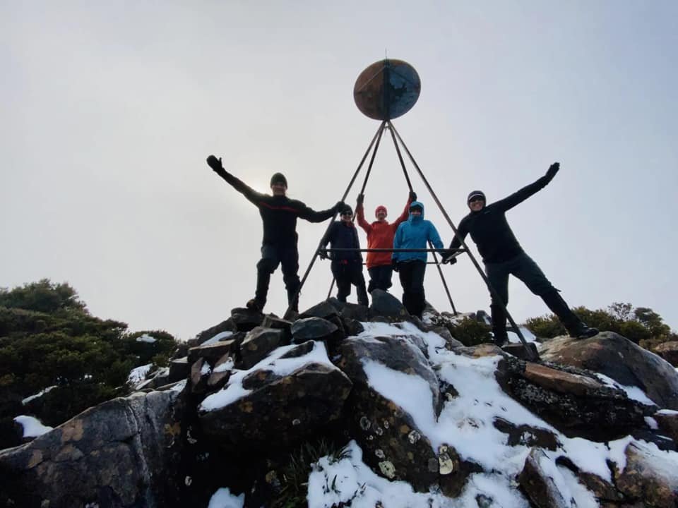
The obligatory summit group pic.

The South West World Heritage Area at its absolute best. Looking north-west across the Sentinel Range with Lake Pedder behind.

Looking south-west down to Lake Pedder and the Western Arthurs.
It was surprising to pass so many fellow hikers heading to the summit on our descent - it is clearly a popular walking track. Perhaps because of its easy access, well maintained track and short duration. Clearly the steepness doesn't turn people off and nor should it. The effort is entirely rewarded when standing on what feels like the top of the world.

Following the ridge line back down to the road.

Even though the mist did hide a bit of a view, it made everything feel just that bit more magical.

John negotiating the rockier sections of the track on our descent. Note the layer of low-level cloud around the top of the Sentinel Range.

Looking down on the crew from atop the dolerite outcrop mentioned earlier. Ben just couldn't help himself.
After reaching the forest cover the descent was quick - in part due to slippery mud underfoot causing a little slip-sliding. All too soon we were back at the car and the weekend was drawing to a close. John and the crew from Ascent Fitness were heading for a look-see at the nearby peak Tim O'Shea. We were heading straight to Maydena for our traditional post walk hot chips.
The stats.
Distance: Approximately 7km out-and-back.
Time taken: About 4.5 hrs, including numerous stops for photos, videos and snacks at the summit.
Difficulty: Easy for navigation and moderate for incline.
Type of track: Well-tracked and marked single track with reflective markers, ribbons and cairns to the summit. Expect plenty of roots, rocks and a bit of mud.
Access from: Access off Gordon River Road. Note: We started at the nearby service road instead of the "official" start. The official start crosses the service road approx 1.2km down the road.

Route taken to Mt. Wedge.