St Valentines Peak
Date: 15th September 2019 - Summit: 1107m
St. Valentines Peak is not only the most north-westerly Abel in Tasmania but - in our view - one of the prettiest to wander along. With an easy to follow and clearly marked track, an assortment of terrain and vegetation and an up-and-back time of under 5 hours, this Abel is sure to please everyone from Abel baggers to just plain old nature lovers. Don't let the gloomy signs along the way deter you from enjoying a summers day soaking in everything this delightful mountain offers.

St. Valentines Peak views.
We had decided to give St. Valentines Peak a look in for multiple reasons. One, we needed a relatively nearby Abel to hike as the days were still short on daylight hours. Two, it was a half-sucked lolly for Haydyn, Natty and I; half-sucked lolly meaning we have attempted it previously and not reached the summit. We were only a few hundred metres from the summit last time when inclement weather forced us to turn back but being purists we like to touch the summit to call it bagged. And lastly, Ben had never climbed it either. Given our travel time to the start of the track was over two hours (including breakfast) from Launceston we were piled in the mighty Mazda and ready to go at 5:30am!
The good book refers to St. Valentines peak as "easy". We are in agreement with that claim, but would also mention that the final part of the climb has some challenges that one would not want to negotiate in mist, fog or low cloud. Our advice would be to pick a nice clear day, in part so you can enjoy the spectacular views afforded to you upon summiting, but also traversing an at-times knife-like ridge isn't great if visibility is poor!

The warning sign.
The walk began with a very large yellow sign trying its best to scare us off going any further than the car park! Both Haydyn and I have some concerns when it comes to exposure and heights, so this did nothing to make us feel any better! These signs, when combined with the fact that we had stalked some friends' photos in the previous few days, had us both dreading the final ridge to the summit already! Natty and Ben, who apparently have no such qualms, couldn't wait to get up there!

The beautiful rain-forest like trail.
Ignoring the sign like the brave souls we are, we stepped onto the track. The initial part of the track winds through the forest canopy and after months of winter rain it was lush and green. Unsurprisingly, it was a little muddy underfoot but nothing that would pose a problem. Very shortly after starting on the track you arrive at Old Park River. Given it is was end of a cold and wet winter here in Tasmania we knew it would most likely be fast flowing and a little flooded. Last year we had bum shuffled across an old log downstream when attempting the Abel. Our initial thought was we would do this again.

The original crossing point of Old Park River.

The new rope assisted crossing point.

The rustic shelter by Old Park River.
Arriving at the emergency shelter which sits at the water's edge on Old Park River, Natty and I decided to head downstream to see if the log we had used last year was still there. The boys headed off upstream where friends had indicated a rope had been strung out across the stream to assist with crossing it. Once upon a time there had been a wire cable and a small foot bridge immediately behind the shelter to cross the stream, but that had perished in the floods of 2016, now only another warning sign remains in its place.
Our log was still downstream but it was barely passable, unlike last year. Natty and I were hoping the boys were having more luck. We could have waded across the creek as it was not rapidly flowing but we didn't relish being sodden wet so early on into the day. Haydyn had forward scouted wonderfully and found the currently-used crossing. In order to find your way to the rope crossing simply look for a small pad and faded track to the left of the shelter. Follow this pad for a few metres into the bush and you will quickly locate a blue rope strung between both sides of the creek.
Haydyn went first and had the toughest walk across. The log was extremely slippery and has a few fallen branches across it, so careful foot placement was necessary. After Haydyn had reached the other side of the creek we figured out if someone holds the rope taut it is much easier to cross. The three of us scooted over quickly with Haydyn assisting by holding the tension. Once we were all on the opposite riverbank it was easy to weave away from the creek to resume the track proper.

Stunning forest.

Boardwalk and metal mesh that has been damaged over time now creating mud hidden obstacles that might slice a gaiter or bust an ankle. We had no choice but to step a little off the track.
It has obviously been some time since the track has seen any maintenance. Perhaps because it is winter or perhaps they do not wish to encourage walkers. Certainly there are enough signs discouraging you from continuing. In places the scrub was encroaching on the track and a little pushing was required. In other locations, years of what appears to be no track maintenance has eroded the boardwalk and wire mesh. We were forced to step off the track slightly for a few metres in some areas as the buried boardwalk and sharp metal created a hazard if one's foot was to wedge on vertical pieces of timber or wire. Luckily only a few very small sections were hazardous from buried objects.
It was easy walking at this stage. The gradient was climbing gently and the weather gods - despite ominous forecasts earlier in the week - were smiling. It was even warm enough that we had to stop and take our long-sleeve layers off! A successful summit was looking promising! The single track snaked through rainforest-like cover, past beautiful creeks and streams and across small sections of button grass.

Stepping out of the canopy onto the fire trail.
The forested track eventually opened up and we stepped onto an old fire trail. We could now clearly sight our goal for the day. From this vantage point we could see St. Valentines Peak rising above the forest canopy. A little cloud hid her summit but the sky was clear and blue and we knew it would blow over. From here we followed the old vehicle trail for about 700m before reaching yet another warning sign and again re-entering the forest canopy.

The absolutely stunning and fairytale-like forest.
The canopy quickly closed over us again after stepping off the fire trail and this section of the single track is a lush, green, twisted maze of beauty. The trees grow limbs that curve around their neighbors, mosses like parasites feed off the trees and the trail is soft underfoot, almost padded. It is eerily quiet except for when you hear the wind race down channels in the canopy. This section of the track is easy to follow even without the assistance of the yellow trail markers which are scattered along. The altitude was increasing more rapidly now. We could feel the increase in elevation in our legs and lungs, rather than see the climb as the summit had disappeared from view when we left the fire trail.
The terrain change from a narrow, soft and well padded forest floor to a wider, rockier trail indicates you are almost at the spot where the ridge appears.

The rocky pinch up onto the ridge.
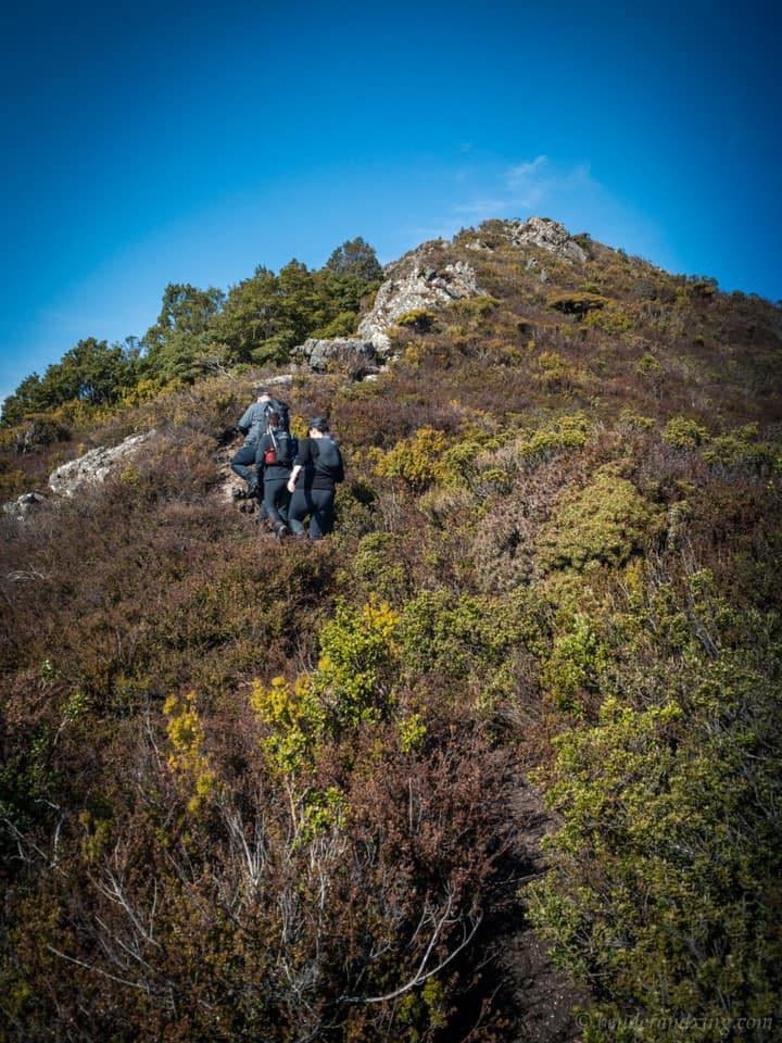
After winding our way up through the lush green canopy the underfoot terrain abruptly changed. The path widened and at the same time the skyline became visible above us through the trees. Then, the forest canopy quickly gave way to waist-high alpine scrub and a relatively exposed rocky pinch onto the beginning of St. Valentines' characteristic knife-like ridge. Haydyn, Natty and I had previously climbed this section in our last attempt, however, we had mist hiding the steep drop off from us. Not this time! It took only a few minutes to scramble to where we, once again, were standing with a protective layer of dense alpine scrub to either side of the track. We were now officially on the ridge that leads to the summit. We could also take in the views below us for the first time.

Weaving along the initial part of St. Valentines' ridge.

Weaving along the initial part of St. Valentines' ridge.
The first small section of the long ridge line is easily negotiated. There were a few moments on and off where both Haydyn and I were proceeding more cautiously than the others, but overall we were enjoying this section. The track is still easy to follow at this stage, but a small way along this first part of the ridge the track splits into two. It took a few moments to spot pink ruben tape indicating we continue to go straight ahead and not climb upwards towards a rocky hill. Ben would later return and climb the rocks for a photo opportunity.

Looking back down the ridgeline towards the knob Ben would later climb for a photo.

Traversing the ridge.
We circumnavigated around the rocky hill following the pink ruben tape and it landed us behind the hill with a clear view of the track leading towards the summit proper. It would involve following the knife-like ridge up and down two more small knolls before reaching the trig point. We continued on the rocky paths, occasionally broken up with climbing over or around larger rocks that block the trail. There is some small amount of exposure at times and given it is totally not Haydyn's thing, he was nailing it. After circumnavigating the first rocky hill the rueben tape stopped but it was no longer necessary to assist with navigation as the track leading all the way from here to the summit was obvious.

The memorial sitting high on St. Valentines Peak. R.I.P.
After cresting the initial section of ridge, we could see below us what appeared to be a pole marker. Reaching it after following the track down we were surprised to see that it was not a pole marker at all, but a memorial. I got a bit emotional wondering who this might be and why he/she was here. Our research had indicated that the mountain was named after Henry Hellyer who first ascended it in 1827. This memorial was more recent than that. We stopped for a few moments to respect the enormity of what was here and to agree among us that we would make an effort to learn about this person when we got home. It turned out that the summit would reveal at least part of the story to those of us that climb St. Valentines Peak.

The summit trig within our sights.

Closing in on the trig.
A small push along the last of the ridgeline bought the summit into sight. We had decided we would lunch like kings on the top of the helipad, but headed past the tiny communications shed straight for the trig to bag the mountain first. By this stage the sun was shinning brightly, barely a cloud in the sky and we enjoyed 360 degree views. You can't ask for better than that!

The old radio communications shed and trig point.

Haydyn enjoying the views.
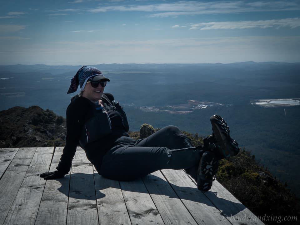
Natty kicking back in style!
After dining in style in the sun on top of the mountain - a welcome change after a few months of less-hospitable winter summits - it was time to start the trek home. It had taken us a bit over two hours to the summit from the car with lots of photos stops. We knew the return trip home would be much quicker if for no other reason than it was downhill! Ben and Natty were looking forward to getting back down the rocky knob we had passed on the way in as Ben wanted to climb it for a photo opportunity. Haydyn and I would be happy just to be off the ridge safely!

Soaking in the views before or climb back down.

Enjoying the descent.
The return journey was proving quicker as expected but some areas required a little more concentration than on the way up. It is always easier going up an exposed area than down it! Nothing that is insurmountable with a good grip and careful foot and hand placement. I even admit that I was actually enjoying the exposure on the way down due to the views afforded to us by it. Even Haydyn was happily snapping photos.
On descending the final section of ridgeline the entry point to the drop back into the forest canopy is very well hidden. We were lucky the day was bright and clear, we certainly wouldn't want to be scrambling around in cloud cover or mist trying to find the very steep and narrow entry point.

About to drop back into the forest.
The descent through the canopy was quick and it highlighted how deceptively steep the climb was on the way up. We knew the elevation had increased whilst going up obviously but until we were coming down we didn't realise by quite how much. As the descent levelled out, we again hit the unmaintained boggy marsh just after leaving the fire trail. We made rapid time back to the Old Park River and the return journey back across the log was much easier, perhaps as we immediately held the rope taught! A small sting in the tail by way of a sharp climb back up to the car park and it was time for some fresh clean clothes, a snack and reminiscing about bagging another Abel; number 41 for both Ben and I, number 20 for Natty and number 15 for Haydyn.
The stats.
Distance: 9.6km
Time taken: Under 5 hrs total including breaks and lots of photos.
Difficulty: Save for a couple of thinner sections of the ridge line where due care and attention is required, it's a pretty easy track.
Type of track: Formed single track with some sections of boardwalk, formed steps and a couple of bridges.
Access from: Carpark off Kara Road.
