Wentworth Hills
Date: 6th June 2020 – Summit: 1244m

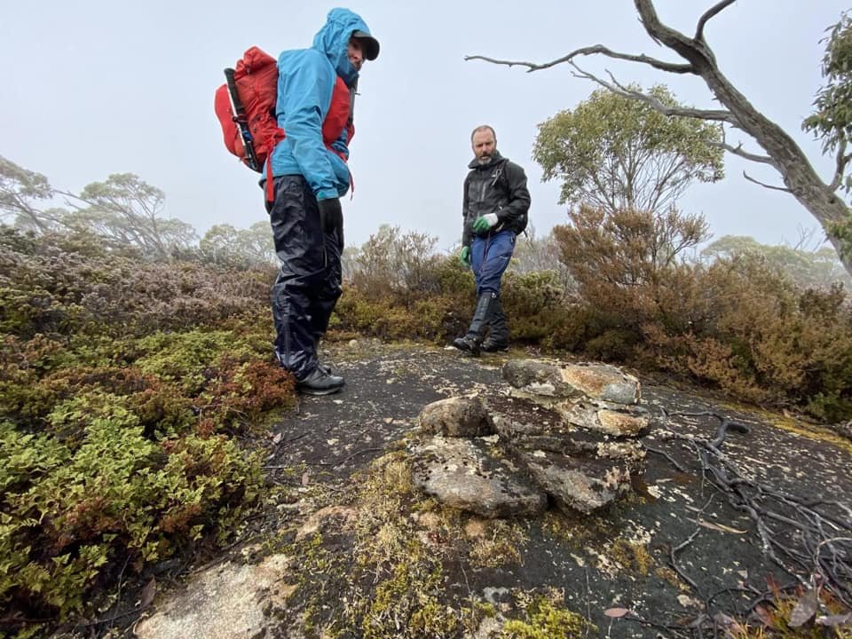
Wentworth Hills summit in the grey mist ahead.
The Abels mentions that Wentworth Hills is "rarely-visited" and often "overlooked". We can see why. Perhaps we are being a little ungracious because for all the work required to get to the summit, we got not a single view. Not even a whisper. What was planned as a 3km "bush-bash" to the summit turned into a long 18km day of tripping, falling and climbing, all whilst being wet and cold. Oh the joys of winter hiking in Tasmania. If you think this introduction is ungracious then don't ask our thoughts on Forestry Tasmania Sustainable Timber Tasmania and road access...
Why not watch & read?
Please enjoy a visual trip to Wentworth Hills in addition to the blog below. Whilst the blog gives you greater detail on the trip (including route information) the video allows those that may never reach its summit a virtual experience.
We should preface this essay by mentioning that our day out to Wentworth Hills was not as we had originally planned. Some months earlier (pre-COVID-19 lockdown) Ben and I had climbed Mt. King William I and then spent a few hours on our mountain bikes exploring forestry access roads that would bring us close to the Wentworth Hills summit. Only after riding the forestry roads and getting thoroughly wet and muddy did we discover that that the same roads we had ridden could actually be driven! We were excited to locate a forestry road and currently used coup that bought us to within 1.5km of the summit. Yes, it would be a straight up, steep and dense bush bash but it would be short lived pain for big return. We planned on returning the following weekend to climb it. Then COVID-19 hit and Tasmania effectively shut down all access to national parks and reserves. Doesn't matter we thought - it will still be there when we return. Not quite...

The boom gate blocking access to the forestry road we had planned on driving.

Heading bush from the boom gate.
Setting off from Launceston around 5:30am had us driving into Laughing Jack Lagoon a bit before 8:30am. A friend of ours Chris was coming along and we had worded him up about the exciting short and nasty route we had found from the logging coup road to the summit. And then - with the sight of a locked boom gate our hopes and dreams died. How. Could. They? They being Sustainable Timber Tasmania. The boom gate blocked access to all the roads past Laughing Jack Lagoon. Turns out the forestry coup we had found back in March had been the recipient of a protest the week after we found it and as such the boom gate had been shut to stop access. Disappointed but not deterred we swallowed a bitter pill and resigned ourselves to going up the "regular" way. Ben had graciously been given a GPX file from Lucas Chamberlain (check him out on YouTube) and we would use that in conjunction with some maps Chris had prepared. Leaving the cars parked at the boom gate, we entered the scrub.

Small logging tracks make for easier going in places.

Forest litter.
It immediately became apparent we were in for an up-and-over, duck-and-weave kinda day. Whilst this initial section of scrub wasn't dense and could not be described as "bush-bashing" in any way it was mildly inconvenient picking our way over fallen logs or around eucalypt trees. A clearing nearby made for quicker walking than being in the scrub, but it was particularly slippery and muddy given the recent rains and light frosting of ice covering the forestry litter.

Using small sections of road to break the walk.

Looking along the felled area.

Picking a route through the coup.
The clearing gave way to a short-lived section of road before once again entering another larger cleared area. Its probably the first time I have ever actually walked through a clear-felled area and I was surprised by how much mess of timber is left behind. The scraps left behind were in various stages of breakdown, sometimes crumbling under our feet, sometimes the ice covering them reminded us that if there was ice this low it would be more than a little chilly up top! Beneath the timber scattered across the ground was thick clay soil.

Time to get amongst the bush and out of the coup.

Constant fallen timber to negotiate.
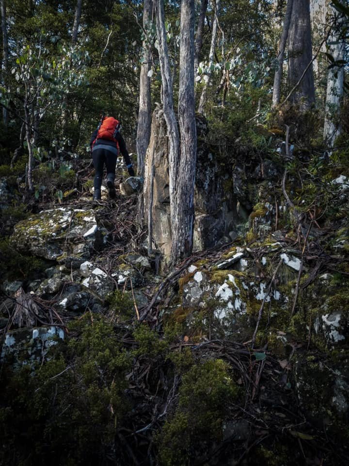
With the last of the clearings left behind, it was time to enter the vegetation. Certainly the scrub on our ascent from the north was annoying - but would we call it dense? No. Irritating yes, difficult no. Whilst is was easy enough to duck and weave most of the patches of scrub, the constant clamouring over fallen logs covered in slimy, slippery moss began to wear thin early on. We could barely trust our footing, given how slippery the timber strewn forest floor was.

Large, slippery fallen logs to climb made for slower going.

When the forest floor wasn't littered with timber it was littered with rocks.
Short lived pinchy climbs increased the elevation gradually.
Our progress was slower than we had hoped because of the slip factor. Up, over, around, up, over. Repeat. It wasn't a particularly steep climb at this early stage but there was very definite increase in elevation.
Chris was leading, I was middle scout and Ben was bringing up the rear, photographing as usual. I was enjoying not leading for a change, and just letting someone else navigate. Chris is an exceptionally capable hiker and I would be happy to be blindfolded and follow him, such is my trust in his abilities. He would occasionally check in with Ben to see if we were within the scope of the GPX file. Amusingly Chris and I realised half way into the hike that each time he asked Ben "are we good?", meaning on track with the GPX, Ben actually thought we were asking if he was good as he was trailing behind for filming purposes.

Picking our way up through the vegetation
Elevation increasing.

Occasional rocky outcrops needed negotiating.
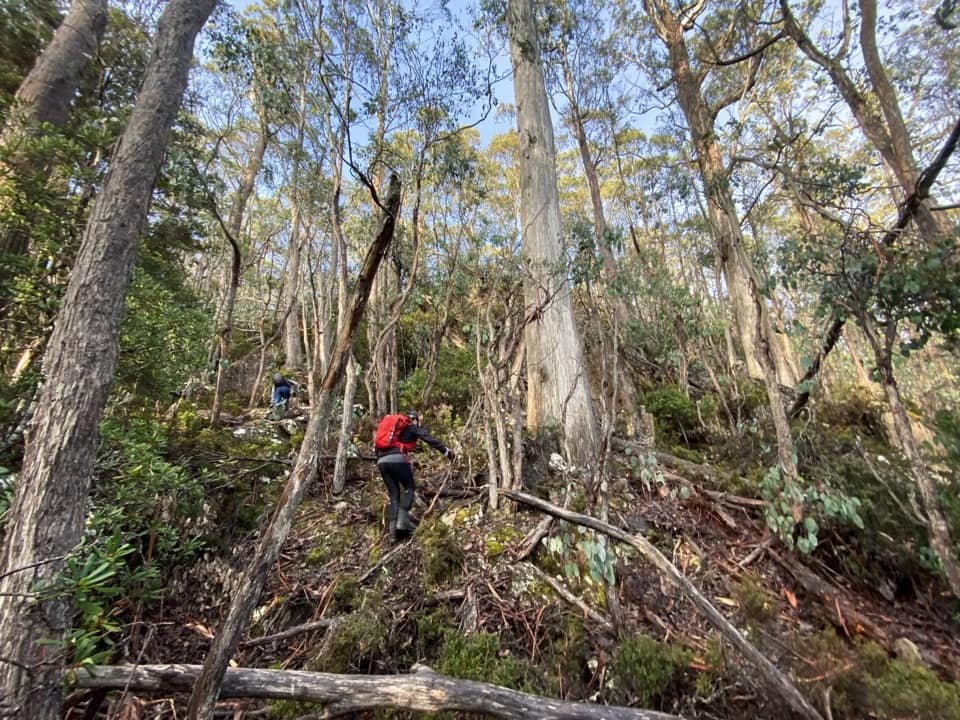
We continued our climb towards D'Arcys Bluff and the gradual climb was broken occasionally with shorty pinchy sections that required more effort. Our revised plan was to climb up the ridgeline to the north-east of D'Arcys Bluff, head across to Lake Knight and then summit Wentworth Hills from there.

Sometime large boulders needed skirting.

The beautiful tall eucalypts.

Continuing towards the top of the unnamed hill east of D'Arcy's Bluff.
Earlier that morning when leaving the car the temperature gauge had read 3 degrees celcius and it felt cooler still as we climbed higher. Surrounded by the forest canopy we were quite sheltered from the winds we could hear above us, but there was an unquestionable feeling that it was snowing somewhere close. A bit of white stuff on the summit seemed entirely possible.

Still no views of anything but forest!

Chris and I discussing options around locating easier vegetation to walk.

Descending down towards what would be easier walking.
Each step towards our goal involved assessing the terrain immediately before us. Up, over, under, around. Nothing problematic but somewhat arduous due to the slip factor of the sodden and/or ice covered ground. Brief dense patches of scrub had us all commenting how many snakes would be hiding underfoot in summer and deciding maybe winter wasn't too bad a time of year to climb Wentworth Hills! Reaching the top of the small, unnamed hill on the east of D'Arcy's bluff we were disappointed to have no other view than yet more scrub hiding our destination. With all of us over the annoyance of the scrub we elected to drop down to a "marshy" area shown on Avenza Maps. Marshy areas would not be our normal choice of walking terrain in winter but we figured it would give us some respite from the bush.

Route checking.
Lovely coral fern, scoparia and low laying vegetation to wander through.

Reentering the scrub that would lead us up towards Lake Knight.
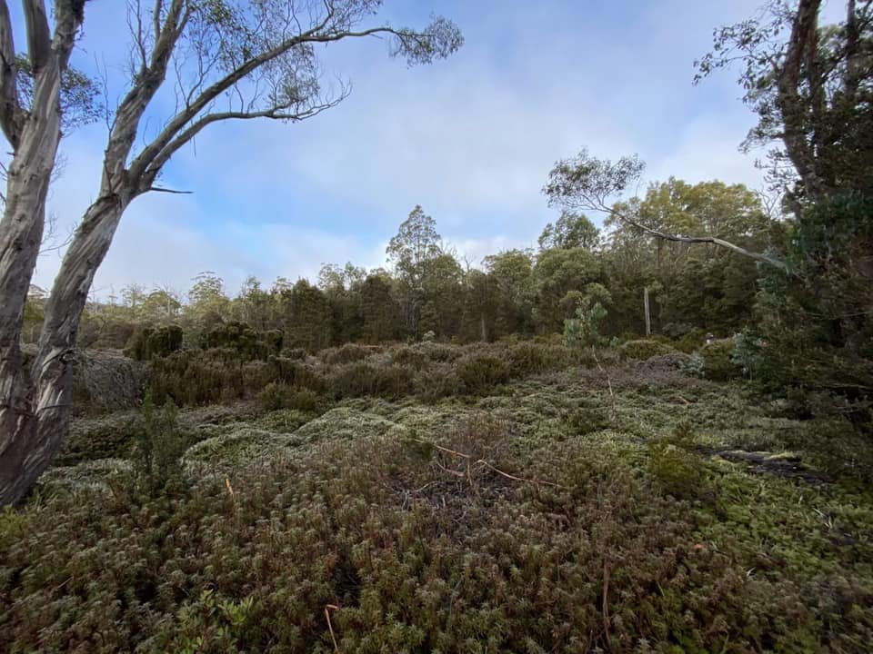
Our longed-for marshy area turned out to be low laying shrubbery, pineapple grass and short scoparia. Better that soggy timber and rocks underfoot though! It was fleeting however, and we entered the last band of scrub between us and Lake Knight.

At times weaving between the trees, but getting a descent foot hold on mossy rocks was a fine balancing act.

The final small boulder climb before the open expanse prior to Lake Knight.

Using less dense pockets of vegetation to our advantage.

The last band of scrub to go through before Lake Knight.
The coral fern plateau at the base of Wenworth Hills. Lake Knight completely hidden in mist.
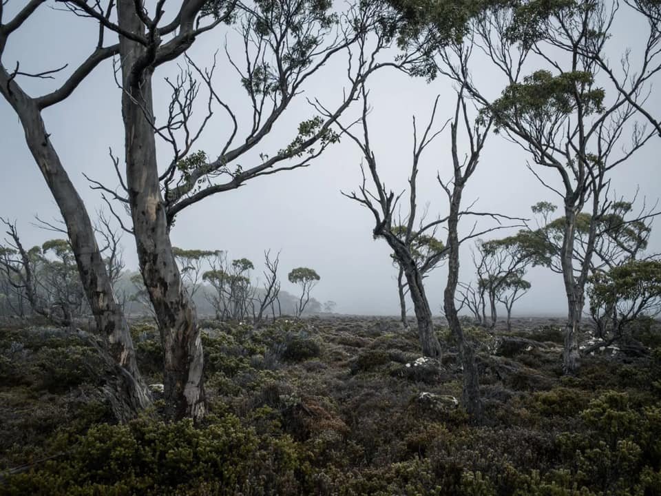
The final band of vegetation between us and the open expanse surrounding Lake Knight was a section of eucalpt, myrtle beech and moss covered rocks. Stepping out onto the open expanse I would love to say we were treated with our first spectacular glimpse of Lake Knight, but alas, no. Mist shrouded everything and faint snow was starting to fall. We allowed ourselves few moments to pop on our wet weathers, eat some food and have a few sips of coffee to warm up before pushing on. With the temperature now freezing standing still wasn't an option!

Frozen tarns on the way towards Lake Knight.

D'Arcy's Bluff hidden behind mist.

Scoparia looking delightful frosted in snow.

Pencil Pines on the shores of Lake Knight.
Whilst we were now exposed to the bitingly cold winds and snow it was lovely to not have to take so much care with our footing. The coral fern fields surrounding the north eastern side of Lake Knight were frosted with ice and boggy underfoot, but not difficult to traverse given the plethora of animal pads to weave along.

Chris learning that the Galaxias are fish not birds!

After crossing Lake Knight and no sight of Wentworth Hills in the background.

Our crossing point for the lake.

Normally the trig would be visible from the shores of Lake Knight, but not today.
Standing on the shore of Lake Knight we would have been able to spy the trig point on the summit if the entire mountain wasn't covered in mist! I tried to spot the Clarence Galaxias that the lake is one of the few remaining trout-free refuges for, but even they were hiding from the cold today. Crossing the lake was easy enough, and then it was time to wander yet more coral fern to reach the base of Wentworth Hills. The coral fern on the south-eastern side of the lake was thicker, higher and tiring on my little legs. It was almost a full 'lunge step' onto some of the mounds - I was actually looking forward to the scrub again. Be careful what you wish for!

Leaving the coral fern behind to enter the bush again.

Low-lying vegetation but enough rocks and logs to be annoying.

Picking the path of least resistance up.

Brief bands of denser scrub.
Leaving the coral fern behind and entering the scrub involved initially picking our way as best we could through prickly scoparia. That gave way to the densest bush that we had faced yet. This section is the first time I would have classified us as "bush-bashing" for the day. Not on a Mt. Tor or Marriots Lookout kinda way - but effort was required. We were gradually climbing again after the level plains around the lake below us.

The first glimpse of the summit outcrop through the mist.
A cairn in the middle of nowhere with no other cairn friends....

The trig!

Trying to stay upright in the wind whilst clambering over icy, mossy rocks.

Little stalactites of ice, reminding us just how cold it was.
It was with some relief that we glimpsed the trig point in the distance, and even more of a relief when the scrub bands gave way to lower alpine vegetation and rocky understory. The elevation again levelled off and although the terrain was easy, the wind was howling and ice actually hung off the trees like stalactites. It was time to tackle the rock talus below the summit and then get off the mountain!

The black moss covered boulders below the summit.

Using the vegetation for grip rather than a direct ascent on the rocks.

The views make it all worth it....
he rock scramble to the summit wasn't hard but the rock was extremely slippery given its covering of damp black moss and frost and we all had a few "ice-skating" moments on the way up. A bit over 7km from the car and it had taken us longer than expected in the conditions - approx. 4 hours and 45 minutes. A hurried food stop at the summit bought us to around 5 hours. Even though the going would no doubt be faster on the descent it was still more probable than not that we would be making at least part of the descent by head torch. Slippery rock and timber, thick forest and no track isn't that much fun after dark.
The weather had deteriorated considerably. It was now properly snowing, decidedly freezing and none of us relished being out longer than necessary. After discussing our route options we agreed that we would descend south-westerly to the forestry road below that we had originally planned walking up. Although it would mean an extra few kilometres on foot, the extra distance would be on road and easily managed with head torches if need be. Importantly, it would get us down to a safer elevation quickly, should the weather continue to deteriorate.
Chris had tentatively marked out a route that would avoid the worst of the boulders and small cliffs. On a dry summer's day with full visibility, the huge boulders wouldn't pose a problem but we had near zero visibility below and none of us wanted to drop off something that was higher than anticipated and regret it! We would use a green band to our east to drop our elevation until we hit the scrub again and could change back to our south-westerly course.

Heading directly east off the summit for the green band that would avoid boulder scrambling in near zero visibility.

Descending through a lovely open patch of Pandani.

The steep boulder/cliff area directly west of the summit area, confirming we had made the right decision in the weather to avoid them.

A brief glimpse of Lake King William in the distance before we are enveloped by the scrub.
The initial rocky descent from the summit did involve a little bum-sliding! Icy rocks don't make for great rock hopping partners and today it was about getting off the mountain safely. Descending from the summit we went wide, heading south-easterly as we picked through the green band and descended. Looking up towards the summit we were glad we hadn't tried a direct descent! Chris had a compass bearing prepped for the moment we hit the bush and had no line of sight of the road, Ben had his InReach and I was using Avenza Maps and my InReach. I am normally a map and compass girl but am trying to extend my skills to using "electronic" mapping tools. Soon the bush would swallow us up. Whilst we were all cold, tired, wet and weary, I was also excited as our descent would mirror the ascent that we had initially planned. We would get to see the alternate route - with the added benefit of gravity.

Now the fun begins.

Descending towards the Lake and forestry road.

Delightful Pandani but a mess of forest to pick through.

Yet more fallen wet timber.

Oh wait - more fallen wet timber to climb over.
There is no denying we had hit scrub bashing time! In places we needed to use our full body weight to push through head high scrub. In other places we would have made ninja warriors proud with our expert ducking and weaving skills. Up over logs, down over logs. Slip, slide, trip, fall.
I was having a great time but I was struggling with my right foot - my big toe and the toe next to it to be specific. I hadn't mentioned it to the boys, but my toes had started to display signs of frostnip before the summit and then superficial frostbite at the summit. I've previously suffered frostnip so know the onset well. Initially cold and prickly my toes had then started to warm and tingle. I had hoped when we started moving again it would dissipate, but alas no. An hour after leaving the summit the numbness around my big toe was making it hard to feel the ground and the burning was excruciating. I had to fess up - better that than lose a toe or two!
We stopped to take my boot off and look at my now bright red toes that when pressed on went pale white with very slow to no blood return. Touching them was excruciating and heating them too quick would have been a disaster. A few minutes of Ben's warmed hands bringing them gradually back up in temperature, some fresh dry socks and loosening of my boot (to allow increased space and airflow which allows the air to warm and circulate around the toes) had me stepping off again. Fluid blisters appeared around the two toes by the next evening so stopping was most definitely the right thing to do and prevented what was superficial frost bite becoming more severe and damaging.

The forest opening up as we near the forestry coup.

The final mess of timber and clay to pick through.

Oh look the car is parked there. Hang on - no it's not. Thanks Forestry!

The trudge home before we lose the light.
With two functioning feet it was time to continue the scrub bash downwards. The final 500m of the descent involved wandering down through more open forest with lovely moss covering the ground. It reminded me a little of the initial climb through the forests of Mt. Ida.
Stepping out into the logging coup - that should have housed our car - we began the tedious journey of 7km of forest road back towards Laughing Jack Lagoon. My watch battery died at this stage and for a while we debated whether I would rather have a full recording of the route on my watch or my two frost bitten toes. Only a true Abel bagger would chose the watch over the toes but alas I kept my toes and lost the watch recording :-P
About an hour and half later we finally reached the car, just as darkness was descending.
The stats.
Distance: Approx. 18km return. Note we completed a loop rather than an out-and-back hike.
Time taken: 8.5 Hours including short breaks.
Difficulty: Hard. Much of the hike is through forest with sometimes dense scrub. Good navigational skills are required and walkers should only proceed if experienced and properly equipped for extremes of weather.
Type of track: Trackless. Terrain varies and includes everything from eucalypt and myrtle forests, dense alpine scrub, rocky outcrops and constant fallen mossy logs.
Access from: Fourteen Mile Road and Laughing Jack Lagoon.

Route taken to Wentworth Hills.