Western Arthurs Day 6
Day 6
23rd January 2021
Haven Lake to Wullyawa Creek
Additional climbs – Mt. Aldebaran and Mt. Scorpio

The slanted face of Mt. Scorpio. Photo Credit: With thanks to Grahame Kershaw.
Waking on Day 6 of our Western Arthurs adventure bought with it the promise of nicer weather. We planned on being on track early, as we all wanted to climb Mt. Aldebaran and Mt. Scorpio - our final Abels of the trip - before making camp at Wullyawa Creek. Even with a short cut off Morraine K, today promised to be a big walk. Our long day was intensely rewarding though. Standing on Mt. Scorpio before dropping off the range allowed us to see the ridgeline in all its glory. We had come an awful long way, over a lot of pointy things!
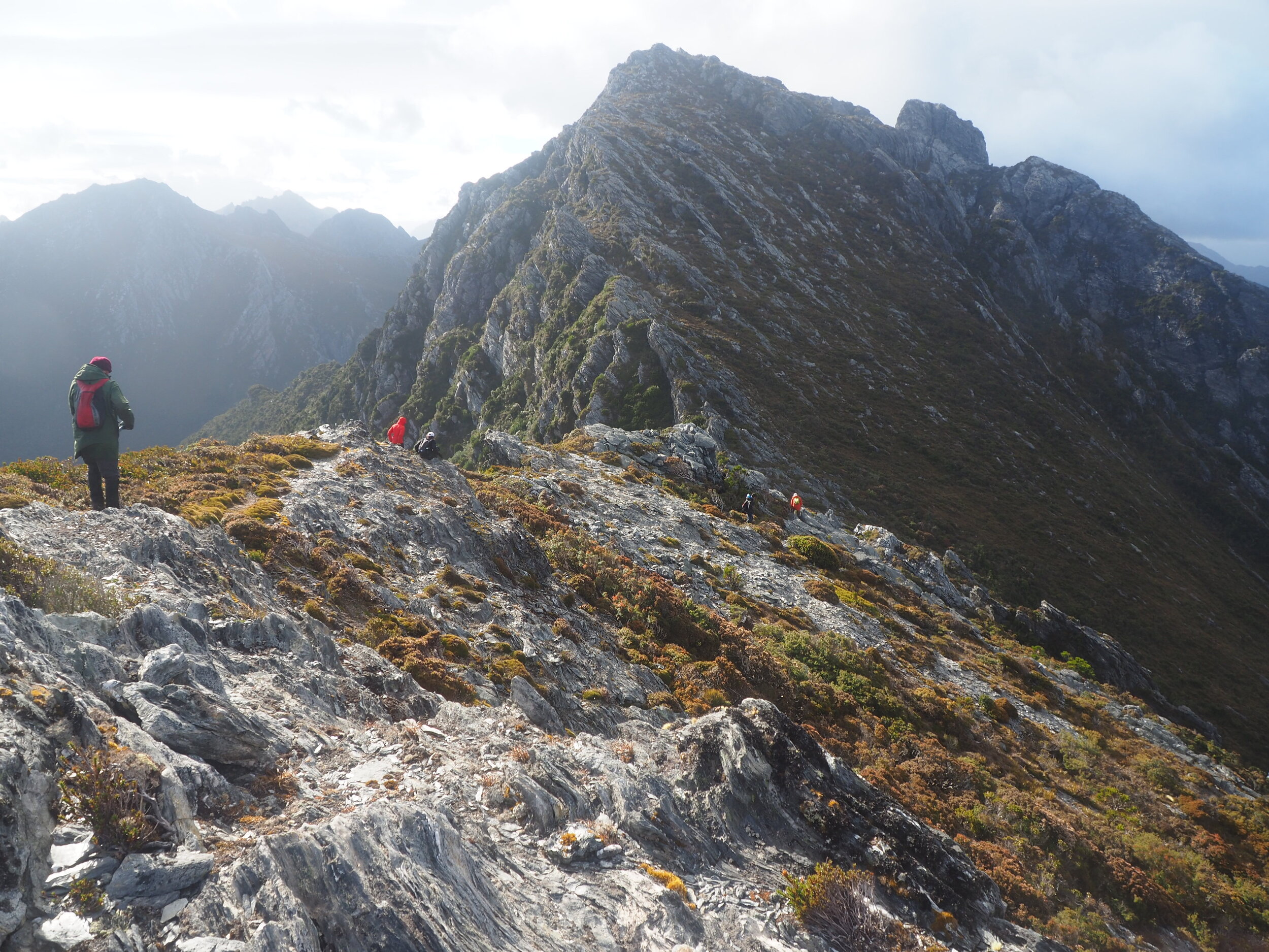
Mt Aldebaran bound. Photo Credit: With thanks to Simon Kendrick.
Why not watch & read?
Please enjoy a visual trip to The Western Arthurs in addition to the blog below. Whilst the blog gives you greater detail on the trip (including route information) the video allows those that may never reach its summit a virtual experience.
Having not slept again the night before for fear of the tent flying away quicker than Aladdin's Carpet, I was up early and packed well before the 8am kick off time. I started the climb out of Haven Lake early so I could get some shots of the others down below. We would be leaving our big packs at the small saddle at the top of the climb out. Chapman's book claims it is about two hours each way for Mt Aldebaran - fortunately it took us considerably less than that.
Mt. Aldebaran

Photo Credit: With thanks Simon Kendrick.
Gladly dropping our big packs we changed over to summit packs and surveyed the possible route forward. The rough plan was from the saddle above Haven Lake, we would head southeast towards a 950m high point, over the top of that, and drop into the next saddle. Climb from there up to the next 1050m high point, drop briefly, and then climb to the summit of Mt. Aldebaran. We certainly were not expecting a cairned route with a (mostly) well trodden pad! It was a delightful surprise.
A pad left from the saddle where we dropped our packs towards a rocky slab in the low vegetation. A scout around indicated that the slab needed climbing and we would pick the trail up again at the top. Whilst it looked tricky it was a simple enough matter to climb it. Back on the pad, we followed it to the 950m high point. This new vantage point gave us uninterrupted views ahead of the sloping bulk of Mt. Aldebaran. The summit was not yet visible, as it lay beyond to the south east.
Navigation had been easy thus far. Where we might momentarily lose the pad, we would pick it up quite quickly due to the odd cairn popping its head out in the near-distance. The route roughly followed the rocky spine of Mt Aldebaran, but at times we would need to skirt small amounts of vegetation. As we climbed higher the views to our east and Mt .Scorpio began to reveal themselves. That was our target for later in the day, and looked some distance away!
The summit is nearly always the furthest high point away and Mt. Aldebaran was no exception. It was as if it was teasing us by appearing further away the closer we got! We were genuinely surprised and pleased with the ease of the climb though and it was in just under 30 minutes that our fingers touched the summit cairn. WOW - the views were breathtaking!
There were eye-to-eye grins all around, as we sat in the sun eating our morning tea at the finest restaurant in the world. Making great time to the summit meant we also got to spend that extra time there just immersing ourselves in the views on offer in every direction. Alas, all good things come to an end - Mt. Scorpio looked a long way away. It was time to retrace our steps back to our packs and continue our traverse of the range.

Photo Credit: With thanks to Grahame Kershaw.
To Scorpio and beyond.
My big pack felt heavy as I strapped it on once again, and already I could feel the sun heating up the rock and scrub. I was hoping the slight breeze blowing would pick up, and offer some respite from what was going to be a very warm day. Moments after lifting our big packs on we were again on track heading north. An ancient Pencil Pine weathered on one side and vibrant on the other was a visual representation of the extremes of weather that the Western Arthurs offers those that travel through them.
The walking from this point forwards actually resembled bushwalking, for what seemed like the first time since Lake Cygnus! Whilst still undulating the terrain was open now and we could stride our legs out. How lovely it felt! According to my map we would have a substantial drop in elevation before Mt. Scorpio, but for now I was loving - and I mean loving - the walking!

Photo Credit: With thanks to Jess McDonald.
With Mt. Scorpio rising in the distance to our northeast, and the tantalisingly cold and refreshing Lake Sirona below our feet, we began climbing downwards again. I was happily tackling this slightly more technical descent, as I figured anything was better than Tilted Chasm - and I was eager to refill my water bottles! Grahame and I were the first to arrive at what initially appeared to be a large and impassable rock ledge. Cairns led directly off the edge of it in both directions! One direction was a flat-out no, and the other direction wasn't much better!
After much deliberation Grahame and I managed to scale down one side of the rock cliff, but it was awkward and more than a little dodgy! John followed using a slightly different path but Chris, Jess and Simon - along with our young friends, who'd caught up by this stage - opted to use a lead through the scrub and contour around the slab, which was probably, ok definitely, the more sensible option.
Number 100 for Chris.
Greedily slurping our fill of ice-cold water at the lake we were now within cooee of Mt Scorpio - its famous slanted summit rock calling to us. The degree of the slope was a little intimidating, but Simon had mentioned earlier that there was a route to the summit from the rear instead. Yes, please!
Simon was right of course. Although the pad seemed to be leading up to the slanted rock face of Mt. Scorpio, it actually ducked behind it. After following the pad for a few minutes until we were almost level with the summit high point, we decided to drop our packs and summit before lunch. It would take literally only minutes to get to the summit via a series of pads and nice sized rock to scramble.
Celebration time.
Not only were we now all standing on Mt. Scorpio, but it was Chris's 100th Abel - congratulations mate, and what a peak to mark 100! It was a mighty fine day to be up high, that's for sure!
As I sat on Mt. Scorpio I reflected on the challenges and triumphs of the last six days. Our journey was beginning to turn the corner from outward adventure to homeward voyage. I had mixed feelings. I was exhausted physically and mentally, but I was enriched from being immersed in the Arthurs. We still had many, many hours ahead of us before we would reach camp for the night. But for the next few moments, it was all about the company and the mountains.
The long drop.
Morraine K was waiting. It would be the very last steep descent that we would do and it would lead us down and off the Western Arthur range. A short section of it promised to be very steep indeed, as we would drop around 200m of elevation over less than 300m of distance! Poles at the ready we descended steadily to the lower echelons of Morraine K. Burnt remnants of the 2019 fires reminded us of just how fragile this place really is. Even now, some tracks remain closed allowing for rehabilitation to take place.
Life renewing.
Bright and vibrant flowers rising up from the charred ground were a wonderful thing to see. The evidence that one day - a long time from now - this delicate place might one day return to its former splendour was reassuring. Maybe not in my lifetime, but perhaps in that of my children or grandchildren.
Instead of continuing down the full length of Moraine K until the usual Seven Mile Creek campsite, our group had decided to take an informal, off-track route north-west to rejoin McKays Track before Wullyawa Creek. It would cut out a few unnecessary kilometres and shorten up our walk out the next day. We feared that Seven Mile Creek camp could be as overwhelmed as Haven Lake had been the night before. John had a GPS route of the shortcut that would allow us to navigate back onto the track at some stage.
The long, long, long and hot, hot, hot road to camp!
The "shortcut" we were taking meant that we would be off-track for at least part of the way to camp. Occasional patches of scrub made the hot work hotter, as did what seemed like endless amounts of button grass. The grass held the afternoon heat and I felt like I was walking through a blistering desert. We didn't have the lovely cool alpine air of the higher mountains we'd grown accustomed to the past week, and I began to really suffer from the heat. My mouth was dry no matter how much water I drank, and I was starting to feel quite dizzy. As the others crested a small hill I dropped my pack and applied a couple of cooling gel patches to my neck and chest. The relief was instant and pure bliss!
Eventually, the McKays track finally appeared under our feet and the walking became easier. Whilst still an incredibly hot trudge in the hot afternoon sun, we now had a pad to follow and were no longer walking through the button grass clumps. My knees rejoiced! It was a matter of just keeping the rhythm of step by step to the creek.
Heaven and a feast.
Reaching Wullyawa Creek was a relief. It was shady, cool, and tranquil. The water was crisp, clear, and refreshing. The campsites were small but everyone had room and after two very breezy nights, we wouldn't have to worry about being blown away.
A junior Huon pine tree hid in amongst the other trees and soft green mosses lined everything. Tonight we would feast too! As it was our last night on trail, we were all eager to eat as much as possible to save carrying it out the next day. Dinner with multiple deserts and chocolate all around. The conversation of what we would eat tomorrow at the Possum Shed Cafe consumed us. It seems the consensus was on how good hot chips would taste! But soon enough it was time for the best night's sleep yet. Ah, the serenity.
The stats.
Distance: Approximately 11.7km, including side trips to Mt. Aldebaran and Mt. Scorpio.
Time taken: Just under 9 hours. Although the distance covered was short, the rugged terrain and endlessly sharp climbs (up and down) made for very slow going, as did the heat intensifying in the latter parts of the day in the Arthur Plains.
Difficulty: Difficult. This walk should only be undertaken by experienced hikers confident in negotiating varying degrees of exposure/heights, rough terrain and are in good physical shape to cope with such ground carrying a heavy pack. While the pad in this area is mostly obvious, it is unmarked, and thus strong navigational skills are also a must.
Type of track: Haven Lake to Morraine K is tracked. Some light pads and cairns lead towards the side trips of Mt. Scorpio and Mt Aldebaran. The shortcut from Morraine K across the Arthur Plains to near Wullyawa Creek was untracked so strong navigational skills are needed until you reach McKays Track again.

Route taken from Haven Lake to Wullyawa Creek.