Western Arthurs Day 7
Day 7
24th January 2021
Wullyawa Creek to Huon River Camp/Scotts Peak Dam
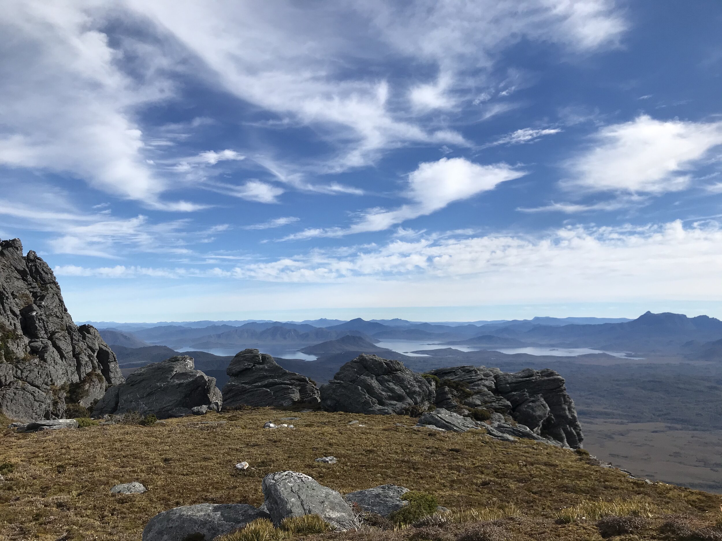
Photo Credit: With thanks Jess McDonald.
The end was nigh - our Western Arthurs adventure was drawing to a close. All that stood between us and hot chips at the Possum Café was 15 kilometres of lumpy, rutted track leading through endless button grass plains. The "death march" home, as I like to call it, would have none of the glorious elevated vistas we had enjoyed for the previous six days. Long and very hot would be how I would describe our last day. Still, you have to go home at some point!

Looking back at the range. Photo Credit: With thanks Jess McDonald.
Why not watch & read?
Please enjoy a visual trip to The Western Arthurs in addition to the blog below. Whilst the blog gives you greater detail on the trip (including route information) the video allows those that may never reach its summit a virtual experience.
Finding out that west of Moraine K was closed stopped us heading out to Promontory Lake for a night to attempt West Portal. Thus it meant that our trip would finish a day earlier than expected. Reaching Wullyawa Creek the afternoon before ensured today's trip out was more manageable. Although our packs were lighter and the trails flatter, the rapidly rising temperature of the morning promised to make our wanderings anything but easy! Leaving the shade behind us, we entered the button grass plains that line the Arthur Plains Track. The Arthur Plains Track would lead us north west to the Port Davey/McKays Track Junction.
The narrow path allowed for easy walking through the low vegetation. For the most part the track was reasonably well kept by the many pairs of boots that now travel along this route each year. Old metal stakes acted as track markers, likely useful in winter where it wouldn't take much snow to completely hide the pad. The Western Arthur range was now shrouded in low cloud and the weather up there didn't look very appealing. Evidentially we'd timed our trip well!
More of the same-same.
Endless expanses of low vegetation and button grass were very occasionally broken up with short bands of trees and scrub that we would hide in for a moment, trying to soak up some cool shade. The mood was a tad quiet, heads down, walking in single file, looking every bit the band of weary walkers that we were. Every so often, we would turn and to see if the mist had lifted off the range.
We had set off early to beat at least some of the morning heat, and we were pushing a consistent pace, as we all wanted to make it to the cars and then the Possum Café in Westerway in time for a post track feed! I was focused on reaching the Port Davey/McKays Track Junction, as from there it would be under 10kms until we were back at the car!
Disappearing stairs.
Reaching the old timber signs at the junction, we allowed ourselves a few moments to look back at the range and be appreciative of what we had all individually and collectively achieved over the last week. After a few photos, we decided to head down to the shade of Junction Creek for a bit of morning tea.
Less than a week earlier, when I had come through this very spot, it was completely flooded. It was a little weird sitting down to eat in what had been knee-deep water previously. Even weirder to see stairs and the actual crossing! The whole lot had been underwater.
With morning tea over, it was time to cross the creek and start the final trudge to the cars. Along the way we met several groups of walkers heading into the range. Them fresh-legged and fresh-smelling, us exhausted and probably quite smelly! As we passed them our group would silently smile; "let's see them in a week" we would think, and our grins would widen. Hopefully they too would walk out later with a quiet smile like ours, and the sense of achievement and gratitude that only the Western Arthurs can give you.

Photo Credit: With tanks to Simon Kendrick.
The stats.
Distance: Approximately 15km, from camp at Wullyawa Creek to the carpark at Huon Camp/Scotts Peak Dam.
Time taken: About 5 hours. Whilst the walking is mostly flat, the tracks have suffered some degradation in places, so progress in was a bit slower.
Difficulty: Other than the distance to be covered and the relative exposure to adverse weather throughout much of it, this section is fairly easy walking. Due to the lack of drainage and increasing visitor traffic, some sections are deeply rutted with numerous deep mud bogs to pass through. As we had discovered on our trip in, the many creek crossings including Junction Creek will flood during and after heavy rain, and in some cases may require waiting out a day for levels to drop to a safe level.
Type of track: Both the Arthur Plains and McKays Tracks are obvious pads with regular markers and some hardening/improvement in areas.
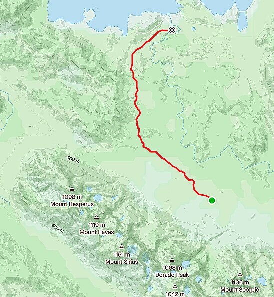
Route taken from Wullyawa Creek to Huon River Camp/Scotts Peak Dam.