Cradle Mountain
Date: 8th August 2020 Summit: 1545m

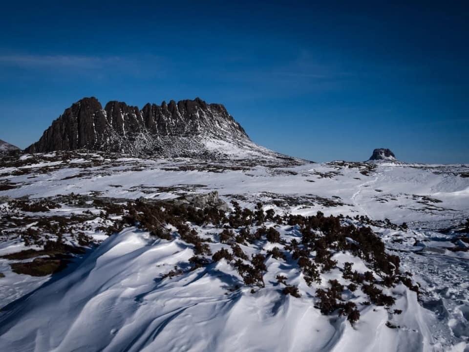
Views below from half way up Cradle Mountain.
A fresh dump of snow and a new hut to check out were the perfect excuses to re-visit this iconic mountain. It's the postcard picture of Cradle Mountain rising behind the southern end of Dove Lake that draws thousands of tourists and hikers alike to this pristine part of Tasmania. I’ve previously climbed her summit in the summer of 2019 along with my friend Mel as part of a full traverse of the Overland Track. Since then, I have passed by her western flanks many a time en-route to other, more far-flung mountains. The occasion had come to stop passing her by and instead stand on her summit again - this time with the added beauty of winter's white cover. That beauty would also come with all the extra challenges that hiking in winter poses.
Cradle Mountain and Barn Bluff.
Why not watch & read?
Please enjoy a visual trip to Cradle Mountain in addition to the blog below. Whilst the blog gives you greater detail on the trip (including route information) the video allows those that may never reach its summit a virtual experience.
I would be setting off on this adventure with a friend. Our day began with having a look at the new Cradle Mountain Visitors Centre. Normally we don't bother stopping at the Visitors Centre but as Dove Lake car park is currently undergoing major construction works, no private vehicles are allowed in both during and outside 'bus hours'. The amount of money spent on the new centre is testament to how popular this area is. Even though Tasmania is not currently allowing interstate or international travel due to COVID-19 the Visitors Centre was alive with locals.
After signing in and being given a ticket for the shuttle bus, we joined the already growing queue. The sun was strong and the sky was clear. The weather gods were shining on us for sure, but we knew after recent snowfalls the Overland Track would hold deep snow. As well as our usual winter multi-day hiking gear, we had packed snow shoes and microspikes to help cope with the conditions that lay ahead.

Cradle Mountain Visitors Ctr.
We set off from the carpark towards the Marions Lookout Link Track, referred to as the "fast & nasty" by locals. Fast, because it is a shorter route to the top of Marions than the normal Overland Track route alongside Crater Lake. Nasty because it is steep - very steep - and less "maintained" than the route that Parks would probably prefer you to use. If one wanted a longer but overall easier and scenic route to Marions Lookout we would recommend the track towards Wombat Pool from Dove Lake. We have both dragged heavy packs up the chains of the "fast & nasty" many times and we were eager to get the torture over and done with!
Leaving the Dove Lake Track at the junction with the fast & nasty we began the start of our day's climb. The ascent began gently at first. A combination of duck board and stone path lead us upwards. There was already a decent amount of snow in places on the more exposed sections of the short trail. Evidence of footprints indicated others had too chose the 'fast & nasty' to reach Marions Lookout already this morning.
We met one of the Parks' rangers here who had been ice climbing on Cradle the day before and he said we were in for a snow covered treat... but also not to underestimate "the Dip" (more on the Dip later). As the elevation climbed so too did the views opening up across towards Mt. Campbell's rounded top across the blue expanse of Dove Lake.
The terrain very quickly changed from path and duck board to washed out sections of quartzite rock, awkwardly sized steps and deep snow. We were both watching our footing as much as we were watching the snowy views open up. The 'fast & nasty' has sections nearing the top that require the use of chains to assist in both the upwards and downwards climb.
In some places there is nothing more than solid slabs of quartzite rock with foot-sized mini ledges leading you up. This is some of the oldest rock in Tasmania and is beautiful in its own right. Some sections were covered in a few inches of frozen ice and were very slippery, whilst other parts were covered in ankle-deep snow. Seeing the metal chains appear sharply above you is always a welcome sight as it means you are nearing the top of the first pinch!
Stepping away from the last chain we made short work of the final few minutes walking to the lookout above Marions. The views of a snow-ladden Cradle Mountain had us excited! The snow here was now much deeper - in some sections knee deep. We were glad that others had blazed the trail prior to us as it would have been hard work being the first hiker that morning, pushing through unconsolidated snow. For us it was a matter of simply using the depressions left by them. Even doing that though, we were still post holing regularly. Beautiful scenery but hard work.
We continued along towards Cradle Mountain. Leaving Marions Lookout behind, a short climb bought us to the 1255m high point that marks not only the undulating decent towards Kitchen Hut but also the moment in which you realise how exposed the Overland Track is to inclement weather.
The sun was shinning above but the cold wind had us popping on warmer layers. This area, like many other sections along The Overland Track, is highly exposed and thrashed during winter with rain storms, powerful winds and below freezing conditions. We fortunately had none of that - so far anyway!
The small bridge that normally assists walkers over Plateau Creek was rendered useless as the creek was not only completely frozen but also covered under a deep snow drift. Whilst the Overland Track itself was no longer visible in these conditions, ski poles guided our way over the white landscape. Our going was slow because we couldn't help but stop every few minutes for photos and just to soak in the stark beauty surrounding us.

A snow bound Kitchen Hut. Photo Credit: Wikipedia.
Passing the junction with the Horse Track we glimpsed our first sighting of the pine shingles and stone that make up Kitchen Hut. Kitchen Hut was built in 1939 and has sheltered many a weather-beaten hiker along the Overland Track since then. We took the opportunity to have a quick snack here whilst feasting our eyes on Cradle Mountain rising ahead.
The normally visible trail up the north-western face was hidden under snow but we could make out a few snow poles from the hut. We always carry back up navigation (paper maps and Garmin GPS units) in case trails become indistinct so navigation would not be an issue even in such conditions. Shortly after the hut we turned left towards the signposted Cradle Mountain Summit Track.
The sign for the summit track was partially covered by snow - a physical reminder of what was ahead! Once again we were glad that footprints indicated another party had preceded us. We wondered if they were from the ranger we had passed at Marions but settled on the fact that there were two sets of footprints. Perhaps another hiker was summiting today? My friend popped their snow shoes to make the going easier but I just stepped into each footprint.
Even stepping into the footprints the snow was mid-calf and knee deep meaning the going was particularly slow. From time to time the snow beneath the footprints would give way and I would be up to my thighs in snow! Although the path up was hidden completely, the snow poles and footsteps made navigation easy even if the walking was physical due to the depth of the snow.
The initial part of the ascent was consistent in its climb and though normally a well defined mixture of small rock scree and low laying vegetation now it was mostly just a white blanket leading towards the junction where the track changes from south-east to southerly.
This junction was marked by another Parks sign. From here on in the gradient climbs noticeably and the reminder of the terrain to the summit consisted of large ice and snow-covered boulders.

Deep snow on the summit plateau.
We headed almost due south for 100m from the sign crossing a small, angled bank of snow covered in crusted ice to reach the first of the large boulders we would go up and over or skirt around. The ski poles continued to mark the route up, but it was a matter of determining which icy or snow-covered boulders were manageable in the conditions of the day.
In some spots the snow between the boulders hid deeper crevasses and the ever constant route/rock picking was slowing our progress. The day was glorious though, with not a cloud in the sky. We constantly remarked how days as still as this - in winter, in this exposed area - are extremely rare.
Whilst we've never found anything particularly challenging about this boulder scramble to the ridge opening in summer, in winter care must be taken as it would be a most unpleasant spot to slip and fall! Slowly and carefully, we continued up the boulders. We knew from previous trips, and from our chat with the ranger on Marions Lookout, that the "Dip" would be the trickiest part of the climb in these conditions.
Pulling ourselves up over the final boulder that leads to the breach in the summit ridge we laid eyes on the short rock section we would need to cross before reaching the Dip. We decided to ditch the snow shoes here instead of continuing to carry them to the summit.
They are no use when boulder hopping and we knew they would not serve us as well as our micro spikes from this point forward. From this first high point we surveyed the 'dip'. During summer this section is easy enough. Today it was covered in snow that was in turn covered in thick ice. Had it been deep snow we could have at least used the depth of snow to make passage across safer. However, no such luck today.
This is the section that I had worried about crossing for most of the day. The "dip" refers to the short section between the high point you enter the ridgeline at and the summit high point.
Although only a short traverse it drops away dramatically on the eastern side. Covered in winters snowy cloak it is a long slide down the gully if you slip up! As the section we needed to cover was crusted over in thick ice we could not dig in our feet to get traction. Enter microspikes!
Taking a few moments to put mine on whilst precariously balancing on the slope we set off again. Our crossing of the dip consisted of jamming our micro spikes into the compacted ice and snow and at the same time forcing our trekking pole into the ice crust on the high side of the slope to further anchor ourselves. Within minutes I was happily touching the large boulders that marked the summit climb on the other side! Yay!
As we were scaling the final boulders and finishing the climb to the summit (the snow so deep in some places that the ski poles were completely buried to the red band at their top!) we met the owner of the footsteps we had utilised on our climb up to the summit. A gentleman who had summited the day before in search of ice climbing and whom had enjoyed a night in a bivvy bag on the summit. Now there is an adventure!
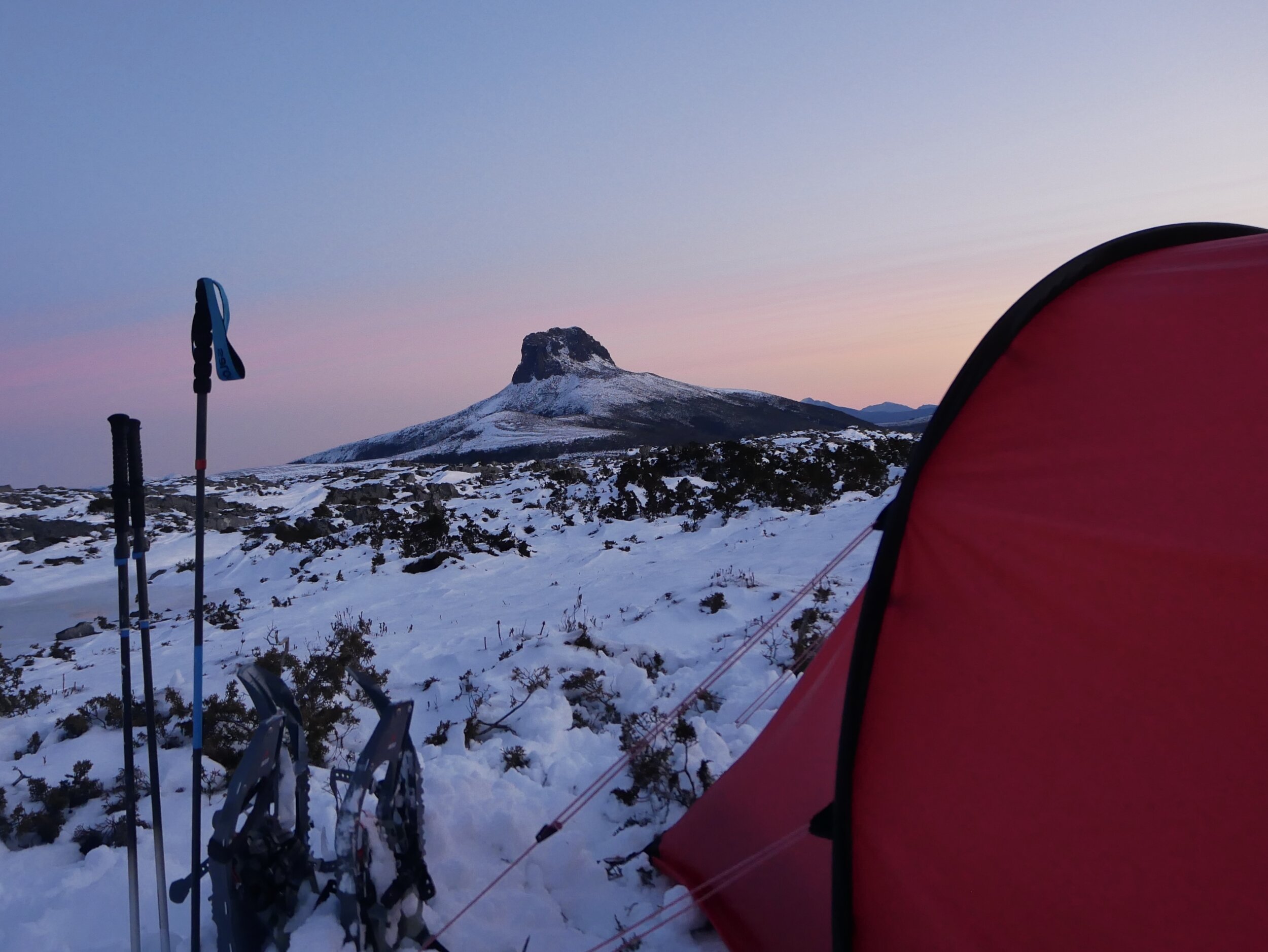
Camp for the night looking towards Barn Bluff.
After 2.5 hours from Kitchen Hut we had reached our lofty goal! Our previous summit time from the hut was 55 minutes in summer, which shows the increase in degree of difficulty in winter. Even without our numerous photo stops we estimate it would still be close to 2 hours - so double our summer trip time.
Mind you with clear blue skies, no wind, warm sunlight and snow as far as the eyes could see, this trip was totally worth the extra time taken.
We had uninterrupted views of Fury Divide, Barn Bluff, Mt. Inglis and Frenchmans Cap to name just a tiny bit of the views! With lots of time for our return journey we could sit back and enjoy a leisurely lunch with views all round. After lunch it would be time to descend and then begin our wintry jaunt to the new Waterfall Valley Hut for the evening. Bliss!

Mount Emmett on the way to Waterfall Valley Hut.
The stats.
Distance: Approximately 6km from Dove Lake.
Time taken: Approximately 8 hours. That's winter times with much of the route in snow and ice. Expect to be a bit quicker in dry/summer conditions, but still allow the best part of a day.
Difficulty: In perfect summer conditions we would classify Cradle Mountain as medium to hardish - don't underestimate the boulder scramble towards the top, especially if you're not confident walking on steep rock. During snow conditions like this particular day, we would up-rate this to difficult. In unconsolidated snow or heavy ice the route becomes very difficult to impossible without specialist gear/experience and isn't recommended unless you really, really know what you're doing.
Type of track: Well-defined track/pad mostly with ski pole markers over the boulders.
Access from: Dove Lake carpark.

Route taken to Cradle Mountain.