Mount Inglis
Date: 18th January 2020 – Summit: 1281m
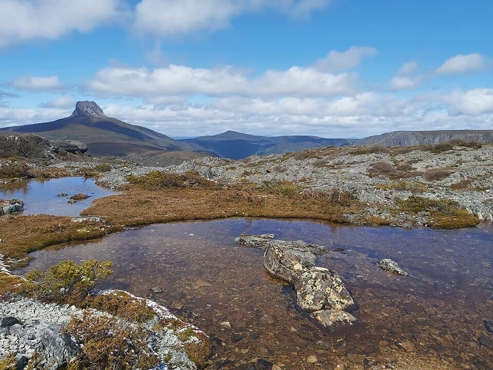
The very low profile of Mount inglis in comparison to Barn Bluff. Photo Credit: Ben Young
Wandering along The Overland Track, many a hiker has admired the views of Cradle Mountain and then Barn Bluff on approach to Cradle Cirque. But, off to its right as you approach the Barn Bluff junction lies a much lower, and much less distinctive peak - Mt. Inglis.
Although often ignored because of its imposing neighbour, Mt. Inglis is worthy of climbing if for no other reason than to stand atop its summit and embrace the feeling of total and utter isolation. Its beauty is its remoteness and that same remoteness is also what creates its challenges.
Given the distance needed to be covered, most sensible people climb Mt. Inglis as part of a multi day trip along the generally accepted route from the base of Barn Bluff, as described by the Abels Book. However, the good book also states that it would be possible for "very fit" walkers to climb Mt. Inglis as a "very long" day trip from Dove Lake. Now I am anaemic with little legs - not the definition of "very fit" that's for sure! Nevertheless what I have in spades is a sense of adventure and determination. It would be that sense of adventure that inspired me to summit via Lake Will instead of via Barn Bluff. A friend would be joining me for the 15 hour long day hike.

The very underwhelming summit cairn of Mount Inglis.
Why not watch & read?
Please enjoy a visual trip to Mount Inglis in addition to the blog below. Whilst the blog gives you greater detail on the trip (including route information) the video allows those that may never reach its summit a virtual experience.
My walking buddy and I had committed to two things for this hike. One, we would summit it from Lake Will and two, we would attempt it as a long day walk. Months earlier we had planned on climbing Mt. Inglis as part of a multi-day trek but freak spring snow had scuttled our plans. Back in October when originally planning this trip, we had poured over maps and satellite imagery and marked out a route from Lake Will that we thought would provide the easiest passage. As it turns out our route was spot on - it‘s just a pity we ignored it to our detriment on the ascent!
Reverting to our original plan for the descent from the summit meant we enjoyed a route to Mt. Inglis from Lake Will that was fast, easy and most importantly it almost entirely cut out ANY scrub bashing!
Setting off on foot around 4:00am from the Dove Lake car park under cover of complete darkness was eerie. Just our two head torches and total stillness. No wind, no noise, barely a moon. Not wanting to extend an already long day we took the "fast and nasty" track - known as the ‘Chains’ Track - to the top of Marions Lookout, and in just under an hour and a quarter had reached Kitchen Hut. By this point it was light enough to switch our head torches off but a thick mist enveloped everything other than the path ahead.
After reaching the junction for Cradle Cirque and Barn Bluff we stopped to layer on our wet weather jackets as the mist was now a drizzle. The weather wasn't looking promising but we had faith it would shift. As we wandered Cradle Cirque the sun attempted to shine through pockets of cloud over Mt. Emmett creating a surreal skyscape. The ridiculously early start was worth it for this view alone. From the Dove Lake car park to Innes Falls where we would cross the Bluff River was approximately 17km. We continued on towards Waterfall Valley Hut. From there we would proceed until the track junction for Lake Will.
Arriving at the junction to Lake Will in just shy of four hours, we decided rather than stop and make coffee and have breakfast, we would push on. We had nibbled some yummy fruit buns while walking and coffee would be a great reward at the summit! We were eager to see Lake Will as we had only ever seen it from the top of Barn Bluff before.

Lake Will. Photo Credit: Ben Young

Innes Falls at Lake Wills. Photo Credit: John Ralph at Ascent Fitness.
Lake Will did not disappoint with its crystal clear water, mini sandy beaches and pockets of enchanting pencil pines. The sun was shining and it was now warming up, so the ice cold water made for a particularly refreshing drink! An obvious pad led from the eastern side of the lake all the way across to the south western side and arrived at Innes Falls.
We were well ahead of our schedule when we reached Innes Falls to cross the Bluff River and so spent a little time having a snack and exploring the area. The falls are easy enough to cross with two distinct crossing points. The first point crosses almost at the exact junction where the falls drop off a small cliff. An easy step but if you slipped with less than a metre to the sheer drop it wouldn't end pretty! However some rocks a few metres upstream bring you to safe crossing point.
There is good reason to cross at the rocks just upstream, for here starts an easy route to the spur of Mt. Inglis. Immediately upon crossing the falls and climbing the few steps up and away from the falls you are presented with two pads - one leading to the left (somewhat hidden behind a crop of bush) and another leading to the right. Choose wisely - choose left! We found this out the hard way. The pad to the left combined with our route will get you to the spur of Mt. Inglis without encountering scrub or scorparia! The pad to the right will also get you to the spur of Mt. Inglis (joining the Barn Bluff route at Fury Divide) but in a much more difficult manner.
We of course didn’t know any of this beforehand, and so our ascent started with the right hand pad as it was very distinct. If one doesn't know the left pad is there it‘s easy to miss as you cannot immediately see it.
Off we headed to the right following the obvious pad. We had our eyes on the prize and for now the walking was effortless. Low alpine heath underfoot with an endless choice of animal pads. Great we said to each other - if it’s like this all the way we will be there in no time. How wrong we were. Keeping Lake Will on our right we gradually started heading in the direction of Mt. Inglis, climbing the first gentle rise after the falls, but ensuring we kept south west of the obvious knoll and elevation gain. We weren't interested in adding extra hard work on top of an already ambitious day. Our goal at this stage was the moor at the base of the Mt. Inglis spur.
The many Mt. Inglis blogs and trip reports we had researched, as well as The Abels book itself, had bemoaned the presence of pockets of dense scrub and scoparia in the journey to the spur at the base of Mt. Inglis. We were not naive enough to think we could avoid it all but hoped if we crossed somewhere between the narrowest part of greenery close to the Barn Bluff route The Abels book refers to, we could save ourselves the worst of the scrub bashing.
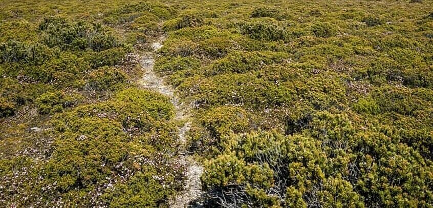
Our animal pads and ankle height alpine heath began to change into low button grass and flowering scoparia. Not dense enough yet to create any difficulty but certainly not as easy as the first kilometre had been. We were loving the many colours of flowering scoparia on offer with a particularly pleasing soft pink on display. The admiration soon turned to misery as we crested the hill to an unending and unavoidable section of dense scoparia around chest height. Beyond this we could see the band of snow gums we would need to work through. There was nothing else to do but commence our prickly path into the forest.
Scoparia gave way to snow gums and chest high scrub. Given the amount of scrub bashing we have done over the last few months we would not call this section challenging, but it was hot hard work after already having covered around 18km. We concentrated on keeping as close to the Barn Bluff route as possible without gaining unnecessary elevation.
It was with much relief that we finally broke out into a section of myrtle forest with a soft, spongy green ground covering under foot. The pushing and shoving was now relatively non-existent, but the acrobatics of climbing over and under myrtle forest was in full swing. The myrtle forest did however bring with it much welcomed shade from what was now direct sunlight and heat. We were both saturated with sweat from the physical exertion.

Some of the scrub encountered. Photo Credit Ben Young.
Alas the shade wasn't to last! Once again it was time to push and shove through dense bush only now it was also combined with scoparia that was well above my head! Not only that but the ground underneath was riddled with hidden holes. No sooner would we use brute force to push through head high scoparia we would fall into holes on the other side of it! So much fun. The once visible spur at the base of Mt. Inglis had now disappeared from sight, so we could not wait to break out of the monstrous bush if for no other reason than to see our goal for the day.

Looking towards the spur that would take us up onto Mount Inglis.
Saying we were both pleased to leave the band of scrub and scoparia behind us would be an understatement. We were elated. From our vantage point just above the moor it looked like a mere hop, skip and jump to the summit. Wrong again folks.
Crossing the moor was rather easy as the ground cover was low with many an animal pad to follow. The only challenge on this section was the fact that some areas were extra boggy meaning we would sink, boots and all, into the mud. We could see ahead the band of scrubby myrtles and snow gums that lay behind yet another band of scoparia. The joy.
The Abels book mentions circling the spur a little to the south to avoid the worst of the scrub. We thought we were well south but still encountered rather hideous scoparia hiding boggy marsh followed by comparatively dense snow gums and myrtles. It was a matter of just keep on pushing! Yet again we were looking forward to breaking out of the dense bush to allow visibility of the summit, but at least the elevation was climbing quicker now.
With the trees thinning above us and sunlight again breaking into the canopy we knew we would crest the spur soon. Popping out of the forest we located a small cairn with a very distinct pad leading towards the summit behind it. Excitedly we pushed on thinking this was our yellow brick road home. Nope - it disappeared into thin air - or rather, thick scrub - not long after it began, but we were now only about 500m from the summit.
The short lived but very obvious pad leading to the summit approach.
Much to our surprise, the very final climb to the summit was far steeper than the view for the past few hours had let on. Short and very steep. So steep in fact that we were using the low scrub as hand holds to drag ourselves up. There was no exposure due to the climb being covered in low scrub. A weird mix of scrubby cliff!
Dragging ourselves up the last few metres we were at last standing on the summit plateau. A short walk to the north and we were touching the summit cairn! Yay! We had aimed to stand on the summit around 1pm and it was only 11:30am. That meant we had time to sit back, brew some coffee and soak in the views. Seven hours, 21km and a well earned coffee and feed.

The summit plateau area of Mount Inglis.
The actual summit plateau of Mt. Inglis is underwhelming but the views it commands are anything but! Looking out from Mt. Inglis Barn Bluff resembles a pointy Mt. Ida! Looking out over endless valleys and mountains reminds you of your own insignificance in the world. The feeling of isolation standing on top of Mt. Inglis is intense but in a calm, almost tranquil sense.
However, views aside, we had an enormously important task ahead of us - finding an alternate route back to Lake Will as there was no way either of us were returning via the sea of scoparia we had fought on the ascent! The few minutes we spent scouring our maps, reviewing our original route and setting new compass bearings over our coffee enabled us to return fast and free of scrub bashing. Like free of any scrub bashing AT ALL. To anyone reading this - enjoy our gift.
Our return route needed one thing - to absolutely minimise the scoparia and scrub bashing we would do. Pouring over the paper maps and satellite imagery we had bought along, combined with Avenza maps on our phones, map infomation on our Garmin InReachs and our birds eye view from the summit we selected our course home. Pulling out my trusty compass we noted some bearings, thanked the mountain for letting us climb her, and started the long trek home.

A close up of the vibrant green patch we set our compass bearing for! Photo Credit: John Ralph at Ascent Fitness
Our way off the summit plateau would be much the same initially. Dropping down off the edge we located the pad we had followed up and continued along this pad almost entirely to the one and only cairn marking the entrance to the scrub at the edge of the spur.
The pad was easier to see on the return journey and we had left ourselves some ruben tape for the return journey which we stopped to collect. After collecting our two tape markers we changed direction swinging to the very southern side of the pandani and myrtle forest to descend the spur.
We had noted from our elevated point on the summit that this would allow us passage outside of the scoparia band and indeed it did! Following this route we were back at the moor at the base of the spur in record time having totally avoided the band of scoparia and dense bush we had faced on that section on the ascent. Tick.
Next, instead of sticking to the high road on Fury Divide (ie. the Barn Bluff route) we had set bearings for as low as we could go! We crossed the moor at the base of the spur until reaching the obvious and natural valley, dropped down into it and started walking south-easterly.
Sticking on the contour we had chosen we were able to cross the vegetation divide (scoparia and snow gums) at a point where there was a natural absence of it all!! It was merely low alpine scrub intertwined with animal pads. The trick is to not drop to the creek (too low and you will hit scrub) and not to climb up a contour line (too high and you will hit scrub). Gravity was no doubt helping our progress, but we couldn't believe how easy it was.
We were chatting, following very distinct animal pads and enjoying the easy hike homewards to Lake Will whilst, at the same time kicking ourselves for not trusting our instincts and using our own route on the ascent. We were down off the summit, past the spur, over the moor and approaching a large area of what looked like a strange bright green cushion plant like ground covering which we suspect is Scleranthus biflorus. We had viewed this spectacular green oasis from the summit meaning we were exactly where we wanted to be. Happy dance. We were almost back to Lake Will and it had been enjoyable, easy and quick!
When Lake Will came clearly into sight we changed direction to almost due right heading to the edge of the cliffs at Innes Falls instead of to the edge of Lake Will. This ensures easy walking... a nice view to the south too!
Not only was the large area of Scleranthus biflorus charming to walk across it covered a network of tiny below-ground creeks. Cool, crisp running water to refill our bottles and now heading over to the small tarn on our map now wasn't necessary. From here we would continue on the same contour line winding through low button grass and along animal pads towards Lake Will.
When Lake Will became clearly visible and we stood just past two lone and large Pandani's we made a premeditated change of direction. Instead of walking directly to the western side of the lake we now headed south-easterly until we hit the cliff line of Innes Falls. This allowed us to avoid any unnecessary kilometers or scrub.
The two large pandani we had viewed from the Scleranthus biflorus area led us to a point where we could see the gravel like rocks of the cliffs for Innes Falls and that was our cue to head directly for them. From here it was even easier walking along the shale like cliff to the crossing at Innes Falls! Imagine our surprise to see a pad leading to the crossing. We were also from this vantage point to see the very distinct pad leading (or rather misleading) off to the right from the falls! Crossing the falls we started the final 17km leg back to the car via the Overland Track.
Immediately after crossing Innes Falls you will climb out of the crossing a few steps to a spot where a small band of bush is on your left as you look towards Barn Bluff. DO NOT FOLLOW THE RIGHT HAND PAD. Instead locate the less distinct pad leading to the left and an eventual gravel/shale cliff area.
After crossing the falls follow this pad leading left towards the gravel like area above Innes Falls.
Follow this cliff line until you are almost at right angles with two large Pandani trees off to your north and that’s your cue to start the hike to Mt. Inglis!
Our Mt. Inglis adventure was epic. We call it our Mt. Inglis Marathon given it was an almost 43km round trip and a solid 15 hour day. What we really love about it though is that using our return journey route our many Abel bagging friends can now enjoy a quick and easy hike to Mt. Inglis from Lake Will. The hard slog is from Dove Lake to Lake Will due to the distance covered. But imagine a wonderful few days spent camping on the shores of Lake Will with an easy day summit of Mt. Inglis included - bliss!
The stats.
Distance: Approx. 42km out and back.
Time taken: 15 hours as a very long day hike including numerous short stops for photos and lunch.
Difficulty: Very difficult as a long day walk from Dove Lake car park, simply for the distances involved. As a (much) shorter day walk from a campsite at Lake Will, we would classify it as easy-to-moderate if the right route - avoiding virtually all the scrub - is followed.
Type of track: Completely untracked from Lake Will.
Access from: Dove Lake Carpark.

Route taken to Mt. Inglis from Dove Lake via Lake Will. Note the more southern route west of Lake Will taken on the return journey.