Mount King William I
Date: 14th March 2020 – Summit: 1324m
Photo Credits: Ben Wells, Tracey Orr

The King William Range from the Lyell Highway.
We had previously completed the royal tour of Volume 1 of The Abels (Mts. Albert and Victoria) and so it seemed suitably fitting that our first Abel from Volume 2 should be another royal - Mt. King William I. Well that and the fact that we were heading to the shack, wanted to chase some snow and only had a few hours spare to indulge in our addiction of Abel bagging. And what a splendid snowy time we had.

King William Range from Lake Dixon.
Why not watch & read?
Please enjoy a visual trip to Mount King William I in addition to the blog below. Whilst the blog gives you greater detail on the trip (including route information) the video allows those that may never reach its summit a virtual experience.
Mt. King William I is the northern most pinnacle of the King William Range and access to the beginning of the climb is from Harbacks Road. We parked the car in the small parking area on the gravel road not far past the boom gate. We were excited to see Mt. King William I had a decent dusting of snow on it as we drove onto Harbacks Road. Our first snow hike of the season! The Abels book recommends care in deep snow due to the possibility of small cornices forming towards the summit but the snow was only light on the ground. Whilst we were excited about the snow, we weren't enthused by the amount of mist settled over the summit. There was every chance there would be no views today. Mt. King William I looked pretty but the standout was Mulligans Peak to its side. Sharp, pointy and almost completely overshadowing our object for the day. We mused another day in better weather we would return to stand on top of Mulligans Peak too.

The boom gate on Harbacks Road at the start of the 4WD track.

The initial section of 4WD track leads through open areas.

A snow topped Mt. Rufus could just be made out to our north.

The 4WD track alternated with rock sections of widened trail.
Prior to leaving Launceston at 5am that morning we had loaded our mountain bikes onto the back of the Mazda as we knew that there was approx 4km of old 4WD track to wander up before reaching the single trail. We thought it may be possible to ride it and save some time. We had tried the old "bring the mountain bikes it will save us time" trick before on Collins Bonnet, Trestle Mountain and Mt. Marian and it had severely back fired so we planned on making a final decision only after a little recon of the track! As I was booting up, Ben took a short walk past the boom gate and decided bikes would be a hindrance, not a help, so they were left on the bike rack.
Slipping around the first boom gate we stepped onto the old 4WD track. The wide and very boggy track led through open eucalypt forest and past a small button grass plain. To the north we could see Mt. Rufus was also dusted in snow and had a misty haze settled over it. The 4WD track was rocky, clay-like and very boggy in places from recent rains. It gradually climbed upwards but nothing that really created too much exertion.

Recent rains made for a wet and boggy trail.

Scrub encroaching on the 4WD track and a creek flowing down the centre of it.
The 4WD track continued along gradually but consistently increasing in elevation. As it climbed higher the vegetation changed to include a few pandani, bauera, snow gums and peppermints. It would narrow and then re-widen but was always wet underfoot. Climbing up towards the second boom gate (approx 2.5km along the 4WD track) the ground underfoot became more rocky, with some of the rock smoothed by what appeared to be a small creek running down the centre of track.

The second boom gate on the track.

Mt. King William I hiding in the mist.

The track levelling out briefly before beginning to climb again.
Passing by the second boom gate the track got a little steeper and then momentarily plateaued out as it cut through a large button grass plain. Still the summit area was covered in mist but the mountain was now appearing a little more imposing and we could see there was a steep climb ahead of us! After plateauing for a few hundred metres the brief climb up towards the log book began and we started to see the first evidence of snow on the ground. Happy dance!

Climbing higher heading towards the log book at the base of the single track.

The first signs of snow.

Snow starting to cover the foliage as we neared the single track.
The log book is located at the bottom of the single track where the 4WD track finishes. We were surprised how long the 4WD track went for - over 4km. Once our intentions were logged we donned our wet weather pants. We already had our upper body outer shells on as it had been lightly raining on and off all morning. We could tell the scrub was crowding in on the single track and given the amount of snow on the track and on the surrounding vegetation we were bound to get wet and cold without our wet weathers on. Slipping on our waterproof scrub gloves and it was time to tackle the mountain climb!

The log book and the start of the single track to the summit.

Well padded track but lined closely with scrub.

As we climbed higher the snow cover began to increase.

Steep single track leading up to the moraine.
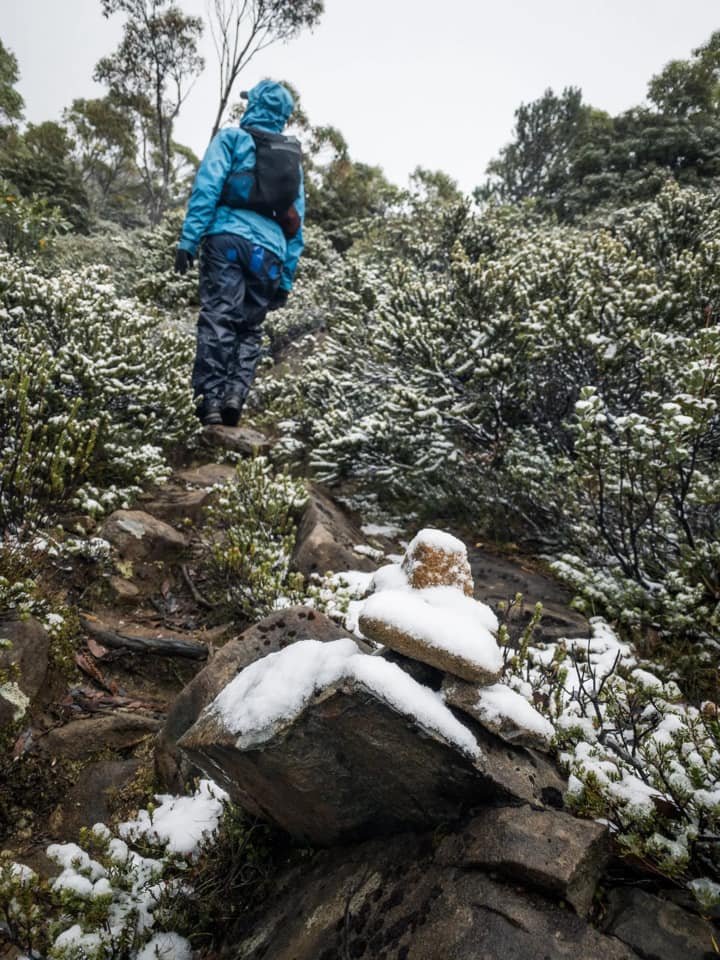
From the very moment we stepped onto the single track the elevation increased markedly. We both had tired legs from summiting Mountains of Jupiter and Twin Spires the weekend prior and so were feeling every bit of the now steep climb! Due to the amount of snow laying on the track we were paying particular attention to our footing. The ground was a combination of well padded forest floor mixed with embedded rock. During fine weather the embedded rock would make great foot holds but during snowy weather it creates a track that needs a little more concentration. The occasional cairn and pink tape marked the track as it climbed higher.

Lake George.

Traversing the moraine on the track to the summit.

Mt. King William I's imposing eastern cliff face.
After a couple of hundred metres of climbing the track levelled out briefly and we could see Lake George in the mist to our South East. Ben had stopped to take some photos of the lake as I continued on and then - wow! The imposing eastern cliffs of Mt. King William I were now visible. With snow settled on the track, sprinkling the low vegetation with a white dusting and the dark, grey and moody cliffs towering over us it was a surreal feeling. I was excited to see the top but from this vantage point it seemed like a very steep, almost an impossibly steep climb to the summit area. I was also a little nervous that the weather might steal a summit from us if it worsened. The moraine we were traversing left us exposed to the wind which was bitterly cold and it was also again gently snowing.

Snow covered cairns scattered the trail.
Reaching the base of the final climb towards the summit.

One last ridge to scramble up!

Snow covering rocks on the trail made for slower progress up the final steep ascent.
Starting the final ascent from the moraine to the summit we were once more sheltered from the worst of the wind and although it had looked particularly steep from below the eastern face it was surprisingly quick from that point to the summit plateau. Our Garmin inReaches confirmed we only had approximately 100m to the summit.

About to crest the summit plateau.
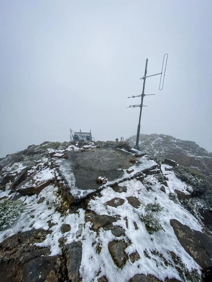
Looking back from the highest point towards the man made installations.

The steep drop on the western side of the summit.

No views today but the eerie sense of looking into an abyss.
Whilst the final push was very steep it was also very short lived. The snow on the ground made the last rocky scramble to crest the summit a bit sketchy but soon enough we were staring at the helipad, the solar panels and the sheds and ariels that are spread around the summit area. The summit was very exposed and with snow still falling and the wind blasting across the open summit area we made haste towards the high point located beyond the man made installations.
Sadly we would be denied a view from the summit today but we were OK with that to have enjoyed our first snow hike of the season. We may not have enjoyed distant mountain views but we were spoilt by mother nature putting on such a snowy show. We love to hike in a winter wonderland and had missed the snow over summer. Next summer we might return to Mt. King William I to enjoy its views but for today we thanked the mountain for letting us climb her and the weather gods for giving us the snow we had come chasing. It was time to head down off the mountain and towards the open fire at the shack beckoning us.
The stats.
Distance: Approx. 11km return.
Time taken: 3.5 hours return including multiple breaks for photos, a quick snack on the summit and numerous stops to enjoy the first snow of the season. The Abels states 2.5 hours each way.
Difficulty: Easy. A combination of old 4WD track and single trail to the summit, with only the latter putting up a steep climb over a short distance. Cairns and the occasional ruben tape but the pad is so obvious it barely needs either. Due to the light dusting of snow some very small sections of the track were covered.
Type of track: Tracked all the way to the summit.
Access from: Harbacks Road, off the Lyell Highway just west of Derwent Bridge.

Route taken to Mount King William I