Mount Olympus
Date: 24th October 2020 Summit: 1472m

Mount Olympus from the shores of Lake St Clair at Narcissus Bay. Photo Credit: Parks & Wildlife Service.
We all know I am in love with Greek mythology, so any mountain named after the very home of the Greek Gods themselves was inevitably going to grab my attention. Even without its captivating name, Mt. Olympus commands your interest as its massive form rises above Lake St. Clair, its bulk spread out over a lumpy, tumbled rocky ridge between its two opposing cliff plateaus.
When the opportunity arose to visit Mount Olympus with the Pandani Walking Club I jumped at it. For me there is no better way to spend a few days then enjoying good company, a physical challenge and breath taking views. The views may have escaped us this trip but the company was mighty fine as was the physical challenge.

Camp at Echo Point Hut the night before our trip to Mount Olympus.
Why not watch & read?
Please enjoy a visual trip to Mount Olympus in addition to the blog below. Whilst the blog gives you greater detail on the trip (including route information) the video allows those that may never reach its summit a virtual experience.
Day 1 - Cynthia Bay to Echo Point
The plan was to meet with the Pandani crew at Cynthia Bay and then set off for Echo Point from there. We were going to enjoy a night's camping at Echo Point to break up the trip before heading off the next morning to Lake Oenone to make camp again. Depending on the daylight hours we had left upon reaching Lake Oenone, we had also tossed around ideas about camping at the summit of Olympus - weather permitting.
To save a very lengthy blog, my trip report will start at Echo Point rather then recount my travels in detail along The Overland Track. However, it is worth mentioning that this section of the Overland Track is incredibly beautiful. If you are ever doing the OLT, skip the ferry and walk the final 15km or so. It is well worth it.

Sunset views across to Mount Ida from Echo Point Hut.
Day 2 - Echo Point to Lake Oenone
After a lovely evening watching the sun set over Mt. Ida and an eventful night, where the infamous Echo Point rats chewed a big hole in my brand new Tarp Tent, we were all packed and ready to go at around 8am. With our trip leader Ian in front, our merry band of walkers stepped off north along the OLT. We would walk for approx. 1.6km and cross over three man-made bridges in quick succession before looking into the scrub for our step off point. From that location forward our travels would be off track, steep and through forest and scrub. The joys!

Look for three man made bridges before heading scrub bound!
Almost immediately after crossing the third of the three man-made bridges we headed west into the scrub. A very faint pad is discernible at the step off point, but no cairns or ribbons indicate its location. The climb upwards began almost instantly, but the going was relatively easy due to the open rainforest. Perhaps the most difficult part of this section was the slippery moss cover that blanketed the forest floor. Ian and Grahame were leading, Pete and I in the rear. The faint pad quickly disappears a few metres in, but I noticed we were sticking within earshot of the unnamed creek on our south.
Picking the path of least resistance we continued upwards until we were prevented from going further by a small rock shelf. Skirting to the right at the base of the rock and climbing over a few fallen logs on the way we sighted a small piece of pink tape on the shelf, highlighting the easiest route to the top of it.
This would be the earliest of a few rock scrambles on the way to Lake Oenone and by far the easiest. With only a gentle gradient and plenty of hand holds we were able to leave our packs on and pull ourselves up the short climb - about now I was glad that I had packed lightly for this trip. The climb was steepening and the day was warming up.
The debris on the forest floor was increasing in line with our elevation. It would not be long before we would reach the first of two more substantial challenges on the way to Lake Oenone. What we had covered already was more scramble than climb, but we still had the small cliffs sprinkled through the route to navigate. Lucky for us ,Ian had visited Mt. Olympus recently and had not only his GPS route saved, but also some trusty rope and a sling for the sections where we would need to pack haul!

Pete negotiating one of the smaller climbs.

One of the bigger climbs where pack hauling came in hands.
Arriving at the most difficult of the cliff climbs (hint; look up and you will see a small piece of pink ribbon indicating the best chute) we decided that we would be best to pack haul the packs up. Whilst there were a few hand holds, the combination of slippery rock and heavy packs on your back is never great. Ian would climb up first to secure the rope followed by Grahame who would hand up the packs and then like little ants up a tree we would complete the climb single file. Whilst heights are not my thing, I was surprised to admit that I enjoyed the scramble up (I realise after doing the Western Arthurs that this was so not high!). Just knowing I had the rope if need be gave me a level of confidence.
Until this point we had enjoyed the luxury of relatively open rainforest, but that ended abrubtly as we found ourselves pushing uphill through thick baurea making the going slow and arduous. Locating a large fallen log it was time to break for lunch before the final grind to Lake Oenone.

Me trying to snap Graham before the scrub ate him again!
From our lunch spot, the density of the scrub increased markedly. Weaving, pushing, back tracking and bashing, we continued on through dense patches of pandani, scoparia and cutting grass. With relief, we would break out of the dense scrub briefly, only to be met by it again moments later. Our target was the moraine ridge above Lake Oenone. Our progress had been slowed by heavy packs, a warm day and in many places thick scrub. It seemed more likely that we would be making camp at Lake Oenone rather than the summit. I think we were all glad to reach the arch of the ridge and slightly more open walking along the faint pad.
Looking down upon Lake Oenone was a welcome sight. Unfortunately our sun had disappeared, leaving in its wake mist and light drizzle. The northern highpoint was completely hidden in thick mist. There would be no summiting today. If we were lucky we might get the tents up before the mist turned to actual rain.
Oympus North

Olympus rising above Lake Oenone

Fagus, Mount Olympus and Lake Oenone. Bliss!
We had made camp late in the afternoon the previous day and any hopes of summiting Mt. Olympus had been stolen by the weather gods. So we had instead decided to summit early the next morning after breakfast, and then hike back to Echo Point if the weather hadn't improved. It was cold and drizzling slightly as we set off. Peter has previously summitted Olympus North, but not its Southern highpoint, so he was waiting back at camp to see if the weather improved to allow the trek.
Light drizzle surrounded us and the summit was invisible behind the mist as we set off, but we were determined to make the summit before our trip came to an end. Leaving the lake behind, we climbed once again onto the moraine ridge that would lead us to Olympus North. Once back on the ridge, we picked up the pad that we would follow all the way to the bottom of Olympus' cliff line. The pad was distinct for the most part, but small sections took a little more concentration to keep in sight. As we climbed higher the occasional rock cairn started to make an appearance.

The beautiful fortress like cliff face of Mount Olympus.
Mist swallowed all our forward views, but for a brief moment the sun forced its way through and we could glimpse Lake Helen below. Hopes of a clear summit were dashed by the sprinkling of very light snow as we arrived at the rocks at the base of the summit plateau. Even though it was wet and misty, it was not difficult to negotiate the boulders. They were for the most part a very agreeable size and the route well cairned. The sheer cliffs rising above us were eerie in the mist and gave a sense of drama to the scene.
The cairns led us on contouring around the cliffs. It is important to locate the right break in the cliff line with which to approach the summit plateau. The first obvious break in the cliff line has quite a distinct false pad leading towards it. Obviously where past adventurers had been led astray. When you sight this first pad leading up to the cliffs instead keep contouring north, look out across the broken rock and you will see a cairn at the base of a very well padded and easy chute. Pick this one!
Locating the right chute allowed us to make short and very easy (and safe) progress breaching the cliffs and stepping out onto the Olympus summit plateau. The weather was getting worse and between the wind and the snow, we were all pretty glad our camp for the night had been at a lower elevation. Had we camped up there, we would have been tent bound for sure!

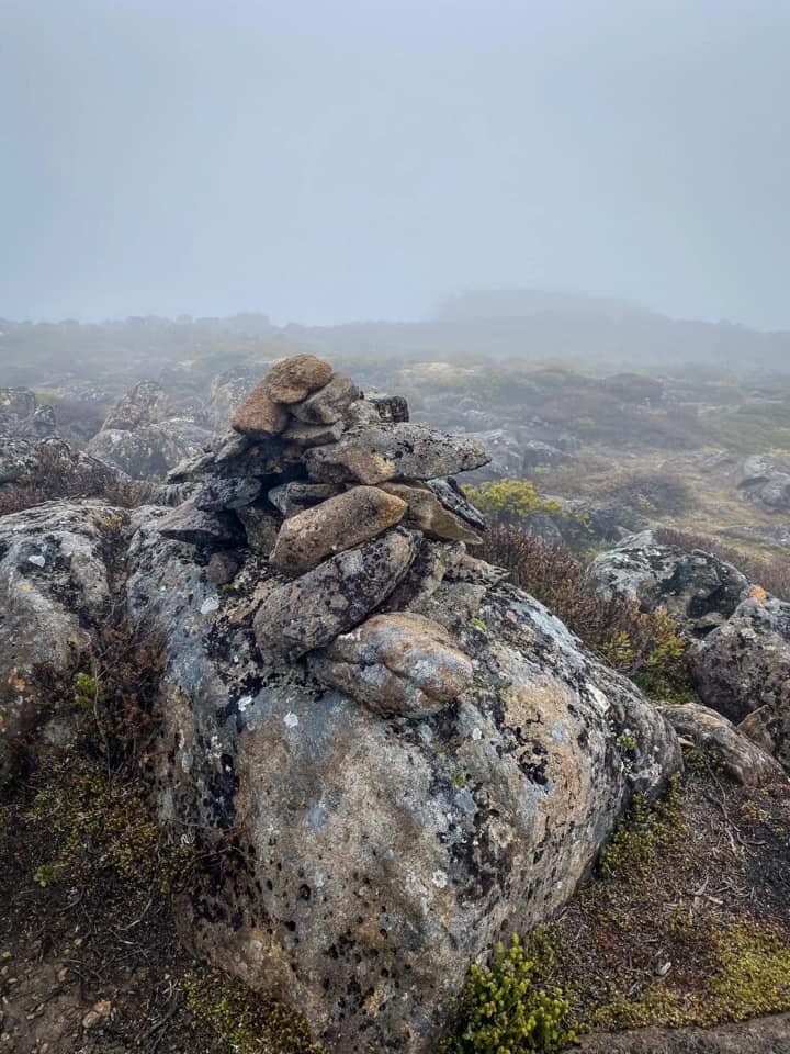
The stunning but foggy summit plateau. Note the cairn.
With the weather deteriorating we took the time to layer up before pushing across the plateau to the high point. The plateau would be a delightful place to spend a sunny afternoon exploring. With its scattered tarns, delicate cushion plants (take care where you step) and 360 degree views I can see why camping on the summit is much desired. For us we had sleet, snow, no views, cold, frozen tarns and wind! Believe it or not being the eternal optimist I am I was still hoping for sun at the summit and views!
The level of views we had and the summit cairn.
The walking was easy along the plateau. Weaving in and around the delicate cushion plants and tarns peppered with small rocky outcrops, we were soon touching the summit cairn with not a view in sight! Even after huddling down out of the wind behind the cairn for a while the weather had not changed, so it was time to begin the trek back to Lake Oenone. It would take us less than 40 minutes to reach camp such was our eagerness to get off the more exposed plateau and moraine ridge.
Reaching camp we discovered that Pete had not had the opportunity to visit Olympus South as the weather had not improved further down the plateau either. Whilst relaxing at camp he had met a group from the LWC who had made it as far as Lake Oenone, before turning around because of the weather.
With snow now falling intermittently, we decided to head back down to Echo Point where the others could enjoy more sheltered camping. Even though there were no views to be had it was a delightful way to spend a few days. Ian was an exceptionally capable group leader and him, Pete and Grahame were wonderful company.
As I walked the final 13km or so back to Lake St Clair from Echo Point that afternoon I was already planning a return trip. Whilst I would love to see the views from the summit what I would really love to witness is the turning of the fagus at Lake Oenone. What a spectacular scene that would be!
The stats.
Distance: Approximately 40km return from Cynthia Bay via Echo Point and Lake Oenone.
Time taken: We enjoyed three full days for this trip. It would be possible to do it as a VERY long day walk for those of well above average fitness or a fast pack overnight trip.
Difficulty: Difficult. The majority of this walk is untracked through often dense scrub. From Lake Oenone there are some faint pads and cairns, but care must be taken over the boulders to reach the summit plateau if they are wet or covered in snow/ice.
Type of track: Tracked along the Overland Track to Echo Point. Untracked to Lake Oenone and faint pads and cairns to the summit plateau.
Access from: Cynthia Bay, Lake St. Clair.

Route taken from Echo Point to Lake Oenone
The Map.

Route taken from Lake Oeone to Mt. Olympus return. (North).
The Map.

Route taken from Lake Oeone to Cynthia Bay.