Mount Sorell
Date: 12 November 2022 - Summit: 1144m
Photo credits: Ben Wells, Tracey Orr.

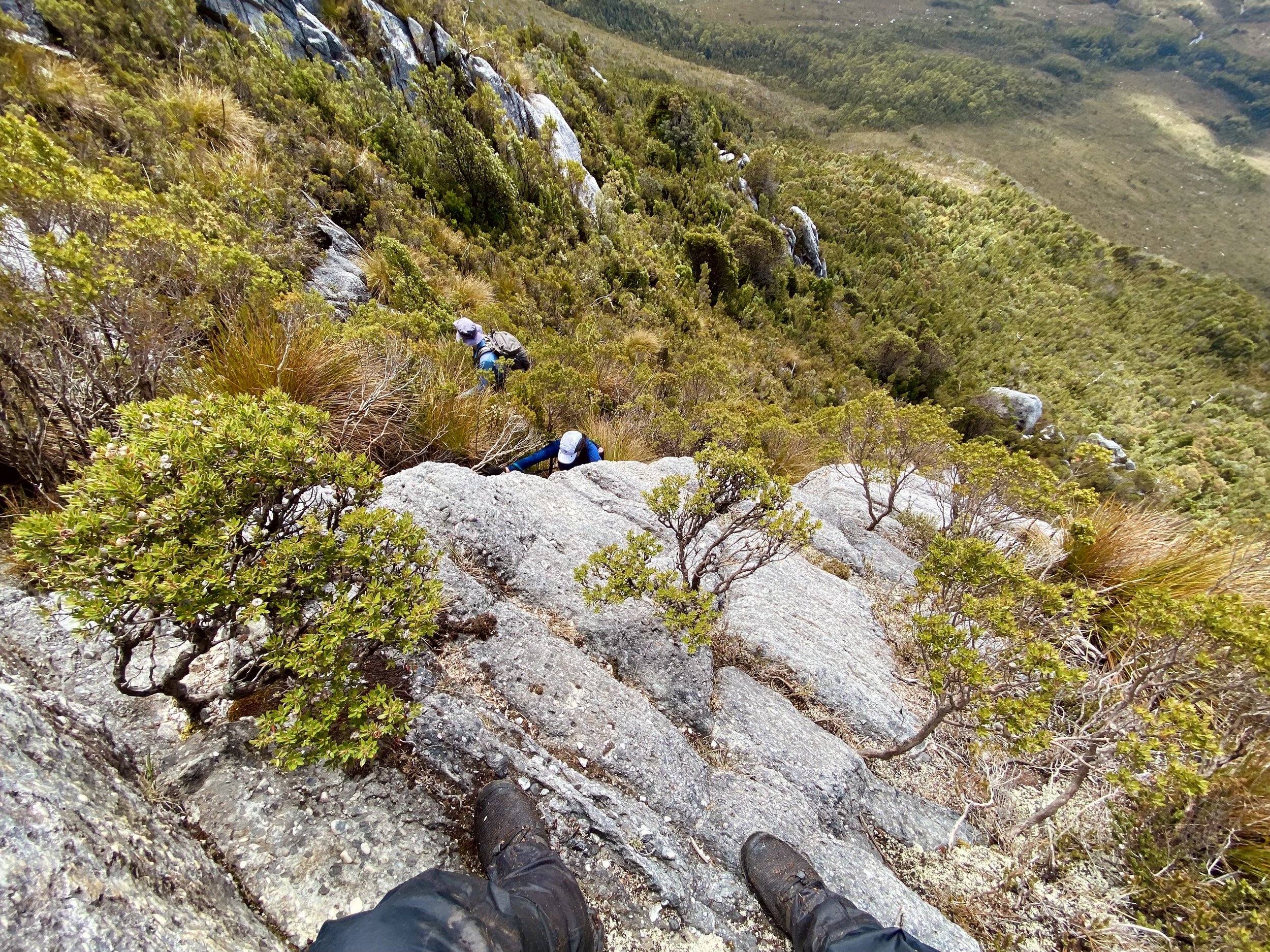
The final ‘final’ climb up Mt Sorell’s southern ridgeline.

Reminiscing the day’s adventure from our camp east of the summit.
Horror stories abound within the bushwalking community of a scrubby fortress protecting Mount Sorell’s sheer steep climbs that go on and on… and on and on! Well, dear reader, I can say firsthand that most of the stories are indeed quite true. But along with the challenges Mount Sorell dished out to us, she also generously served up glorious views, surprise trickles of cool refreshing alpine water and rare clear skies for summit day. It truly is magical when it all comes together.

The boys travelling up from Hobart - a four hour drive.
Exactly a year earlier, I spent a snowy 24 hours checking out prospective campsites and track conditions around Mount Sorell. Armed with this information we planned for a future trip, when time and weather would allow. We wanted - no, required - two things to give us the best possible chance of reaching Mount Sorell’s summit. Good dry weather for summit day, and longer daylight hours. This is not the mountain you do on a whim or in a rush.
Bender, Lucas and I were still a bit fatigued from the previous weekend’s bushwalking. Bender and Lucas had summitted Federation Peak (making it twice in one year for Bender) and I had completed a solo trip into Mount Bobs - both tough, exhausting trips. But the break in the weather was just too good to pass up, so an attempt at Mount Sorell was the go, tired bodies or not.
Along with Lucas, Ben Y also came for the ride (whom we’ve really enjoyed walking with on past trips) and Josiah, a mate of Lucas’s who has made many cameos in his videos. The two Ben's and Lucas would be coming from Hobart, I would drive in from Launceston and Josiah from Penguin.

Plenty of water flowing over Horsetail Falls, Mt Owen, as we pass through a very damp Queenstown after torrential rain.

The small car parking area off Kelly Basin Road.
With Friday off work, I arrived at the start of the fire trail around midday, having taken the long way round the north west of the state to Kelly Basin Road, due to flood damage across many of the roads. The plan was to walk in early and set up camp along the eastern ridge above the Clark River. The others would walk the 6km fire trail later that evening after work and meet me at camp. Most people walk the fire trail section, as the heavily eroded track requires a serious 4WD and a fair amount of nerve to negotiate, and likely wouldn’t be much faster than on foot regardless. Whilst its steep (you climb over 500m of elevation) it is easy walking - all gravel and rock.

Evidence of the recent rains and lovely Waratah in flower as I walked the 6km fire trail.

Scaling each of the steep hills on the way into the campsite.
I was looking forward to relaxing in the tent, reading before crawling into bed early so I was well rested for the Mount Sorell attempt the next day. Leaving the car in the small car parking area, I set off with my wet weathers on as the predicted rain for the day was already falling. About an 1h45m later I arrived at the campsite. What it lacks in soft dirt in which to drive tent pegs into, it makes up for with space! It would easily hold 10 tents or more, but note the gravel and rock is surprisingly sharp, so take a cheap tarp or similar footprint to protect your tent’s floor.
The rain had properly set in by now, and I was eager to get the tent up and get out the cold. I pulled the tent from the tent bag and removed the tarp. Opening the tent out, I realised within seconds that when Bender had bundled up the tent to give me for packing, he had grabbed up his TarpTent ProTrail Li one-person tent and not our Double Rainbow Li two person tent! I was now in the pouring rain, getting rapidly colder and had only a shelter I’d never pitched before and poles belonging to a different tent.. His very-much non-freestanding ProTrail Li uses his longer hiking poles to pitch and really isn’t suited to pitching on hard surfaces without pegs. Crap!

Gloomy wet conditions as I arrived at the campsite.

Worlds dodgiest pitch and it would not survive a puff of wind. Lucky the wind was non existent!
This is why you should always check your own gear yourself. His mistake, but mine also, as I had allowed someone else to organise my tent and not checked it personally. After using every possible swear word available to man, I realised I had two choices. One: walk back to the car and sit in it until the boys came in… after copping an earful over the InReach while at work, Bender had scrounged up Lucas’ old “supposedly a two-person” tent to bring in with him later that evening. Or, somehow, MacGyver the tent up as best I could. I took the second option.
Using large rocks, string tied to nearby shrubs and my hiking poles, I managed to just get enough tension across the tent to hold its shape - sort of. It would not withstand wind and it was wet through, but it was good enough for me to sit under at least! My relaxing afternoon had turned into a cold, wet and miserable nine hours, sitting in the middle of a rather small tent, holding it up. What do they say about challenges being character building?

Losing the race against the night - head torches on!
The boys arrived to camp around 9pm and we made record time of pitching all the tents. I had spent some of the many hours beforehand collecting water and piling up usefully sized rocks for them to use. As well as doing sit ups to keep my body temperature up! We agreed to set off at around 7am the next morning, knowing it would be a long and physically tough day, then wasted no time getting into bed. Lucas’ old Vargo barely seemed long enough for one human - let alone two - but I can’t convey how much of a relief it was to finally crawl into a dry, warm tent and bedding after a genuinely miserable afternoon.

Getting prepared for the day’s trek in the gloom of early morning.

Low cloud hanging persistently around the Mt Sorell ridgeline.
In the morning we discussed routes as we all ate breakfast, and how long the climb might take us. We knew it would more than likely be in the double-digits timewise, and we could potentially arrive back after dark. It ended up taking 11h20m in total, so we enjoyed a very pleasant hour of daylight for dinner when we finally got back to camp.

Descending down the remains of the old 4WD track towards the “trail head”.

Into the scrub.

Following the faint pad through increasingly high scrub.
Lucas was leading for the short road walk south and I yelled out to him to look out for a small cairn on the western side of the road that would indicate our step off point to head west into the bush. The cairn is small and set back, so you need to be actively looking for it. The next few hundred metres then involved following a sporadically taped/cairned route down towards the Clark River. It was very easy to lose the “track” as its barely marked and infrequently used. At one stage we wandered off it, which resulted in us forcing ourselves through a short section of dense bush only to pop out back out on it and pick up the now-obvious pad again!

Lucas all smiles as we drop down into the valley of the Clark River.

Weaving through baurea.

Early blooms of summer wildflowers as we followed the trail downhill.
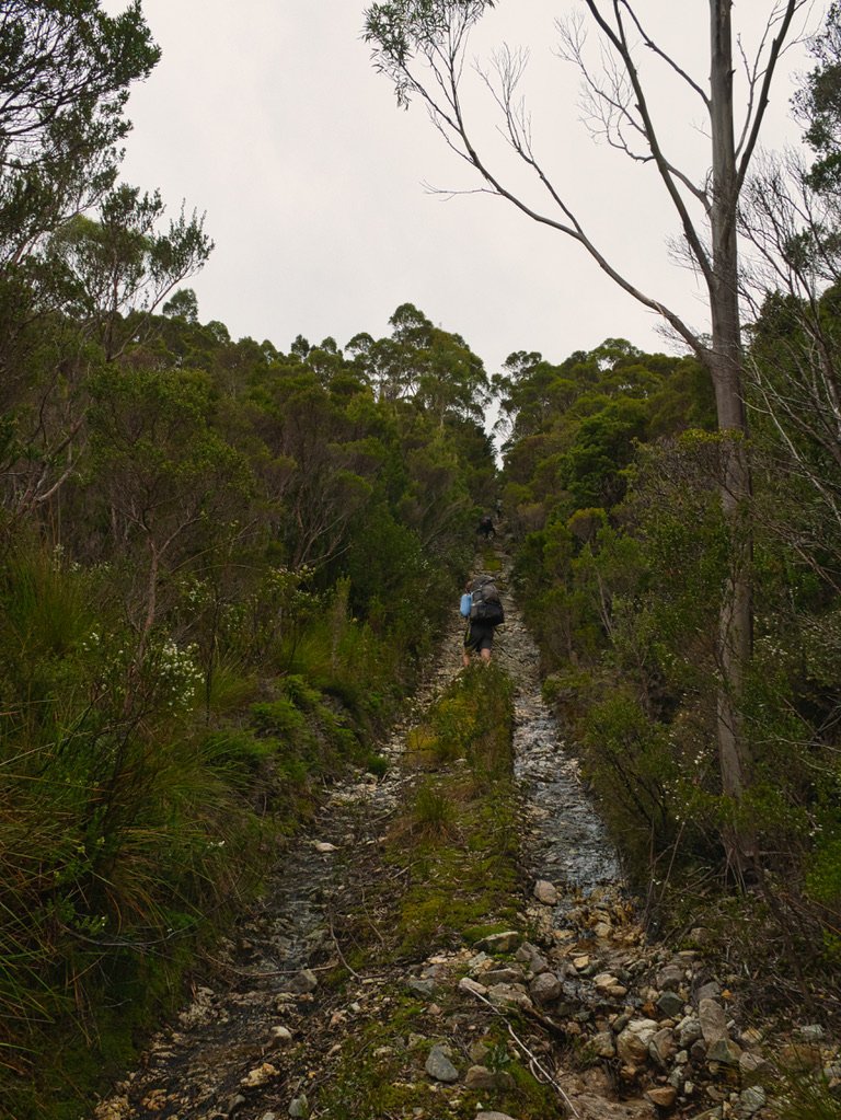
Leaving the bauera and button grass behind, we followed the pad downwards through rainforest, crossing two small, barely flowing creek beds. We were dropping elevation quickly, only to level out briefly then climb again. The rainforest before the Clark River was steep and very slippery. I was glad we weren’t carrying our big packs down here! Apparently there is camping down near the Clark River, but I couldn’t see anywhere convenient to pitch a tent on this trip nor my previous one.

Dark myrtle forest as the Clark River comes into view.
Two lovely Huon Pines and a newly-flowering Waratah marked the spot where we crossed the Clark River. We were not sure what if any water would be available up on the mountain itself, so we loaded up extra bottles just in case. As it turned out there, were lovely flowing trickles near the summit, but later in summer we suspect these would be dry.

Clark River.

Reacquiring the trail on the western side of the Clark River.
The climb up and out of the Clark River stayed true to the pattern of the day: steep and slippery, and reasonably well marked - until it wasn’t! It was somewhere around here that the bottom of Ben Y’s well-used day pack gave out! Ingeniously he simply turned it upside down, refilled his gear and continued on! Smart thinking and the second MacGyver moment of our trip. And yet another reminder to check your gear before setting off!

Steep, scrubby walking up out the other side of the valley.

The trail was difficult to follow in open forest covered in fallen timber.

Breaking out of the forest and into the button grass. The occasional cairn appearing to confirm we were ‘on route’.

Picking our path towards the Mt Sorell ridgeline
The route to Mount Sorell is surprisingly well-marked, padded and shows evidence of having been cut once upon a time, but only in places and those places are totally random in nature! One minute you you’re following a distinct, obvious pad with tape in all the right places for easy navigation. The next minute it all disappears! This is particularly obvious after climbing up and out of the Clark River. The marking tape just stops and any pad that was once there is hidden by years of forest litter and infrequent visitation. However, we knew just sticking on a west bearing would would lead us out of the forest and to the open buttongrass along the foot of Mount Sorell.

Mist still stubbornly hanging around our mountain as we slowly get closer.

Determined but cautious faces - there’s still a long way to go!

The terrain becoming increasingly steep as we near the dense scrub towards the ridgeline.
This is where the real fun on Mount Sorell starts. From the forest edge until below its scrubby eastern flanks, there is no real pad. It became a choose-your-own-adventure type thing! Lucas and I would take turns leading through the low-to-mid-height vegetation, picking out the frequent pockets of rock and gravel for easier forward progress. Sometimes a chance cairn would appear and we would get excited only to realise it had no friends. Then later a tiny piece of once-pink, now-faded tape would flap on a shrub, but it too was alone in this world!

Gaining elevation over the button grass plain below.

Approaching the dense scrub.
We continued along in a now north-westerly fashion, aiming for the cut track I had found on my previous visit, higher up on the mountain’s flank. I cannot stress enough how important it is to find this track. Anything either side of it is nigh-on impenetrable!

Picking our way through the tight confines of the ‘track’.

Ribbons were in just enough places to keep us on route.

Dark and tight!

There were no lack of tall, slippery steps to haul ourselves up.
From the moment we had left the Clark River we had been climbing steadily. As we approached the foot of Mount Sorell, the route onwards became noticeably steeper. This steepness Lucas aptly described as a “wall” on our return journey. It feels sometimes like you are literally climbing a great, big, wall of slippery scrub as you ascend Mount Sorell.
I had dropped a waypoint on Gaia Maps on my last trip, and we were heading directly for it. Even with my waypoint though, it took a few minutes of hunting to find the first piece of tape that indicated we were officially on the cut track and that things were about to get real. This is where the character building starts! Once that tunnel sucks you in, you best be feeling committed. Sheer determination is what gets you through from here.

Lucas threads himself through the spindly mess of vegetation.

Skirting cutting grass on one side, solid rock on the other.

Traction up the increasingly steep slope was in short supply. The ground was slick from recent rains and potentially another walking group not that long ago.
Although navigation was easier now - losing the cut track in such dense vegetation is practically impossible - the upwards climb was relentless. Not just steep but tight too, grabbing whatever roots, trees and vegetation we could grasp to pull ourselves up through the tangle of flora holding us back. It is very reminiscent of Moss Ridge, but even more physical and much more claustrophobic. Jungle like. Slimy. Slippery. Enclosed. Tight. STEEP. Sheer hard physical work.
We weren’t even really bushwalking now, just clamouring, grabbing, reaching, grunting, swearing and dragging ourselves through tight gaps between Horizontal. This is hard stuff but my favourite sort of bushwalking due to the problem solving constantly on the go. Our pace had slowed a lot. Bender, Lucas and myself rotated being out front. Route finding was arduous; even though there was tape there were also lots of areas you had to search for signs of previous use before the next piece of tape would present itself.

Pretty wildflowers distracted us from the effort required to make our way up through the scrub.

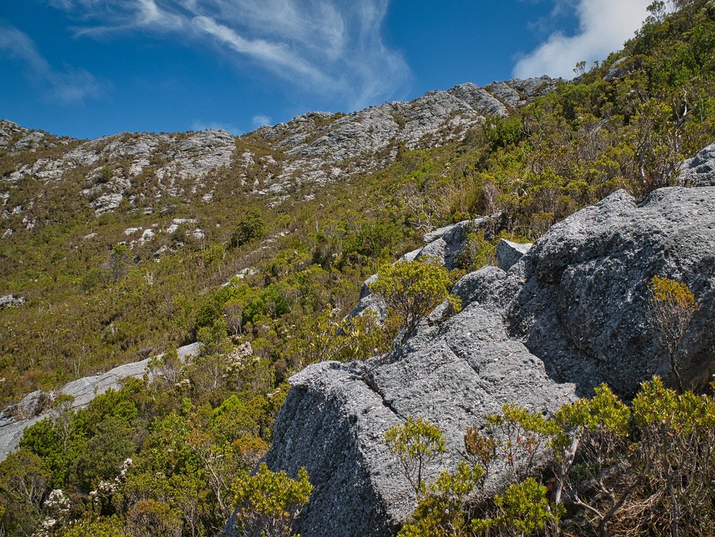
Breaking back out in to the less dense sub-alpine vegetation.

Long swathes of near-vertical conglomerate we’d have to climb up or around.
We eventually reached the section where I had turned back on my last trip because of snow. Here, the track cuts off abruptly at a sheer wall of rock. You have three choices. One to the direct left that involves stretching awkwardly from the track to a rock scramble using a sort of handy nearby tree. One to the right that leads to a scrubby dead end. The third choice is to go straight up the wall of rock in front of you, using the scrub bordering its left hand side.

Josiah contemplates his next move in Mt Sorell Chess.
Bender and I scrambled up the wall of rock in front of us but it was hard, slightly precarious work and then there was a 1.5m drop on the other side. We yelled down to the others to try to take the rock and the tree to their left. Lucas and Josiah made it up, but Ben Y was starting to feel a bit drained at this stage.
It’s hard to appreciate just how steep this part of the climb was.
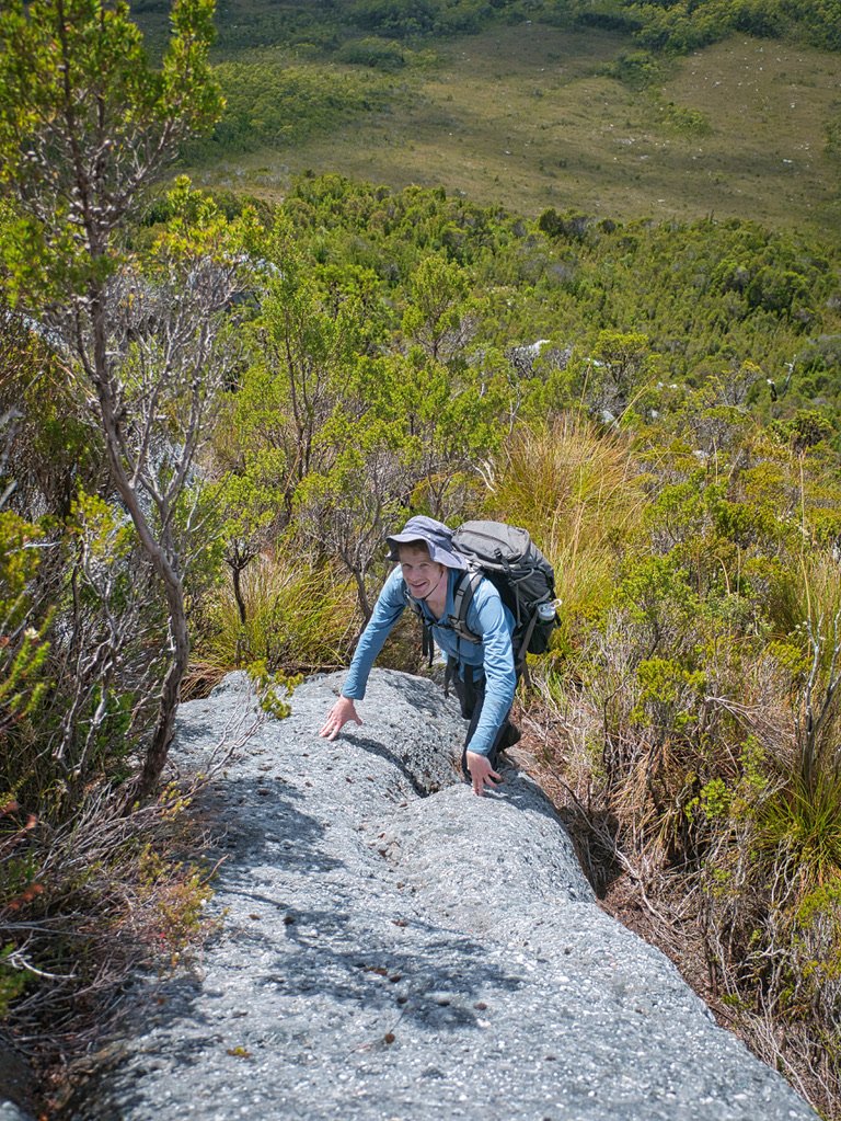
Lucas chuffed to be out of the scrub and onto rock for a moment.
The pad and marking tape yet again became very sporadic, and we were using a lot of energy navigating. More sections of vertical rock to climb, more sections of energy-sapping scrub to pull ourselves up or slide down with care became the norm. The contours on our maps were showing us what we already knew - we were in the thick of very steep terrain and we were moving too slow to make the summit in safe time to get back before dark. Every single time we would crest a small high point expecting a reprieve, we would be disappointed.

Still climbing… surely the mountain has to stop at some point?!

Catching a breath while the sun now beats down on us. Still smiling (and squinting in the sun!).
Often the rock was more awkward than helpful, but it was the lesser evil than the dense scrub that bordered it. The day was heating up and the hours were ticking over faster than we were moving. It had been five hours so far and we were only two-thirds of the way to reaching the summit. And we still had to get back to camp too.

Using the slabs of rock to our advantage.

Yep, it’s a long way down. Our camp is nestled behind the bare patch of rock towards the upper-right.
We sat and looked at yet another wall of rock and scrub rising above between us and the summit ridgeline. Ben Y bravely and wisely made the call to call it a day for himself. It was heartbreaking for all of us, as we understood what a difficult decision it was for him, especially after all the effort and sweat to get this far. It was very generous of him too as he recognised that Bender, Lucas, Josiah and I could move forward quicker without him and he gave up his chance of a summit for us. We left him lunching and enjoying the magnificent views on the rocky outcrop, but not one of us didn’t feel sad about it. He would make his way down after resting for a bit and was equipped with all the right safety and navigational gear, not to mention experience, to make his way back to camp.

Ben Y enjoys a well-earned break before heading back to camp. Quite the spot for lunch.

Lucas and Josiah catching their breath as well steel ourselves for the final push to the top of the ridge.
More straightforward climbing from here on in, but still very steep.
We had to move quicker now and respecting Ben Y’s sacrifice, move quicker we did. Well, as fast as you can when you are going almost vertically straight up. We were all very conscious that if we wanted to reach the summit and return back to camp before nightfall, we had to cover some serious ground pronto. Up and up we climbed. Like Jack and The Bean Stalk. Our legs and arms were tiring from constantly hauling our body weight upwards.
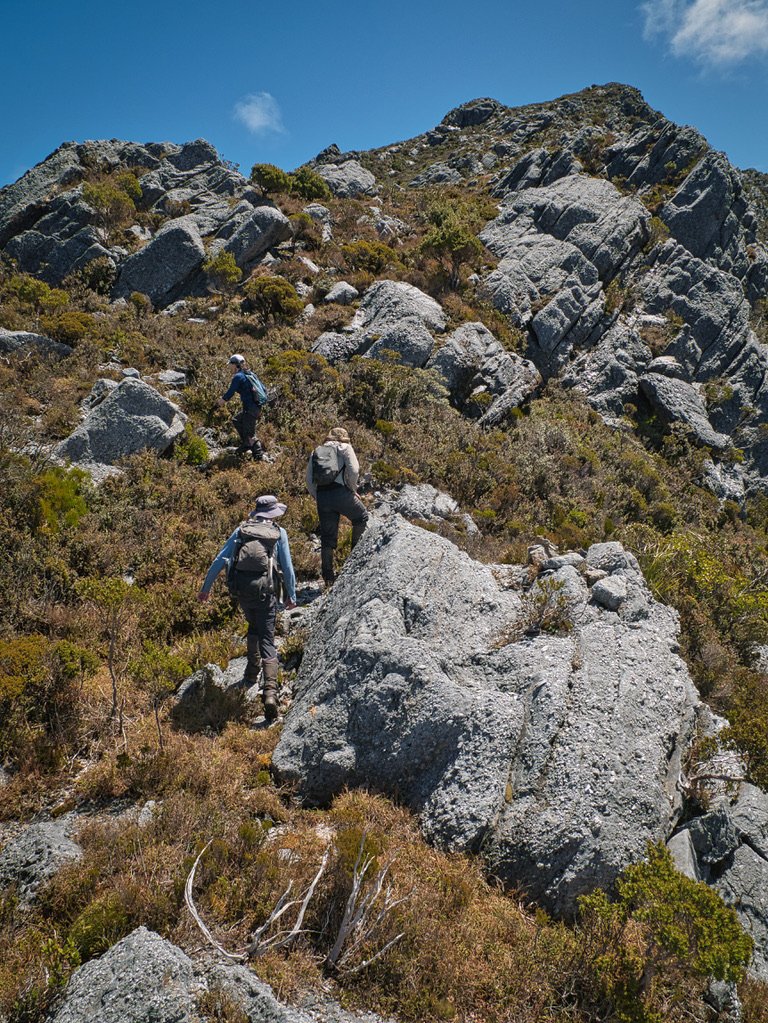
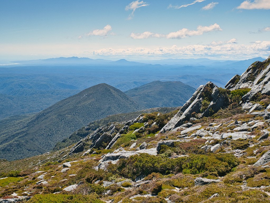
As we approached the ridgeline Lucas stumbled on a whole series of cairns. There is much delight in finding random evidence that others too have been here, and getting that validation you are heading in the right direction. Cresting the wall of rock and scrub we finally broached the main ridge and were treated with views of Macquarie Harbour for the first time, gloriously blue with the sun high in the sky. But we were also greeted by yet another steep climb between us and the summit further north. There would be multiple stings in the tail from here until the top - no flat plateau walking here!

Finally cresting the top of the ridgeline.

Looking south towards Macquarie Harbour and the Kelly Basin.
The one thing we did have for the first time though, were lovely open views of the way forward. Yes, were were still climbing and climbing steeply, but at least the vegetation was low and there were enough pockets of rock and gravel that the walking was actually walking and not climbing through scrub. Lucas’ long legs set a good pace and my short legs did the best to keep up! There were at least three more high points to go up and over, and a couple more we could sidle around to the west, but finally - FINALLY - we could make out the ageing summit trig in the distance!
More climbing!

Finally we can see the summit!

Looking south west over Macquarie Harbour and the Indian Ocean.

Sidling the western side of the ridgeline.

One more climb.

Making the most of the small stream just south of the summit.
Even better, useable trickles of cool, fresh water were flowing around the plateau just below the summit. Filling our cups and bottles we drank greedily, before our heavy legs crossed the final few hundred metres to the trig. It was done. We had made it. It had taken six whole hours of consistent walking, grunting and climbing but now we were four of the luckiest people in the world.

Working our way up and around the stream towards the summit trig.

One very happy Mr Chamberlain!
The ocean and harbour below us, mountains rising in just about every direction and the sun on our backs. You cannot put a price on that. Nor could you wipe the smiles off our sweaty sunscreen-covered faces. Well, until we looked across and saw what appeared to be a random rock or a cairn on another high point just to our north?! Surely not!

Enjoying a late lunch at the summit in very pleasant conditions.

Looking north-north east: the northern high point of Sorell, Mt Sedgwick, Mt Jukes and Mt Darwin.

Looking south over the Mt Sorell ridgeline. Macquarie Harbour and the lower peaks of the coastal south-west. The faint outlines of Mt Robert, Mt Sprent and Mt Lewis can be made out (just).
All of us looked warily over to the next high point. It would only be 10-15 mins - ok, maybe 20 - to get there, but was it the high point or were we already on it? Our GPS maps had varying answers. We had had a limited amount of phone reception so we checked our two Bushwalking Bibles - these ladies never get it wrong - RockMonkey Adventures and Nature Lovers Walks. They too had the ‘true summit’ as the Trig. Bender was still unsure, and none too keen to leave without making sure we had the true high point, so we made a quick call to Mr Bill Wilkinson himself of The Abels no less! Damn, no answer! But then my shattered brain remembered that I always carry photos of each Abels essay for reference.
I handed the essay to Bender, who was delighted to read the high points are actually twins, both of 1144m ASL. Yay - the Trig it is! Once we were all satisfied that that Mount Sorell could be truly considered climbed, we ate our lunch, chatted about the views and removed a goodly amount of leeches from our legs. All four of us had blood on us or our clothing from the hungry fellas!
Since returning from the trip, we can confirm that Mr Bill Wilkinson considers the Trig as the high point by at least 1mm even though the twin high points are marked as 1144m (perhaps he was joking, but I will take it!)
Looking north-west: Mt Heemskirk, Mt Strahan, Mt Hadmar, Mt Dundas and Mt Read.

Looking east across the Mt Darwin ridgeline, Mt Gell, Frenchmans Cap and Clytemnestra dominate the horizon.
All too soon the time to descend arrived. None of us wanted to leave the mountain - mostly because you could not get a better day for being atop a west coast summit. But also because we all knew the work ahead to get home to camp.

One last look at the southern end of Macquarie Harbour before we drop off the eastern flank of the ridgeline.
Chatting, wandering and checking our navigation where necessary we arrived back at the edge of the ridge where we had left Ben Y almost three hours earlier. As expected, he was no longer there, having set off for camp half hour after we farewelled him. We were all tired at this stage and none of us were what you could call enthusiastic about leading, but we took it in turns picking the route back down off the mountain.

Southern spine of Mt Sorell.

Camp is so close, yet still so far! The exploratory tracks south of Mt Darwin can be easily seen on the neighbouring ridgeline.
Mount Sorell takes almost as much vigour to descend as it does to climb. In fact, we found that the navigation was often harder on our return journey. Even though we had three different GPS devices recording our tracks from the climb up, there was still a lot of route finding, reviewing photos taken on the way up and guesswork involved. Moving so slowly on steep and often densely covered terrain resulted in our GPS routes looking like Mr Squiggle had had an epileptic fit on the screen! We would reach a steep rock outcrop, immediately think “no way did we come up that!” only to later realise that yep, we did! After a lot of second-guessing we eventually made it back to the “cut” track with only one real navigational error: thanks to Lucas recognising a rock feature above us we were able to double-back before getting ourselves into a potentially bad spot.

Dropping down on off the ridgeline. Surprisingly the initial descent was as involved and technical (and slow going) as the climb a few hours earlier.

Dropping into the thicker scrub part way down.

Dropping back into the ‘green tunnel’ was a relief, both in terms of navigation as well as hiding from the afternoon sun.
Collective sighs of relief sounded all round when we reached the forest track that tunnels down towards the buttongrass above Clark River. It had been steep on the way up and was even steeper to descend! Bum sliding, hanging onto scrub to lower ourselves down or just tripping and falling became the order of the day. Crossing the buttongrass quickly, we were all eager to get back to the Clark River and the final climb back up to camp.

Descending back down through the buttongrass and lower scrub towards the Clark River.

Mt Darwin Range.
What had been a steep descent to the Clark River on our walk in was now an unceasingly upwards challenge for very weary legs. We used the vegetation changes and landmarks to tick off the kilometres back to camp. Clark River - check. Hard to navigate forest after Clark River - check. Steep climb out of the forest - check. Drop down to dry creek - check. Buttongrass and find the taped track - check. The final obstacle was the climb back up to the road. Up ahead we could see Ben Y making his way to the road. We would all finish this together.
As the gravel crunched under our feet indicating the final few hundred metres to camp, the five of us exchanged war stories. None of us could be bothered with the additional five minute trek to get extra water, so all just made do with what we had. You know it has been a tough day at the office when an extra 10 minutes is considered too much.

Re-crossing the Clark River after a short, much needed break.

Golden hour light across the south west.
It had been 11 hours and twenty minutes of straight up hard work climbing Mount Sorell, but as the sun set and lit her great walls of rock and scrub pink and orange in a serene, windless evening, it was somehow all worth it.

Our camp disappears from the evening light.

Three wise men discuss the trials and tribulations of a tough day in Tasmania’s wilderness, while the sun excuses itself and goes to bed.
As we finished the road walk the next morning we spied a random esky just sitting near our cars! I was leading but made Bender go in front just in case there was a murderer hiding in the bushes - you never know! What a lovely surprise to find the esky was actually dropped off by our friend Brian (who isn’t a murderer!) and contained very much appreciated chocolate and cold drinks. It was time to get changed, head to the nearest café and enjoy a meal and drinks with our walking buddies. Life is good indeed.
The walk back to the cars begins with the extremely steep (and quite slippery) track straight up to the ridge.

Drizzle bearing down on us fast from the north.

Cold drinks and tasty treats are always appreciated (thanks Brian!).

Post walk - Bruised and battered but full of good food and mountain climbing goodness! (Thanks Ben Y for the pic!)
The Stats.
Distance: Approximately 6km and 500m of elevation gain on the road walk to the spot we camped. Approximately 11.5km return to the summit with over 1300m elevation gain!
Time taken: 11.5 hours return to camp.
Difficulty: Very difficult. It should only be attempted by experienced walkers competent in off track walking and navigation. Not one we recommend you do solo!
Type of track: Untracked but sporadic pads, cairns and tape to the summit.
Access from: Kelly Basin Road.

The Map.
Route taken to Mount Sorell from camp.