Snowy South
Date: 13th June 2020 – Summit: 1398m

Lake Skinner on the way to Snowy South.
With shorter winter daylight hours and only multi-day Abels left for us in the north of Tasmania, our adventures now tend to take us southwards. But like most people, we have children, jobs and other commitments, which mean extra time driving, camping and hiking is very precious and often limited. A day hike in the south is an overnight trip from the north. We chose Snowy South for no other reason than it appeared more than doable on a winter's day even if the weather forecast wasn't ideal. Our glutton-for-punishment personalities also had us considering a traverse from Snowy South to Nevada Peak if weather and daylight allowed for it.

Gearing up in the pre-dawn darkness.
In the back of our minds we wanted not only to climb Snowy South, but also Nevada Peak which lies to its north. A big call given the limited daylight hours available to us. Nevertheless, we mapped out our route from Snowy South to Nevada Peak in advance and discussed the ridiculously early start needed on track, if we were even in for a slim chance of summiting both. The weather forecast was for cold but dry weather, maybe a little snow at the summits. Given how early we wanted to start on track it made sense to travel down the night before and sleep in the Mazda at the trail head. Leaving Launceston around 6pm had us pulling in at the Lake Skinner Walking Track carpark at around 10:30pm that night. During the final part of the drive the fog had been so thick the car was crawling along but we had been treated to a beautiful Spotted Quoll meandering along. Somewhat disappointingly it was also drizzling. Our original on track start time of around 5am was already being revised.

The sign at the beginning of the track.

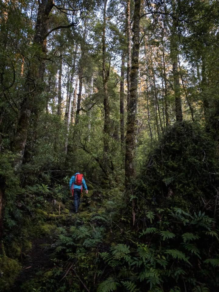
Our head torches illuminating the track.

The track distinct even by head torch.
A combination of a late bed time and listening to rain pour down all night had our dreams of getting an early enough start and good enough weather to summit both Snowy South and Nevada Peak dismissed. Instead, we slept in a little and were geared up ready to go around 7:30am. Being a week off the winter solstice, it was still dark as we were setting off and the first half hour of walking was completed with our head torches. The track - although very boggy in places - was well defined and varied from soft padded forest floor, old board walk, boggy mud sections and rooted or rocky terrain. At all times dark from being under the dense forest canopy. Very little light was getting through.

Darkness making the going a little slower than normal.

Large, toppled tree mounds form a lovely sight along the way.

Debris over the track means some detours are necessary.

Old boardwalk assisting in crossing wet marsh areas.
The track was, for the most part very obvious, even in the relative darkness. In places, fallen logs meant short detours off the track were necessary before doubling back onto the track. The old board walk sections have definitely seen better days and I wondered why it seems very little maintenance has been done in the area. The boot washing station was working but there were no pencils or pens that worked with the log book, so we had no option but to not record our intentions. We have now decided to start carrying our own pencils for just such a situation. We saw many people along the track that day and none of them would have been able to sign in either. Perhaps the track is neglected as Parks don't realise how much use it gets? We were already wearing our wet weathers due to the rain that fell over night and I was glad as the bush does encroach on the track.

Reaching the more beautiful, untouched section of forest.

Pandanis, ferns and roots litter the track.
Magical shades of forest green lead you up.

The climb gradual and undulating.
Leaving the initial regrowth forest behind us, we reached the untouched forest. Every shade of green beauty surrounded us, as did all textures. Soft moss underfoot one minute, rooted or rocky the next. Pandanis, ferns, myrtle, sassafras, eucalypts, cutting grass, lichens all in abundance. Almost no light shone through the canopy even though it was well and truly daylight by now. The forest definitely had an enchanted feel about it. The elevation rose gradually but consistently with just the very occasional steep pinch to remind us we were gaining height.

Climbing over debris on the track.

Recent rains turning some sections of the track into mini waterfalls.

A combination of use and rains causing boggy sections.

Ribbons mark the track although it really doesn't need them!
Continuing upwards finally some light was starting to make its way though the trees above us as the forest became more open. We knew that we would reach slightly more exposed terrain before at first descending and then climbing once more to Lake Skinner.

Skeletons of trees make for a ghostly sight.

Bender waiting for a "Xing falls in" moment.

Happy to have even a flooded track leading through the dense bush.

No mean feat cutting a track through rock like this.
Upwards before the downwards!
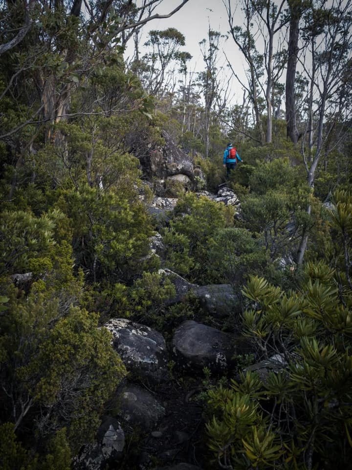
It was pleasant to break out of the forest canopy into the more open terrain even if it meant we were subjected to the chill of the wind for the first time. Here, the track began to climb a little more whilst also sidling around towards the northern end of the lake. We would keep climbing through the much thicker scrub for a few minutes before descending steeply.

Beginning our descent before the climb back up to Lake Skinner.

Looking back down along the track just prior to Lake Skinner.
I am not a lover of hiking up, up and more up to then have to descend again! But we had no choice as the track dropped steeply down and lost some of the gained elevation before briefly levelling out and then once again climbing. We were glad that the track was cut for us as in some sections the scrub was quite dense and hid ankle-rolling rocks beneath it. The sun was shinning a little now and we were quietly disappointed that our lazy sleep in had cost us Nevada Peak. As it turned out, the weather would deteriorate and even if we had had the time, we would not have attempted it.

Lake Skinner.

Snowy South over that hill...

Evidence of a camp fire and no evidence of a log book.

Our crossing point for the outlet creek.
We attained Lake Skinner in well under 2 hours even with multiple stops for photos, videos and snacks. Here, we allowed ourselves the enjoyment of exploring the man made rock shelter and soaking in the impressive views around Lake Skinner. Clearly a popular spot with walkers, there was evidence of previous camp fires, which is disappointing, but I told myself perhaps it was a case of survival that they had been lit. It wasn't difficult to find an easy and safe place to cross the outlet creek using some old timber logs and perfectly situated rocks. Once across the creek, a faded ribbon confirmed we were on track to Snowy South.

The beginning of the climb up towards the plateau below the summit.

Glorious baby Pandanis that I fell in love with.

Lake Skinner below from half way up the ridge.

Nearing the top of the climb.

The gradient easing as we near the top.
Without delay after crossing the outlet creek the track began to climb steeply. This section of track was obviously less well travelled than its counterpart below the lake, but was still easy to follow and marked reasonably frequently with both ruben tape and cairns. It climbed steeply, but within that steep climb there were additional small sections of very steep climbing over rocks or through scrub. This was the first time during the whole day thus far that I had felt the 'mountain' in the mountain, and our pace had slowed to allow for the climb but also to stop and soak in the views opening behind us.

The final push to the initial rocky plateau.

The narrow but obvious track leading up.

The rocky terrain leading to the collapsed gully that needs to be negotiated.
When previously standing at the lakes edge I had looked up the ridge that we would be climbing and determined that although quite steep, the angle would lessen three quarters of the way up and that after that it would be a small climb to the plateau before the summit (note the summit isn't visible from the lake). I was correct in my assumption and after climbing steeply the gradient reduced for the final 50m of so to the boulder field that allowed us the first glimpse of the days target.

The boulder field ahead that surrounds the summit.

Looking across to Nevada Peak (not in picture) wishing for a long summer day so we could go there too.

Small creeks and mini tarns across the plateau.
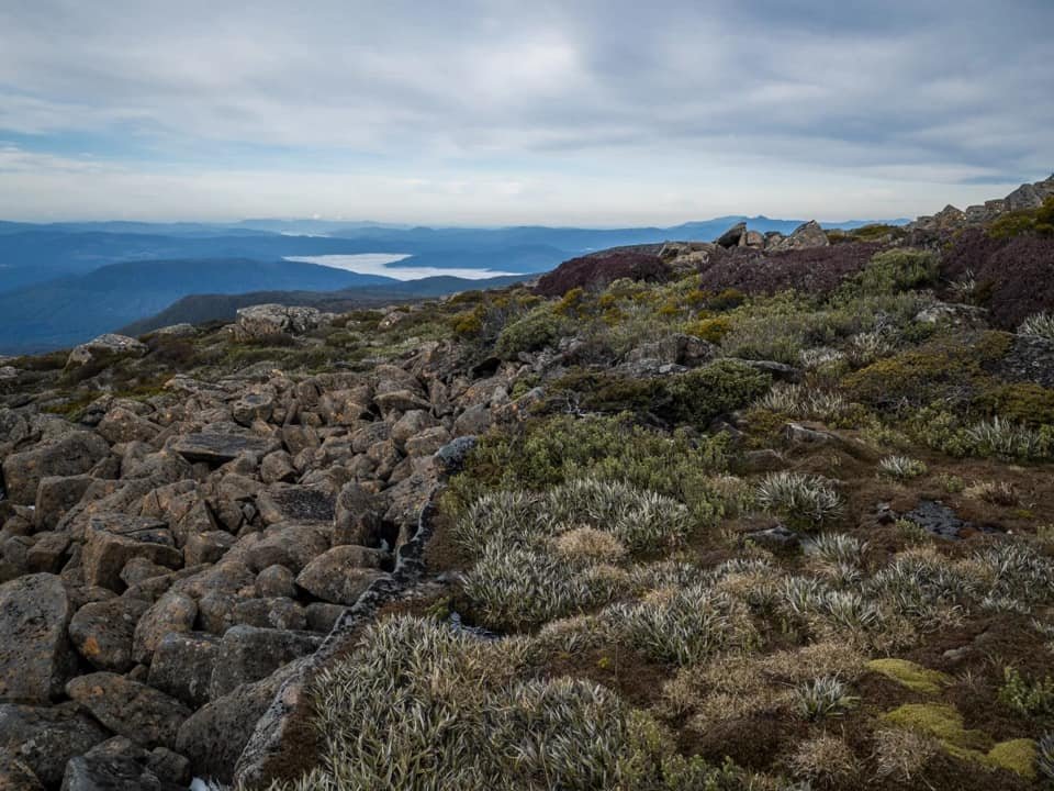
Reaching the rocky, open area at the top of the ridge allowed for clear views of the summit, but also no shelter from the strong winds and cold temperatures. The miniature creeks and streams were frozen over for the most part, but access to water was still plentiful. We continued to head to the collapsed gully that lies on the journey to the summit whilst discussing our route to the summit cairn. The Abels recommends continuing across the large boulder field below the peak in a westwards direction until making the final approach from the north. It also mentions that a large unnamed tarn could be used as a navigational aid on the return.

Looking back down towards the unnamed tarn from half way up the boulder field.

Following the cairns through the boulder field initially.

Navigating the slippery boulders.
Whilst the "track" from this point onwards wasn't formal it was obvious. Occasional cairns assisted in bringing us closer to the summit. The cairns were also leading across the boulder field in a westwards direction. Great. What wasn't great by now were the howling winds and it was freezing. The awkward and frankly huge boulders were covered in visible layers of ice. The thickness of the ice covering them and nestled between them increased as we climbed.

Some large, awkward and ice covered boulders making the going slow.
Leaving the boulder field for more easier walking in the alpine vegetation.
I was eager to get off the boulders and to the summit and then hightail it out of there before Mother Nature showed us what she was really capable of. But my eagerness was tempered by my equal inclination to stay safe. That meant a painfully slow boulder hopping/climbing/crawling pace. At one stage, Ben stopped to put his GoPro on to film the final few hundred metres of ascent, as stopping for photos and video in those conditions was far from ideal. I had continued on and then looked behind me to see nothing but ice and rock, screaming winds and no Ben. Yelling into the wind was useless. I considered getting my whistle out but I didn't think my fingers could be that dexterous. Instead I waited for what seemed like an eternity before his head popped up behind some large boulders.
I decided I had had enough of awkward, icy, break-my-leg boulders and changed direction away from the cairns to small patches of scrub hiding in amongst the boulders. Very happily I continued on using my new friend Astelia alpina - aka. Pineapple grass - to safely deposit me just under the summit outcrop.

First attempting to reach the summit via the large boulders below it - only to give up!

Approaching the summit from the scrub behind it.
Looking up at the giant boulders above me covered in thick white ice I decided that the summit wasn't worth it if that was the only way up. Behind the summit though lay some more of my friend the pineapple grass, and we were able to gain access to the summit cairn by following the vegetation to just below the back of the summit and then scrambling a few Tracey-sized rocks. Yay for the summit!

Final push to the summit.

Western views from the summit to Mt. Sarah Jane, Mt. Anne and Mt. Wedge.
I left Ben at the summit and dropped down behind some boulders to try to shelter from the winds, whilst he took photos of the misty abyss. I did love that it was snowing lightly though. Whilst waiting for Ben, I decided there was no way I was returning via the "break-your-leg" icy boulders. Cairns or no cairns. I would instead use every bit of greenery I could find to lead me down off the boulder field and to the unnamed tarn at the base and then rejoin our original route further along.
Even in the terrible weather I was enjoying the views towards Mount Anne and Mount Sarah Jane, the Western Arthurs, Federation Peak and many more glorious mountains!
Secretly Ben would have preferred the boulders and the known route, but he could tell he would have to piggy back me if we were to return that way! Taking a compass bearing of the unnamed tarn in case it disappeared from sight I set off. The return journey using low lying alpine scrub and pineapple grass was not only easier and safer than rock hopping icy boulders, but it was far quicker and much more sheltered. If I ever climb Snowy South again I think I would completely ignore the large boulder field (even in fine weather) and just scoot up the vegetated and easily navigated green belt that connects the summit to the unnamed tarn.

Ignoring the cairned route along the boulders (note the cairn on top of the boulders left of me) and instead choosing a much easier descent via vegetation.

My friendly pineapple grass patches keeping me off the awkward and icy boulders.
Speeding down our pineapple grass and low alpine vegetation slope we arrived at the unnamed tarn and shortly after were back on our original route with not a boulder to hop! The steep descent from the sub-alpine realm back down to the edge of Lake Skinner was almost harder on the way down than the way up, but at least we were once again out of the elements.
Hearing voices whilst crossing the outlet creek back to the track at Lake Skinner we found a family enjoying a picnic and kids swimming in the freezing water. I did not envy them at all I must say! We would pass at least another 8 people in varying groups heading in to enjoy the lake. None were proceeding on to Snowy South. Perhaps one day when we have climbed all the mountains in Tasmania we too will leisurely wander into lakes for picnics and swimming and look up at mountains and think what sort of mad people want to climb up there.
The stats.
Distance: Approximately 14km out-and-back
Time taken: About 7 hrs, including numerous stops.
Difficulty: Easy to Moderate.
Type of track: Well tracked and marked to Lake Skinner, then a good pad and occasional tape and cairn to the summit.
Access from: Access off McDougalls Road and the Lake Skinner Walking Track.

Route taken to Snowy South.