Western Arthurs Day 4
Day 4
21st January 2021
Square Lake to High Moor
Additional climbs - Mt Sirius, Mt Orion, Mt Pegasus

Did we really climb down that?! Photo Credit: With thanks to Grahame Kershaw
Day 4 of the traverse was always going to be our biggest day physically. We would be leaving Square Lake to make our way to High Moor camp, which is difficult enough, without adding in some extra climbs. It would be a long, hot 12-hour slog - for a measly 9km! Whilst we weren’t “rationing water” we were all conscious of its scarcity on this leg of the trip. Thank goodness for Grahame and his collapsible cup, which allowed us to seek precious hydration from tiny trickles along the way. From storms and freezing temperatures on Day 1 to burning hot sun on Day 4 - The Western Arthurs really was giving us a taste of everything.
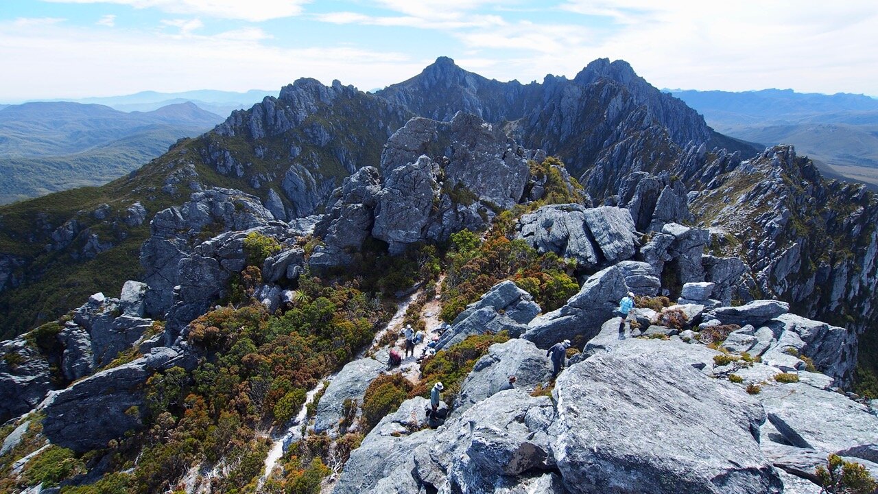
Photo Credit: With thanks to Simon Kendrick
Why not watch & read?
Please enjoy a visual trip to The Western Arthurs in addition to the blog below. Whilst the blog gives you greater detail on the trip (including route information) the video allows those that may never reach its summit a virtual experience.
The team was planning on heading off around 7am in the morning, as we knew we had a long day ahead of us. We wanted to beat some of the day's heat, but also didn’t want to run out of daylight hours as we were attempting to climb a number of peaks on the way to High Moor.
The track out of Square Lake briefly dips into dense scrub to cross its outflow creek, before shooting straight up towards the next saddle. I set off early because I’m slower uphill than the others, but also because I wanted to try to get some almost-sunrise photos of Lake Oberon. Turns out I made the same time up that the team did and needn't have worried, but it was worth it for the spectacular colours over Lake Oberon, as I stepped onto the saddle between it and Square Lake.
Cresting the top of the climb, I dumped my big pack and raced excitedly across the small saddle to where I could fill my greedy eyes with views of a warmly backlit Lake Oberon. None of the pictures I have ever seen have done it justice. All the hard work of the previous few days melted away, as I sat gazing at its beauty whilst enjoying a fine breakfast of vanilla yogurt and finger lime granola. Alas by the time the others arrived the sun had risen beyond its early morning glow. It was hard to tear ourselves away from such a fine view, but Mt Sirius was calling!
The one good photo I took the whole trip! - Xing
Mt. Sirius - the knocker of knees!
Side trip Details: Under 30 minutes return from the main track. Extra 125m elevation gain. Occasional faint pad and occasional cairn to the summit.
The sun had set over Mt. Sirius the night before, putting on a lovely light show which we enjoyed from our tent at Square Lake. From camp, Mt. Sirius appeared both close in distance and easily summitted - I am glad to say it is both.
The main Western Arthurs track heads north-east after the climb out from Square Lake. Leaving our packs on the main track we sidled around a rocky knoll and headed south. The small rocky knoll has a few cairns leading up onto it and a faint pad leading around it - take the pad as there is no need to climb it to just climb down the other side!
Simon led us along the pad winding through very low-level alpine scrub and rock. The lumpy summit outcrop was visible ahead and so it was just a matter of heading in its general direction, along its north-western side. Occasionally a cairn would indicate the way but they were quite unnecessary.
A small climb is necessary to reach the summit - firstly through minor scrub with a solid pad and then over a few metres of boulders. All very simple and quick, indeed we were enjoying the summit views less than 30 minutes after leaving the main track! What a splendid way to start the day. The views to Lake Oberon below were magnificent but so too were the views to our southwest towards the plains and crossing river.

Photo Credit: With thanks to Grahame Kershaw and Simon Kendrick.
As much as we could have spent a very relaxing day up there admiring the sights, we had a big day ahead and needed to make haste towards Mt. Orion, picking up our large packs along the way. So fine were the views that I was more than a little distracted on the return journey to the packs, and I managed to roll my ankle on a small rock and land awkwardly with my knee giving off a disturbing cracking noise.
F#$k it! Hobbling back to the packs, I was cursing my stupidity and at the same time, hoping that the pain developing in my knee would pass shortly. The Western Arthurs is not a place to be with dodgy knees! (As it turns out the pain would not disappear but was numbed by copious amounts of Nurofen for the next few days - as well as Grahame’s expert massages and tips!)
Mt Orion - Here We Come!
Side Trip Details - Mt Orion: Less than 30 mins, well-padded and cairned route. Some scrambling over rock.
Hoisting our multi-day packs back on we continued along the Western Arthurs track heading in a northeasterly direction, initially losing a small amount of elevation before climbing into the saddle between Mt. Sirius and Mt. Orion. None of us were too sure where we would start our ascent, but as it turns out the exact location to leave the main track was obvious - a cairn marked the step-off point, with a very visible pad leading north up the south face of Mt. Orion.
Choices, choices...!
Reaching the small plateau area holding Mt. Orion's two high points took no time at all. Grahame and I reached the area first along with Jess and followed the very well established pad towards the initial (southeastern) high point. We were almost at the top when Simon asked where we were heading, as the true high point was the northern high point! It's a long way to come to touch the wrong cairn! Scrambling back down we joined the others below.
Another well-worn pad led us towards the correct high point through low alpine grass and some lovely cushion plants (stay on the pad!) which gave way to rock. Cairns were present initially but seemed to run out just below the summit outcrop. Some deft rock climbing moves however and we were up. Wow! For the second time today, we were being blessed with uninterrupted views of the Western Arthurs and beyond. One could spend a lifetime up there pondering the beauty but we needed to maintain our schedule to make camp before dark. Before leaving the summit, the others scouted around and found a far easier way to descend (Grahame, Jess and I went back the original way).
High Moor - the LONG, DRY journey.
The thing about the Western Arthurs is that nothing happens fast. When written on paper or measured on a map, the distances between camps are short. The reality is the opposite. The Western Arthurs are more climb, fall, trip, step, bum slide, climb, jolt down, climb down, climb up, trip and clamber... and then occasionally, just walk for a bit... then repeat! We would often joke on our journey when we were making progress faster than one kilometre per hour, that we were moving fast! High Moor day was always going to be a long day. Throw in some extra peaks, killer sun and temperatures, and a long day would become an arduous one.
Our first real Western Arthurs descent.
The day thus far had been relatively easy. A walkable track, short side trips and cool weather. Descending off Mt. Orion I could feel the heat of the day starting to build, and my dodgy knee was reminding me with the occasional sharp stabbing pain that I was careless on Mt. Sirius. After a quick snack and with our heavy packs firmly back in place, we began the very steep descent into Lake Oberon.
Quite often with bushwalking, you need to get yourself up and down steep hills. The Western Arthurs puts the steeeeeep in steep! Looking down the rocky passage that moonlights as a track down to Lake Oberon it seems as if there is no way one could get down it! Grahame and John were our intrepid leaders (or lab rats) for this descent. They would forward scout the descent and the look on their faces, how quickly they were moving, or the occasional curse word would indicate to us the level of complexity.
Slowly we picked our way down. At times climbing backward down rock, at other times bum sliding face first. All the time hanging onto a rock, a shrub, or a tree root to save a fall and loss of my front teeth! I remember thinking at the time - thank god we don’t have to climb up and out of here. Little did I know our forward journey would make this look like child’s play!
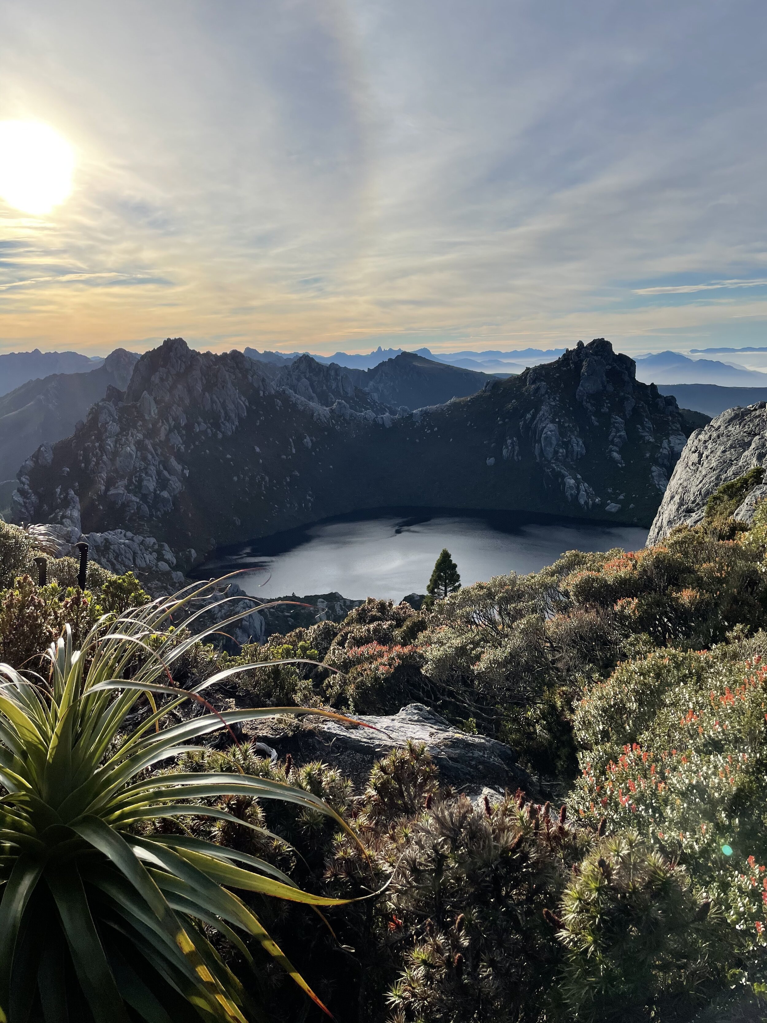
Dombrovskis' Jewel
Lake Oberon is as spectacular up close as it is from high up in the mountains. Peter Drombrovski’s famous photo of Lake Oberon certainly put the Western Arthurs on the map, and arguably the majority of people that visit this area go only as far as here, spending a day or two before heading back out Moraine A. Certainly this is recommended for less-than-experienced walkers, as the track past Lake Oberon becomes a very serious undertaking. I would like to head back in with friends someday soon and spend a few days just exploring the area surrounding Lake Oberon.
A short section of duckboard and stone path led our merry crew along the higher northern edges of the lake before we found ourselves climbing (again) out of the saddle and up towards Mt. Pegasus. The track would lead up and over a more minor knoll before descending briefly into the Pegasus saddle.
From here on in we alternated between climbing up rock or climbing up through vegetation as we pushed higher and higher. It was hot and hard work, and the fresh southerly breeze was suddenly nowhere to be felt! Breaking out of a band of scrub, the pad led Grahame around a small bend and to a sharp cliff! Ummm.. no way! There were even scratch marks where some poor souls have risked life and limb to get up the rock face. Luckily for us we scouted an alternate route, found a few cairns, and were shortly standing in the rock cave that allows passage onto the top of the range.
To rope or not to rope.
We had initially thought we would need to pack haul our packs up through the cave but instead we got them through by simply feeding them up via our human chain - one advantage to having a decent-sized group. A tip here is to make sure everything is strapped safely to your pack or inside it, as it is a very tight squeeze!
From the top we could see the rest of the day's journey ahead - it was a long way until camp. Time to break for lunch. Whilst I rested my knee the others quickly scrambled to the top of Mt. Pegasus (a few scrambled down just as quickly before the summit, as there is one horrid chockstone to negotiate!).
What goes up on the Western Arthurs must come down and as we were up it was time to go down! Using tree roots and vegetation to support ourselves we started the steep descent off Mt. Pegasus. Slow, slow, slow is better than fast, fall and fractured in my opinion. We were all super aware that a moment's mindlessness could quickly result in a seriously bad injury.
Not normally known for being a lover of heights, I was surprising myself with a newfound confidence in tackling climbs and exposure. That said, there were still some sections that made my palms sweat! Most of the more difficult sections would be much easier without a heavy pack on your back, swinging around like a pendulum, but that’s the joys of the Western Arthurs.
Up and down like yoyos we continued along. The heat of the day was making us all churn through our water rather more quickly than we had liked. I was very envious of Grahame's trick of catching little drops of water where it leeched off rocks with his collapsible cup, sipping away as he came across them. I made a mental note to put my camp cup in my zip pocket for the next day, and have since bought a soft collapsible cup for use on all my trips. It just makes so much more sense, especially when walking in summer.
I tried to remind myself to constantly stop and soak in the views, the smells and the surrounds. Such was the level of concentration needed that you could easily forget that all the hard work was a fair exchange for the feast your eyes and soul had. You cannot deny that the Western Arthurs are hard work. Every one of us struggled in some way, at some stage, over the entire trip, and acknowledging that is what makes us human and what makes the memories so good. But for now it was the heat affecting us all.
Having to ration water, not knowing when the next creek or tarn will be crossed, is never a lovely feeling! I was dreaming of getting to High Moor and dipping my sore knee into icy cold water for rehab... the others, slurping up their fill from the crystal clear water. That dream was shattered - more about that at camp!
Disbelief!
With the clock now well into the afternoon, plans to summit the now-quite distant looking Mt. Pegasus South were abandoned. We packed up our lunch and started the afternoon's “stroll”. One of the steepest descents yet had us bum sliding down towards Lake Uranus. Deep, dirt footholds somehow cut into the side of the mountain were our way down and in spots they would just give way below your feet. How on earth had someone cut them in there in the first place? How long would they last given the foot traffic and erosion?
Our pace was painfully slow but as we continued to learn with each step, that’s the Western Arthurs. Finally reaching the vegetated saddle at the northern end of Lake Uranus, we looked back, and each and every single one of us remarked “How the #$@! did we actually get down that?!?”.
Photo Credit: With thanks Jess McDonald
What a joyous surprise it was to see that the unmaintained track momentarily turned into a Yellow Brick Road - well, grey stone steps anyway! We could actually step, stride out and walk. Alas, it was very momentary treat for we soon hit scrub again and - you guessed it - started climbing again! This time the track jacked steeply up towards Mt. Capricorn. I was very glad it would be our last substantial climb for the day. There were yet more small pinches ahead, but that was the last substantial one on the route to High Moor.
Over Mt. Capricorn we went, all of us well and truly physically spent. With the last big climb of the day behind us it was just the lesser elevation gains to tackle, the scrub and awkward rock climbs. Even small challenges - when you are tired, heat affected, and probably a bit dehydrated - feel gargantuan. The last few kilometres felt gargantuan. I can't quite describe the sense of relief that seeing duckboard felt like. Soon, I said to myself, my knee would be in the icy waters of High Moor. We crested the final hill and saw camp... wait what? Where’s the water source? I knew there was no tarn or lake but thought it was perhaps too small to mention on maps.
You have got to be kidding?!
An extremely long and hot and thirsty day was coming to an end. But alas, other than one small sludge-filled puddle there is no water source at High Moor. No ice-cold water for washing sweat-soaked bodies in or for soothing sore knees. Barely drinkable sludge was all that was there. To make matters worse someone was washing their feet in the shallow, barely flowing water as we arrived. Insert crying emoji here. PWS has clearly spent money on camping platforms and a Sputnik toilet here but the water issue is still well an issue!
What High Moor lacks in water it makes up for in great platforms and views. With quite a few others on track, the platforms were fully packed with tents by the time we and a few others squeezed in. Painstakingly gathering water from the ahem, puddle I was glad I had packed water purification tablets. We never ever use them normally, as water is so rarely an issue where we hike, but I had packed them as a backup. I suspect the water indeed gave a few travellers an upset tummy, after talking to fellow walkers at Haven Lake the following day, that had developed gastro symptoms after High Moor. We were lucky, but did hand over some Imodium to a young bloke at Haven Lake who'd had a very bad day (his words!) getting there.
Tent pitched and dinner eaten, it was time to collapse for the night. Unfortunately, a restful night's sleep proved elusive as 60+ knot winds hit our exposed camp that night. Our tent was pitched such as it was taking the full brunt of it side-on; limited space on the platforms meant that we could not pitch into the wind. Extra guy lines secured our tent fine, but listening to the wind howl and feeling the tent sway and flap made for a long night indeed! The next day was Tilted Chasm and the infamous Beggary Bumps, so we were crossing our fingers the rain I could hear would disappear come morning!

Photo Credit: With thanks to Simon Kendrick
The stats.
Distance: Approximately 9.2km, including side trips to Mt. Sirius, Mt. Orion and Mt. Pegasus.
Time taken: Approximately 12 hours. Although the distance covered was short, the rugged terrain and endlessly sharp climbs (up and down) made for very slow going.
Difficulty: Difficult. We would gain about 1000m of elevation but lose nearly 900m too! This walk should only be undertaken by experienced hikers confident in negotiating varying degrees of exposure/heights, rough terrain and are in good physical shape to cope with such ground carrying a heavy pack. While the pad in this area is mostly obvious, it is unmarked and thus strong navigational skills are also a must.
Type of track: The section from Square Lake to Lake Oberon includes a series of very steep rocky descents. From Lake Oberon on, the difficulty of the route increases significantly. Warnings regarding turning back at Lake Oberon must be heeded, if bad weather is forecast or not fully prepared for 2-3 days of genuinely challenging bushwalking and climbing. An obvious pad leads through a combination of extremely steep ascents and descents over loose rocky terrain and/or through vegetation. There are sections where exposure to sharp drops may make it more difficult/intimidating for some walkers. We did not need to pack haul on this section, but on a few occasions did remove our packs and lower them down to a fellow walker.

Route taken from Square Lake to High Moor.