Cheyne Range
Date: 28th October 2023 - Summit: 1290m
Photo credits: Ben Wells, Tracey Orr

Descending to Lake Hermione.
Our grand plan for this long weekend were to summit both Mount Gell and the Cheyne Range High Point. What’s that saying - about best laid plans? Without giving too much away, I will say that, for me, Mount Gell is still elusive!

Mount Hugel from the Shadow Lake Track.
Bender and I had managed to score three days off and we thought what better way to spend it then to try to summit the Cheyne Range and Mount Gell. Bender had previously climbed Mount Gell via The Hippogriff with a mate, but hadn’t been able to reach the Cheyne Range on that occasion. A year on, still neither of us had climbed the Cheyne Range. In the weeks and days leading up to the trip we had been constantly watching the weather.
Just a few days before the planned trip, a Bushwalker’s Weather Alert was issued for snow down to 600m. Not unusual for springtime in Tassie but after such a warm winter and dry start to spring, the forecast seemed out of the blue. Still, the forecast was showing mighty fine weather to begin with, slowly degrading to cooler temperatures and potential drizzle over the next three days. Day 2 was to be our summit day, so we said “Let’s just go and see what happens”.
Our plan for Day 1 was to walk from Lake St Clair over the Mount Hugel plateau to Lake Hermione, or ideally a bit further west to the small tarn (which we’ll refer to as Franklin Tarn; apparently that’s what bushwalkers know it as though we’re yet to find a map with it named) and make a base camp for the next two nights. Then for Day 2 we planned on walking out to the Cheyne Range further west, and from there hop across the ridgeline south to Mount Gell, before retracing our route back to camp. Day 3 would then likely be a wet and slightly miserable walk out back to Lake St Clair.

Mount Hugel from the Shadow Lake Track.
Day 1 - Lake St Clair to Franklin Tarn.
We set off super-early from the carpark at the Derwent Bridge Hotel where we had car camped the night before, both of us impressed we were on the go by 7am. Ok, well, I was impressed that Bender was actually ready at our go time! However, that on-schedule glow was short-lived as we rounded a bend on Lake St Clair Road coming across a tree that had fallen overnight in the strong winds and was blocking our way forward! It would be at least an hour or so before anyone at Parks & Wildlife Service arrived, so Bender began the task of trying to shift it. We often take a cordless electric chainsaw with us just in case we come across fallen trees on forestry roads, but hadn’t packed it this time as we hadn’t expected to need it so close to a major highway. Thankfully he managed to break off and shift just enough of its straggly limbs out of the way that I could get the Mazda around it and we could get up the road to the Lake St Clair Visitor Centre carpark.
Excitement over and suitably parked, we booted up and signed in at the log book. The sun was already out - it was going to be a glorious day! We set off up the last stretch of the Overland Track, heading for the junction with the Shadow Lake Circuit Track at Watersmeet.
Our plan was to follow the Shadow Lake Circuit Track until the turn off to Forgotten Lake. We would then pass Forgotten Lake before heading up the Little Hugel Track. Sidling Little Hugel just before its summit climb, then continue across to the plateaus between Little Hugel and Mount Hugel. We’d visited Mount Hugel a few years before, so none of this would be new territory for us. I will begin this essay from the climb up Little Hugel - all the details to reaching this point can be found in the Mount Hugel trip report.
The one major difference between this trip and our last trip was that we were seeing early signs of snow on the ground! If there was snow this low down, what did the high reaches hold for us?!

Snow appearing on the Shadow Lake Track was a hint of what was to come!
The snow patches became larger and more frequent as we continued on, and by the time we reached the forest below Little Hugel the snow was getting quite deep on the ground. As we brushed past the trees, snow would fall on our heads. Our feet would slip into snowed over holes, and it should have been a warning for what was to come.

Glimpses of a properly snowy Mount Rufus hiding behind the trees as we turn onto the Forgotten Lake Track.
Reaching the boulders below Little Hugel, one could mistake it being the middle of winter instead of spring because of the amount of snow covering them! This was going to be a snowy trip apparently ;-) It was whilst climbing Little Hugel we ran into another couple who were attempting the full Cheyne-Gell Loop to Australia Tarn. They mentioned they were loving that we had made footprints in the snow on the boulders for them to follow. Stepping in someone else’s post-holes in the snow is much easier than post-holing yourself!

Snowy boulders on the climb up Little Hugel.
With snow covering the ground the usually distinct pad between Little Hugel and Mount Hugel was mostly hidden so we guessed our way along the route -post-holing in the scrub when we went off line - until we reached the spot on the upper plateau where we had selected our drop-off point. Looking ahead, we could see snow-covered peaks everywhere including Mount Gell and the Cheyne Range. Climbing both peaks was looking rather more involved than we’d been anticipating, but that was a problem for the next day. For now we had to concentrate on just reaching camp.

Leaving Little Hugel behind us as we approach the final small climb up and onto the higher Hugel plateau.

Looking back towards Little Hugel from up on the Hugel Plateau.
Most walkers heading into the Cheyne Range from this direction would follow The Abels recommendation to drop off the plateau more or less directly east of Lake Hermione. We had heard some horror stories about the scrub and the boulder fields using that route - and that was without the snowy conditions we had! We’d also heard of an alternate, apparently easier route that followed the ridge that leads north-west off the plateau that would land us a bit to the north-east of Lake Hermione.

Looking ahead to the plateau rocks. Somewhere up there we would begin our descent to Lake Hermione.

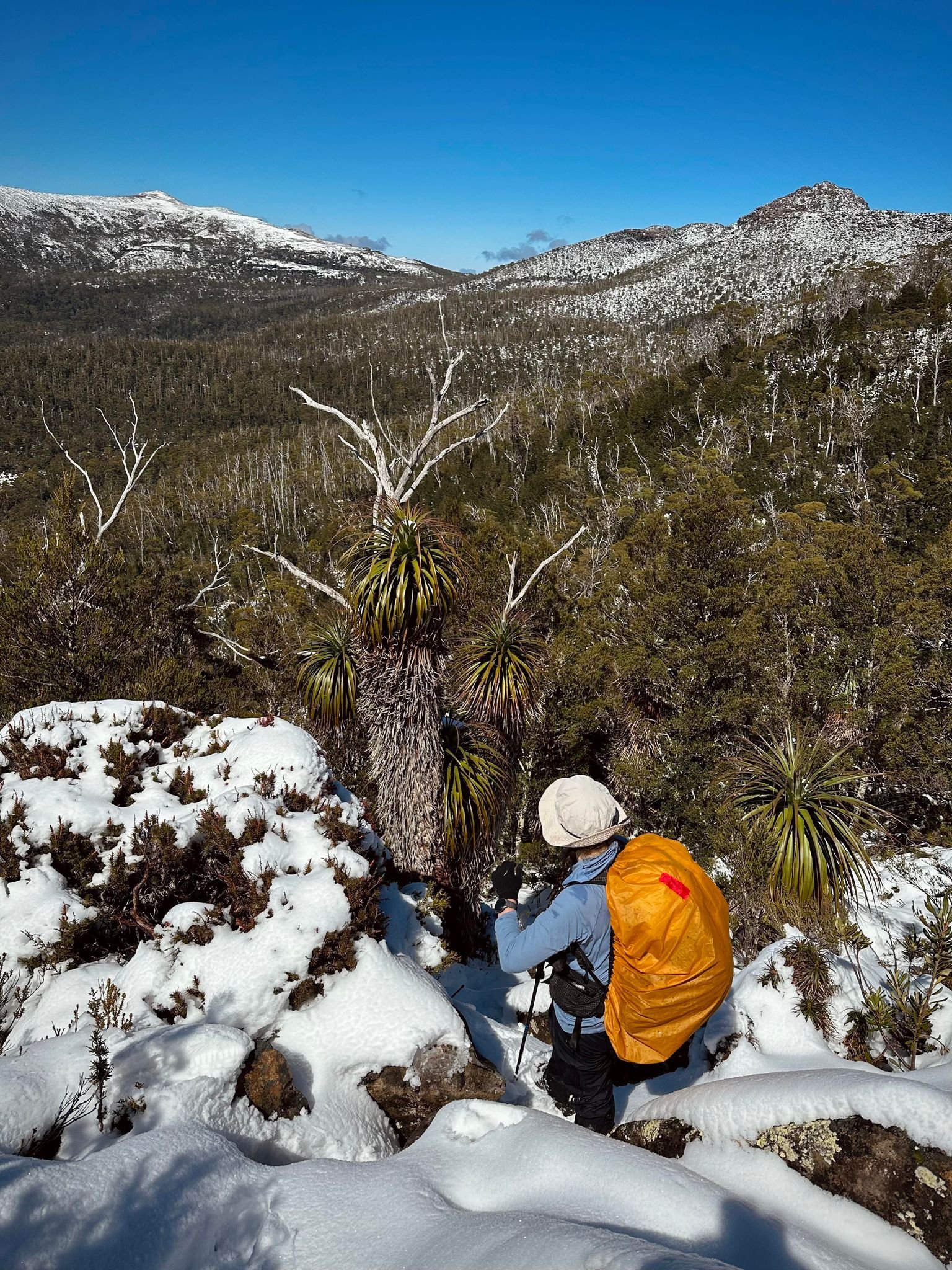
Starting our descent from the plateau. Mount Gell and the Cheyne Range in the far distance.
And it may well be, but it wasn’t for us! After a quick break on the plateau we began the descent down the boulders and snow-filled gullies between. Surprisingly, we stumbled upon some cairns! They were totally not expected but a very welcome surprise. But just as we got excited about them and the thought of a more formalised route, they disappeared. No problem we thought: we will just stick to our original plan of descending the ridge, picking the easiest path forward at any given time.
The thick snow cover was making everything hard work. When on rock, it made them slippery and covered the holes between them making every step a double step. The first step to kick our feet into the snow to see if there was a solid surface beneath it. Once we established it was solid, we could then step onto it. It was an annoyingly slow process.

The descent using the ridge heading north west off the plateau. We would not take this route on the return!
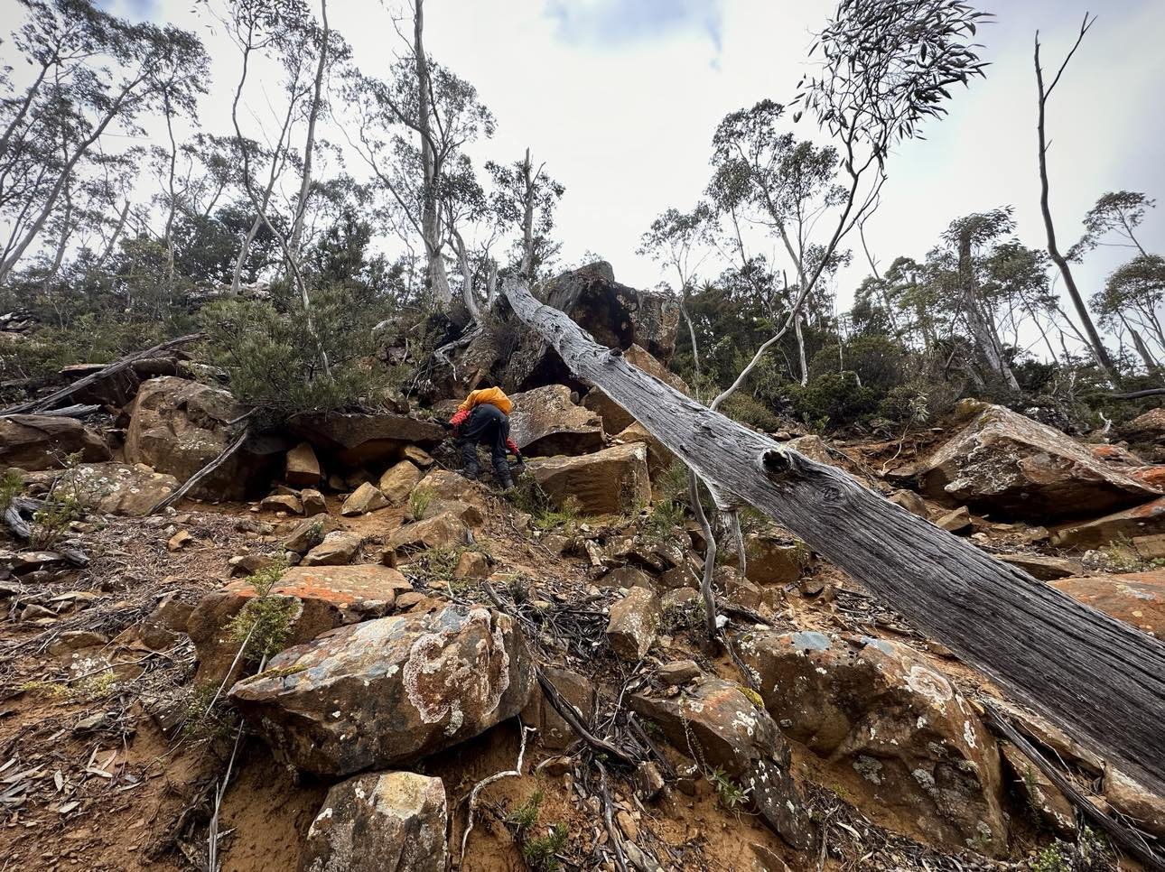
The scrub after the boulders wasn’t any better. With snow covering the undergrowth and fallen timber we would step and often then just sink, slip or trip. There was an awful lot of questioning our life choices going on! Still, we pressed on downwards only to be halted by a substantial cliff line. The cliffs were a surprise, and an unwelcome one at that, as on our maps they actually showed a minor plateau in the area - not a sudden drop!

The stunning colours on the trees were the only highlights of a very steep, very scrubby and cliffy descent!
As the cliffs were sheer and at least 8-10m high, there was no shimming down them. We have managed our way down some pretty sketchy stuff on previous trips in the area (Mount Gould and Sharlands Peak to name two) but with the snow covering a lot of the rock it was hard to see any safe way down. We had no choice but to sidle along until we found some kind of manageable gully.
Bender forward scouted north about 100m and eventually found a chink in the cliff’s armour. As we both made our way along the cliffline to the gully, I wondered if Penny & Mike (the couple we had met on Little Hugel) were still using our footprints. If so, they must have been thinking “where are these two going?!” The gully proved straightforward to descend despite being quite slippery, and finally we were back on our descent, now moving through forest.
Whether it was scrub or rock, the long ridge was tedious to descend in the conditions.

Using open forest to descend the ridge where possible.
Under the canopy of the dense forest we were shielded from the warm sun and my toes were definitely feeling the chill of walking in snow. I couldn’t wait to finally break out into the (still not visible) button grass fields below us.
This downwards section felt like pulling teeth. We were going down steeply but still seemed to make no progress at all. Some patches of forest were dense, some more open but all contained plenty of fallen timber, much of it hidden under snow, so the going was slow and laborious. Even the winter-wonderland type views were not weaving their magic anymore.

Finally off the cliffs and starting to bottom out.

Finally down off the ridge in the snow covered button grass and coral fern. At least here the snow was only patchy.
Finally, after what seemed to take far too long, we stepped out of the forest and onto the button grass and coral fern plain to the north-east of Lake Hermione. The going from here would be much easier. Firstly, we could see where we were going - which is always a bonus - but secondly it was flat and the mounds of button grass were a manageable size. Most exciting of all was that there was minimal snow for a bit!
Interestingly, while the button grass mounds were a manageable size, the clumps of coral fern were much bigger than I have ever seen. Big enough that it was easier to sort of step and hop from the top of one mound to the other, than to use the sometimes-deep trenches around them. We sort of walked, sort of mound hopped our way to the south-eastern side of the lake, as we knew we could easily cross the lake outlet there. The northern side was the inflow from the Franklin River and even from this distance we could see that it would be much wider and deeper to cross, and likely marshy either side.
Once across the overflowing outlet, we wandered the lake shore, following what animal pads we could. Half way around the lake we spotted a ripple in the water; I thought it was a fish, but it turned out it was a platypus! A gorgeous wild platypus! Until now, I had never seen one of these elusive creatures in the wild. What a rare treat! We stood silent watching, still like statues lest we disturb it. He or she was loving the sunny day, duck diving and feeding, then resurfacing and gliding across the surface of the lake before diving again. It was truly mesmerising to watch. Despite still having a bit over a kilometre of scrub and buttongrass to cover to camp, we were in no hurry to leave.

Worst photo ever but that is the divine platypus we got to watch in Lake Hermione.
Eventually, we dragged ourselves away from our thoroughly entertaining friend and headed off in the direction of Franklin Tarn. It was not much further west and we still had sunny skies, so we were eager to push on. Plus, none of the campsites at Lake Hermione looked particularly appealing. They were lumpy, bumpy and quite wet. (We did find some very agreeable camp spots on our return journey on the northern side of the lake though).
Looking at our maps, we knew that we would have some thicker forest to push through, and a small climb before we reached the tarn. It took 45 minutes from Lake Hermione to Franklin Tarn due to a bit of scrub, lots of weaving around flooded ground, and a fair bit of time admiring the unofficially named Franklin Tarn waterfall which was flowing with some gusto.

Franklin Tarn Waterfall.
It was a relief when our lovely tarn came into sight over the final climb. We were eager to get our cold wet gear off and use the last of the sun’s rays to try to dry some of it. Picking the flattest, least snow-covered section of coral fern, we made quick work of the tent and climbed in for a lazy afternoon of bush laundry, photography and prepping our day packs for tomorrow’s plans. An hour or so later, we heard Penny and Mike pop out of the scrub, and so had a brief chat to them. They were going to try to push on in the dying light to the next tarn for camp. It would be nice to reverse our roles and follow their footsteps in the snow tomorrow!

Franklin Tarn, our camp for a few days. Delightful.

Camp at Franklin Tarn. The snow starting to melt after a warm, clear day.
During dinner we chatted about tomorrow’s plans. A storm was due to roll in about 6-7pm and if not already back in our tent, we definitely needed to be well and truly back from Mount Gell and off the Cheyne Range before it rolled it in. We certainly didn’t want to be post-holing in snow with cold wind and driving rain on a exposed ridgeline for any length of time. I suspected (correctly it turned out) that we may have to turn back at the Cheyne Range High Point and leave Mount Gell for another time. Oh well.
Day 2 - Camp to summit of the Cheyne Range, return.
Awaking to greyer skies as the sun slowly rose over Mount Hugel, we set off on foot just after 7am. We knew with the weather worsening as the day progressed, we would have to start early to give us any chance of getting to both Cheyne Range and Mount Gell.
Heading south across the coral fern we entered into a moderate scrub before climbing up around a minor hill. Scrubby at first, it cleared as we neared the top and we used what rock was about to make the going easier. Sometimes we would stumble across Penny and Mike’s footprints in the snow before they would vanish again. Our rough plan was to head towards the next group of tarns before turning west.

Skirting one of the many small tarns just past Franklin Tarn where we had made camp.

Very glad we had chosen our camp spot at Franklin Tarn. The scrub around the next group of tarns not ideal to camp. Very pretty but average camping!
Whilst the next group of tarns were lovely we were glad we had pulled up short of them the night before. Much thicker snow covered what would have been the available campsites. The ground that wasn’t covered in snow was boggy and wet. If we didn’t pay attention, we would sink into hidden pockets of deep water.
Leaving the tarns behind it was time to start the climb up through the forest that flanks the eastern approach to the Cheyne Range. Initially it was a little dense but it soon opened up to be more manageable. The going was hard and slow due to the snow cover on the ground, once again hiding holes and fallen timber. It was at this stage we both agreed we wouldn’t visit this area in this type of snow cover again. It just slows you down too much and makes every step more physically draining.

Admiring some tall Pandani.

Leaving the tarns behind.

Even when the forest was open it was hard going in the snow.
Sometimes the forest would break briefly and we would spy rocky outcrops ahead. We used those to improve our pace; it was just easier walking, even though the rocks were usually covered in ice, snow or slippery black moss. Although the snow cover made for harder physical work, it added to the remote feeling and the beauty surrounding us in every direction. We have ventured into some super remote areas in the past, The Eldons being one of the more remote, but we both agreed this felt more remote for some reason.
Next came the push through the fagus bands that we had read about on a friend’s trip report. Here it was different to much of the beech we’ve negotiated on other adventures, growing cross ways like horizontal at its base. Snaking around your feet, your body, everywhere! We’d tripover or be foreced to constantly reroute around to try to find a spot to squeeze through. We altered our course on the return journey, a little further north, and actually managed to avoid all but a very short section of fagus. Bonus!

Fagus making it trickier in the snowy conditions than the more open forest.

Navigating the fagus. Would be a very pretty place to get tangled in, come autumn!
Once free of the fagus, we descended to an exquisite alpine tarn. Frozen, quiet and ethereal. Such stunning beauty. The stillness and silence at the tarn, however, was interrupted by the stiffening wind we could hear up higher on the ridge. It wasn’t going to be pleasant out in the open.

Using what patches of rock we could find to avoid some dense scrub.

Alpine tarns don’t get much prettier than this.
The going became both easier and harder after the fagus. Easier because we could see the way ahead. It was all low alpine vegetation. But harder because it was all still under snow and we now had no shelter from the cold wind. It became a kind of trudge. Step, sink, step, sink, step…. and trip!


Enjoying the lower alpine vegetation and more opening walking as we approach the summit.
Staying high to avoid small scrubby gullies we pushed on with the summit of the Cheyne Range firmly in our sights! The last few hundred metres were spent fighting yet deeper snow and the full brunt of the wind. Cold and more tired than we should have been, we finally touched the summit cairn and celebrated Bender’s 150th Abel!

The summit coming into sight.

The final push.

Me knee deep in snow just prior to the summit.
Bender stayed on the high point to snap some photos whilst I dropped down to a semi-sheltered rock outcrop to address my freezing cold right foot. Removing my boot and wet socks I secured my foot in a dry warm glove to try to get rid of the burning pain in my toes. The toes on my right foot were so cold that they were burning and I couldn’t bend them. Just taking my socks off was painful. Thankfully my dry warm glove was doing an admirable job of being an insulated sock! Bender joined me a few minutes later, and we made the disappointing but sensible call not to press on to Mount Gell.

Celebrating Bender’s 150th Abel!
We’d made good time thus far - about three hours from camp - but the skies were darkening to our north and west, and the wind was surprisingly fierce and cold. We could sense the storm would probably hit early. Looking across to Mount Gell 5km to our south, we could see an awful lot of snow and rock! An extra 10km of post-holing would take anywhere from 4-6 hours in these conditions. We’d be exposed the entire way and pushing straight into a headwind on the way back. Then another three hours back to camp. It seemed very unlikely we’d be back in cover before the storm and neither of us wanted to be stuck up high when it hit.
Instead, we opted to swallow the bitter pill of not equalising our Abels counts on this trip, and enjoyed a slightly more leisurely lunch on our high point. We ate some snacks, warmed ourselves with extra layers and then started our descent back to camp.

Sitting just below the summit of the Cheyne Range attending to some frozen toes issues with Mount Gell in the background.
As we retraced our steps, the wind and clouds would whip up, the skies turn grey and we would go “see, we made the right choice”. Then sometimes the sun would make a brief appearance and we would doubt our decision - “maybe we should have pushed on?”. Deep down, we both knew we had made the safe, smart call at the time. No one wants to have to call a helicopter because they let summit fever get the better of them.
As is usually the way, the return back to our tents was faster than the way up. Eager to get back before the storm, we made our way east, sometimes following in our footsteps but also where necessary making changes. Some of those changes allowing us to almost completely avoid the dense fagus and the worst of the scrub. With the storm clouds chasing us, it was a relief to make it back to camp and be out of the wind.

One of the nicer clouds chasing us back to camp.
As it was only early afternoon we briefly considered moving camp back to Lake Hermione to shorten the next day’s walk out. But our spot was so lovely and still concerned the storm might hit earlier than forecase, we decided to stay put. The spots we had seen at Lake Hermione had been less than appealing. Mind you, on the way out the next day we did locate some divine camps spots on the north eastern side of the lake.
We used the time instead to try to dry out some gear and play crib. I am a total shark when it comes to crib and Bender didn’t stand a chance! Our game was rudely interrupted by a couple of big gusts of wind hitting tent and some hard rain arriving - yep - earlier than expected.
Annoyingly, the wind had now swung almost 90-degrees, so we made an impromptu re-orientation of the tent to match just as the heavens started rumbling with thunder. Ultimately it was worth the faffing about though, as the rain and wind joined the thunder and battered us non-stop for hours! As we listened to the roaring winds outside and the rain pummelling the tent we hoped it would at least reduce by the morning! We were planning an alternate route out, and hideous weather and a new route combined would just be unpleasant!
Day 3 - Franklin Tarn to the Hugel Plateau and the car!
At some point overnight the storm stopped, and we woke to clear skies! Yipee! As we were planning a different route home - one that would hopefully avoid both the cliff line and mess of timber below that had thwarted us on our walk in - we packed up early and set off. Descending out of the bowl that held Franklin Tarn we retraced our steps to the waterfall and made quick work of reaching its base.
I led from here and by staying slightly more west of our inwards route we managed to avoid all of the water channels and scrub that we had fought on the way in. Indeed, we even managed to find lots of pads through the forest. Win number one.

Once again over the Franklin River with Lake Hermione directly behind us, we assess a new route up and out.
Keeping an eye on our aerial maps we beelined the first button grass break, then hopped from one open button grass/coral fern plain to the next. Unlike our walk in we would head to the north eastern tip of Lake Hermione and planned on crossing the Franklin River somewhere at its inlet to the lake.
We found the walking on the north eastern side of the lake much easier! The button grass and coral fern mounds were a more agreeable size, there was almost no taller vegetation to push through, and lots and lots of wombat pads. Arriving back at Lake Hermione we both noted how lovely the camping was this end of the lake compared to the south eastern edge.
The river crossing was however much wider, deeper and fast flowing than the outlet, as we suspected, so we spent a few minutes walking upstream to locate a narrower crossing. The water was icy cold and the current strong but it took all of a few damp seconds in knee-deep (shin deep for Bender) water to get across ,and we discussed our plan forward as we snacked and emptied our boots of water!
We would use an open area of what appeared to be either a gravel belt or some kind of past landslip in the scrub for the climb out of Lake Hermione. A lowish saddle of boulders sat above it just down from the plateau. It was almost due east of the lake and it would help us to avoid the cliffs to the north, and avoid some of the scrub on the climb up and out. Taking a compass bearing of the boulders we headed away from the lake and towards the start of the scrubby climb.
Leaving the button grass behind us we entered the forest and I quickly and quite fortuitously stumbled on a small creek. The creek allowed us to make progress upwards and avoid any real scrub! We wove upwards, keeping super close to the creek, appreciative of the easy path it was affording us.

Time to leave the coral fern behind us and enter the forest.

Stumbling on a very faint old creek bed. That will do us!

Sticking to the creek and using it as our handrail upwards.
The ground edging the creek was a mix of shale and clay, not unlike what we had experienced at Sharlands Peak albeit browner and much more slippery. As we climbed higher the ratio of shale increased and there were pockets of lovely easy gravel. So much better than scrub. But of course there had to be a challenge and that came in the form of cresting the top of the erosion belt. Here there was very little scrub to grab onto and it was quite slippery underfoot! The rock in the clay were loose and offered no safe haven for a hand to grab or a foot to lever off. You would step up and slide back, clay clogging any grip on our boots. I led first and got almost to the top, but then had literally nothing to grab onto and risked sliding back down, taking Bender with me!

Much better than the dense scrub either side but slippery nevertheless!
Steep and slippery and loose rocks but still better than scrub!

Off the rock and into the scrub.
Seeing my struggles Bender gave me a good butt-shove and I flew over the edge, grabbing some bushes and hauling myself the rest of the way. He followed suit, using brute strength and we both commented “oh that was a little sketchy!”, not realising until we’d looked back just how steep the ground had been. We don’t have any images of the worst section as poor Bender was just trying to get up it without mishap!
From here, we met the occasional dense wall of scrub or scoparia, but each time it was only a few metre’s worth before lovely open climbing again. It was steep though and we were working hard, but our “straight up the guts” plan was progressing us back up onto the plateau faster than our descent had two days earlier.

Three or four very short lived sections of dense stuff after the shale/gravel belt.

Luckily, we found plenty of this! Easy to walk through, pretty to look at.
We had already decided I would lead through the dense stuff as I tend to find easier paths through. Lacking Bender’s brute strength I have to rely on my ability to work slowly, methodically and duck and weave. Less fighting the scrub and more working with it. This worked well for us with only very minimal sections of thick forest requiring us to battle through.
Both of us were quite surprised at how easy going it was thus far. Sure it was super steep but we weren’t really getting challenged by the nasty scrub we had been warned about here, and we had made quite good time as we stepped onto the first boulder of the boulder field we had targeted. Interestingly, the talus held one lonely little cairn. It had no friends but nor did it really need any.

Sidling through the last of the forest and onto rock again.
It was a matter of simply picking our way up the rocks, which were now mostly dry, delightfully free of snow and ice. Hoping from one small boulder field to another until we were once again standing on the plateau between Mount Hugel and Little Hugel. Happy dance, oh happy dance! We were up, it wasn’t raining and the previous evening’s rain had washed away much of the snow. We could actually see the pad heading towards Little Hugel too. Annoyingly though, the sun was shining and Mount Gell now had much less snow too. Oh well - next time.

One mysterious cairn! Best of all - snow free boulders!

Glorious snow free boulders for the rock hop back onto the Mount Hugel plateau.
Across the plateau and down Little Hugel we went. Past Forgotten and Shadow Lakes, stopping only to chat to a lovely healthy looking Tiger Snake that didn’t want to share the track. Past the roaring and noisy flow of Watersmeet and back to the Lake St Clair Visitors Centre in time for a hot shower and a burger.
As we munched on hot chips we chatted about the elusive-for-me Mount Gell. Of course, it would have been nice to get both summits, but we got to visit the Cheyne Range in the snow, mostly in very pleasant conditions, and to see a Platypus too! So you know what? That’s good enough for me. Mount Gell will be waiting for next time.

Heading homewards over the Mount Hugel plateau with almost no snow remaining.
The Stats.
Distance: Approximately 14km from car to Franklin Tarn and 14km out.
Approximately 11km from Franklin Tarn to Cheyne Summit, return.
Time taken: Car to Franklin Tarn 9 Hours
Franklin Tarn to The Cheyne Range, return. 6 Hours
Franklin Tarn to Car 6.5 Hours
Difficulty: In the snow conditions we had we would consider the Cheyne Range as difficult. Even without the snow it is important to have good navigational skills are from the Hugel Plateau onwards the walk is untracked and isolated.
Type of track: Untracked.
Access from: Lake St Clair

The Map.
Route taken to The Cheyne Range from Franklin Tarn, return.