Mount Gould
Via the Mount Gould Plateau Track.
Date: 19th February 2022 - Summit: 1485m
Photo credits: Ben Wells, Tracey Orr

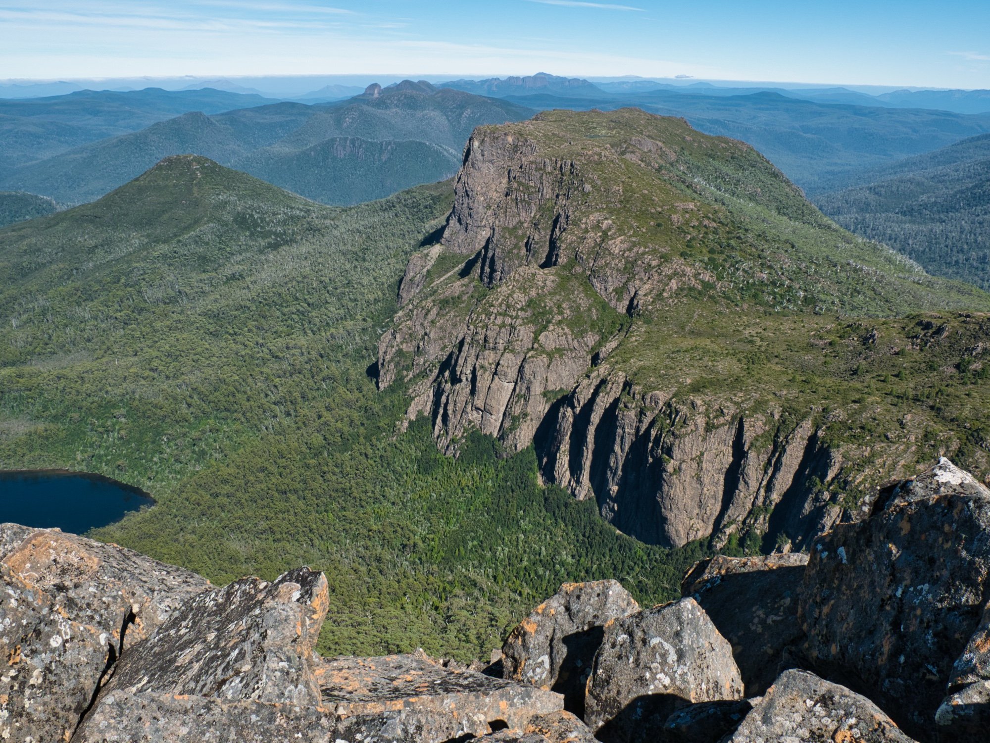
Leaving the summit of Mount Gould towards The Guardians.
After summiting Horizontal Hill the previous day, we now set out sights on Mount Gould. Our plans to high camp on the Gould Plateau had been scuttled by an incoming storm. So instead of a short day trip to the Mount Gould summit, we would have a lengthy day walk all the way from Nichols Junction. And as we were going as far as Mount Gould, why not toss in The Guardians too? As it turned out, we’d just continue on and do the entire circuit! Gluttons we are, gluttons for punishment that is.

The moon still high as we depart camp.
Knowing we had a long day walk ahead of us - which turned out to be an even longer day than we had initially planned - we set off a bit before 7am, with little light managing to penetrate the thick forest overhead.
It was eerie wandering the dark forest, ancient trees illuminated only by our head torches and the occasional glow of a reflective marker. The pad underneath our feet was visible for the most part, even in the low light. We noticed how this track clearly gets a lot more use than the Lake Marion Track as we gained elevation gently for about a kilometre, before briefly levelling out.

Easy walking along the Mount Gould Plateau Track.
From here on until the Gould Plateau, the track would wind in and out of lush green forest or slightly boggy patches of button grass. Unfortunately, it was in one of the lush green forest sections where in a moment of inattention I slipped on a slimy tree root and fell - with something in my back going twang! It would not be polite to repeat the language I used here, but needless to say I was not only in a great deal of pain, but annoyed beyond words that I might have to hobble back to camp whilst Bender continued on without me.
I pulled some pain killers out of my day pack and gobbled a double dose. We decided to rest for a few minutes and see if I could move my back. If so, Bender would take my day pack for a bit and I would grab out a pole and hobble behind to see if movement would settle the spasms pulsing across my back. Hunched over my walking stick, I swear I looked like Dobby out of Harry Potter, as I slowly inched up the track!

Vegetation decreasing in height as we near the Mount Gould Plateau. Lake St Clair below.
Entering another button grass patch, we found someone’s map bag containing what looked like maps and track notes for the entire Du Cane Traverse. We briefly discussed picking it up and carrying it to Mount Gould with us in case we could find its owner, but were worried that they may come back looking for it. So we left it where it was thinking if it was still there on our return trip (at this point we were envisaging an out-and-back trip) we would take it to the ranger at Narcissus Hut. A few more stops, a few more pain killers and hundred more moments of being in awe of our surroundings and we finally made the Gould Plateau.

The “Lookout”.

Views towards Mount Olympus from The Lookout on Mount Gould’s Plateau.
I’m not sure if it was the overdosing on painkillers or the view, but by the time we reached the lookout on the Gould Plateau I was feeling much less pain and much more enjoyment! The sun was out now and the clouds had lifted. The views across to Mount Byron, Mount Curvier, Mount Olympus, Mount Othrys and over Lake St. Clair were spectacular.
Tiny rock pools on the lookout held crisp, cool rain water; we drank from them and felt like the luckiest people in the world in that moment. I grabbed my daypack back off Bender and began to slowly wander across the plateau towards Mt Gould itself. The walking was easy as an obvious pad and the occasional cairn led across the plateau with the now lowish vegetation allowing for 360-degree views all round. Oh, how I wished we could have camped up here the night before.

The Acropolis and Mount Geryon from one of the large tarns on the plateau.

Views towards Mount Byron and Mount Curvier from the Mount Gould Plateau.
As I waited for Bender to catch up from his usual photography shenanigans, I explored the small camping spots around the first few tarns that you reach initially on the plateau. No doubt a lovely spot to pitch a tent, but no real shelter in a storm, so our decision to camp low had been wise. The water level on the tarns was well down as evidenced by the baked mud border around their edges, another sign of how dry this summer has been. Even the much larger tarn further along the plateau was obviously lower than its norm. It would have been nice to have the whole day to explore the delights of the plateau, but we had a long way to go today and needed to maintain steady progress.

Nearing the massive bulk of Mount Gould.

Using cairns to assist with navigation.

Beginning the climb up Mount Gould and looking back down towards the plateau.
In the not too-far-away distance I could spy Mount Gould rising sharply towards the skyline. It was going to be a beast of a climb! We continued on, following the pad to the base of Mount Gould, from here on the occasional cairn would help with navigation. In some places the scrub has reclaimed some of the track so we were paying a little more attention to making sure we stayed on it.
At one point, a distinct pad led in two different directions. Bender followed the left hand pad which was swinging around to the west whilst I headed off on the pad leading to the right. My pad was briefly swallowed by pandani but then opened up again and cairns and tape indicated it was indeed the correct track. Disappointingly though, someone had also gouged a deepish arrow into a boulder: its an unnecessary form of bush vandalism!
Bender rejoined me and after edging around some lovely rock formations we popped out into the most delightful marsupial-grazed terrace! It was like a mini amphitheatre. Short, bright green grass lined the terrace ledges with sprinklings of pineapple grass and pandani. There was even a tiny hidden tarn! It felt like we were stepping through Alice’s looking glass!

Some of the lovely dolerite that flanks Mount Goulds summit area.
The layered banks of green rose above us giving us brief respite from the sun. Such a pretty find in amongst the more aggressive alpine scrub! At first glance, one would automatically want to walk up the grass ledges but a timber arrow shifted my gaze left where I spotted a small cairn and a pad. Best we follow that! Following the cairns we reached the first scree field. Smaller rocks and lots of cairns made traversing across it easy. We were mindful, however, that there was quite a bit of movement in the rock, so kept a safe distance between us, least we dislodge a loose stone.

Yep it was steep in places!

Reaching the first of many boulder fields.
Gradually the small rocks grew in size until they were proper boulders! Not quite Mount Pelion West-sized but massive nevertheless! I was still trying to protect my back at this stage, so my clumsy attempts at scaling some of the more awkward boulders were quite amusing. I felt like we were making super-slow progress between protecting my back and stopping for photos, but glancing at my watch we were still pretty much on The Abels guidance for time. We both commented that we were glad we weren’t attempting Mount Gould in the wet, however, as a fair few of the rocks were covered in dried black algae which is absolutely no fun in the wet.

The true summit area hidden behind multiple minor high points.

Losing a small amount of elevation in exchange for easier walking.
Finally cresting the first high point, I had a brief moment of negativity. Ahead there were multiple more false summits and what seemed like a sea of boulders to traverse before reaching the true high point at the other end of the ridge. In the back of my mind, I was concerned that my back might slow us down to the point of not being able to complete our day’s plan, or - worse still - completely seize up and I would be stuck on Mount Gould and possibly have to set off my PLB.
It was time for a quick reality check. I had enough pain killers to get me through, I had a bivvy bag and warm layers in my day pack should things go truly pear shaped and we needed to spend the night out here. We had plenty of food and if need be I could with Bender’s help more or less roll off the mountain to the tarns to wait out a spasm until I could walk out the next day. My biggest fear was becoming a burden to emergency services if they had to come collect me! Reassuring myself that wasn’t going to happen, I pulled up my Negative Nancy pants and dragged myself up the next big rock!
Views towards The Guardians opening up as we traverse Mount Gould.
We were now traversing the lengthy boulder field towards the summit. Enough cairns led the way but at times we would need to really hunt around for them. Up, down, over, around, through, repeat. This section of the Mount Gould climb would take just as much time on the return journey, and it was here that I was thinking I wonder if Bender would be up for doing the circuit instead of returning the same way. Scrub bashing down Horizontal Hill seemed like it would be much kinder to my back, and likely a faster way to return to our camp!
Standing on the second-last high point before the summit, we assessed the way forward. There was a sharp drop below us so continuing straight ahead wasn’t feasible, and neither was erring west. We headed east dropping some elevation and hitting a small pocket of scrub as we picked our way downwards to where we thought we could cross onto the next high point. Locating a few cairns confirmed we were at least where others have been before! From there it was a simple matter of a few more big boulders to clamber over and we were summit bound! Yay! (Those wishing to do the traverse without going to the summit could contour around the north-eastern side, sticking low on the scree line avoiding almost all the large boulders.)

Finally summit bound!
If we thought the views from the plateau were good, we were in for a very pleasant surprise! The views from the summit are beyond amazing. We could now see The Labyrinth below, The Du Cane Range and as far as Mount Ida as well as our next target The Guardians off in the near-but-not-close distance. Wow, wow and more wow! It was time to sit and enjoy the sun on our backs, gobble a tasty snack and to thank the mountain for letting us climb on her back.

The weird metal structure on the summit of Mount Gould.
Alas, all good things must come to an end and it was time to say goodbye to Mount Gould and continue our journey over to The Guardians. But first we had to get off Mount Gould. As Bender took a few more photos I started slowly down the northern side of Mount Gould. I was just picking my way down as there were no cairns to be located. From where I was it looked like a simple enough challenge until…. I reached the start of an almost vertical drop off. OK - this is NOT the way down!
I yelled out to Bender that unless he had abseiling gear, we needed another route and continued halfway back up to the summit to where Bender was standing. He wanted to climb all the way back up to the summit and then locate the correct gully to drop down to The Minotaur saddle from there. I refused to climb back to the summit (!) and just suggested we traverse across the adjoining cliff’s steep ledges into the gully from our current position. After all we have done Federation Peak - how much harder can the cliffs be?! Famous last words ;-)

The gully descending to The Minatour saddle.

Looking back up the near vertical wall we had somehow managed to scale down!
Said cliff appeared to be a series of steep but - sort of/maybe/hope we don’t die - manageable ledges. At the base of each ledge was a very small vegetated band - enough for a hand hold or two hopefully. Surely we could safely make our way down each ledge using the help of the small pockets of vegetation? Bender initially questioned the plan - after all, I’ve always been the one who’s struggled with heights and exposure - so I just shimmied my way down the first dolerite column and said if he wanted to go the other way he could and I would meet him in the gully :-P.
Maybe he thought if I die, he should too (!) so he shimmed down the first ledge and joined me. As he lowered himself down the next vertical ledge the small root he was holding gave way and he slipped a few metres but caught himself on the next ledge without issue. My turn - I copied him but made sure I used opposing force on my arms and legs to slow my descent. If my mother could see me now she would not be happy….!

The sheer wall we had scaled down using the tiny pockets of vegetation for grip.
With a few ledges under our belt we now weren’t far from the gully but still had yet more vertical columns to descend. Separated at one stage as Bender chose a higher - and probably more sensible route - but in for a penny, in for a pound, I kept picking my way down the cliffs. We met at the bottom in the gully and looked back up the columns we had descended and decided we definitely would not recommend anyone go that way! Instead, leave the summit and stick east as you descend until you reach the top of the broad and manageable gully leading down to the Minotaur/Gould saddle. At least our sketchy descent had cut out a good third of the steep gully for us!
Descending the gully was easy going - though tough on the knees - but we were going slow and carefully as the base of smallish rock was loose and easy to dislodge. Below us we could see the pad across The Minotaur saddle, and we could make out two figures moving across The Minotaur itself.
It was at this stage I mentioned to Bender that we should consider doing a circuit via Horizontal Hill and back to camp via the Lake Marion Track, almost all of which we’d completed in the past two days and knew we could cover at a good pace. Bless him, he was thinking the same and in complete agreement! Happy dance - we would get the circuit in. As we had initially planned to do an out and back, I was bummed we would miss the somewhat notorious drop off The Guardians’ south-western side. Not anymore! Yay!

Nearing the bottom of the gully that would end at the Minatour/Gould saddle.
The tinkling sound of water running somewhere grew louder as we got closer to the saddle. We were both starting to get low on water and discussed whether to use extra time now and try to find the source, or wait until we either found soaks or got to the large tarn on The Guardians. Figuring we’d be making faster progress once on The Guardians flatter plateau itself, we decided to wait. A well formed pad and cairns led from the Gould/Minotaur saddle up the south-eastern side of The Guardians.
It was here we met the hikers we had seen earlier. They had come up from The Labyrinth and were going to sidle around Mount Gould and camp on the Plateau. It didn’t take long at all to reach The Guardians plateau, so I rested under some lovely King Billy Pines while Bender quickly climbed The Minotaur. It was good to lay down and stretch out my back for a moment while nibbling on some dried fruit to restore my energy reserves. I was semi-rationing water but would have killed for a long drink!
As soon as Bender returned it was time to set off on part two of the day’s adventure - The Guardians.

Descending towards The Minatour/Gould saddle.

Looking back towards Mount Gould from the Minatour saddle.

Approaching The Minatour on the way to The Guardians.
The Stats.
Distance: Approximately 8km. Narcissus to Nichols Junction - 2.5km. Nichols Junction to the summit 5.5km.
Time taken: The Abels states 6 hours from Narcissus Hut to the summit. Even with a combination of a minor back injury and lots of stops for filming and photos we were just over that time.
Narcissus to Nichols Junction - 45 minutes.
Nichols Junction to the summit 5.5 hours.
Difficulty: The Abels book route is classified as hard.
Type of track: Tracked to the Gould Plateau. Then occasional pads, cairns and tape to the summit..
Access from: Narcissus Hut or The Labyrinth.

The Map.
From Narcissus Hut to the summit of Mount Gould then completing the traverse across to The Guardians and returning via Lake Marion.