King William II
(Richmond Crag)
Date: 3 April 2022 - Summit: 1363m
Photo credits: Ben Wells, Tracey Orr

Mist creeping over the Range - views from Richmond Crag south towards Cromwell Rise, Restoration Hill and King William III.
A few years back, I spent a weekend hiking in the Blue Mountains. I distinctly remember being more than a little stunned that the locals had brought no wet weather gear with them because, I quote, “there was no rain forecast”. So confident were they in the stability of the weather that they actually believed the weather forecasters! And yes, it didn’t rain that weekend!
It’s perhaps little wonder then that bushwalkers from the mainland and abroad often find themselves sorely tested by our weather conditions - occasionally with dire consequences. That sort of utter faith in weather forecasts is totally absent in here Tasmania - and with good reason. Our weather shifts and oscillates in the blink of an eye, particularly so of the alpine regions of the south and central west, above 1000m elevation. Forget forecasts: each mountain range and adjacent valleys generate their own microclimates. Sun, snow, mist and wind can be separated by mere kilometres, be it January or June.
We were reminded of this fact - not that we needed reminding, even if our run of weather over the past summer had seemed better than average - over the 48 hours spent on the King William Range. Little did we know that after summitting Slatters Peak in glorious conditions and lounging like lizards at Lake Anne less than 24 hours earlier, that we would wake the next morning to icy-cold winds, rain and thick mist that reduced visibility to less than 50m. In true Tasmanian style, the weather had thoroughly ignored the best predictions of the BoM and shown us that you are always, always at the mercy of nature.
Waking to a white out.
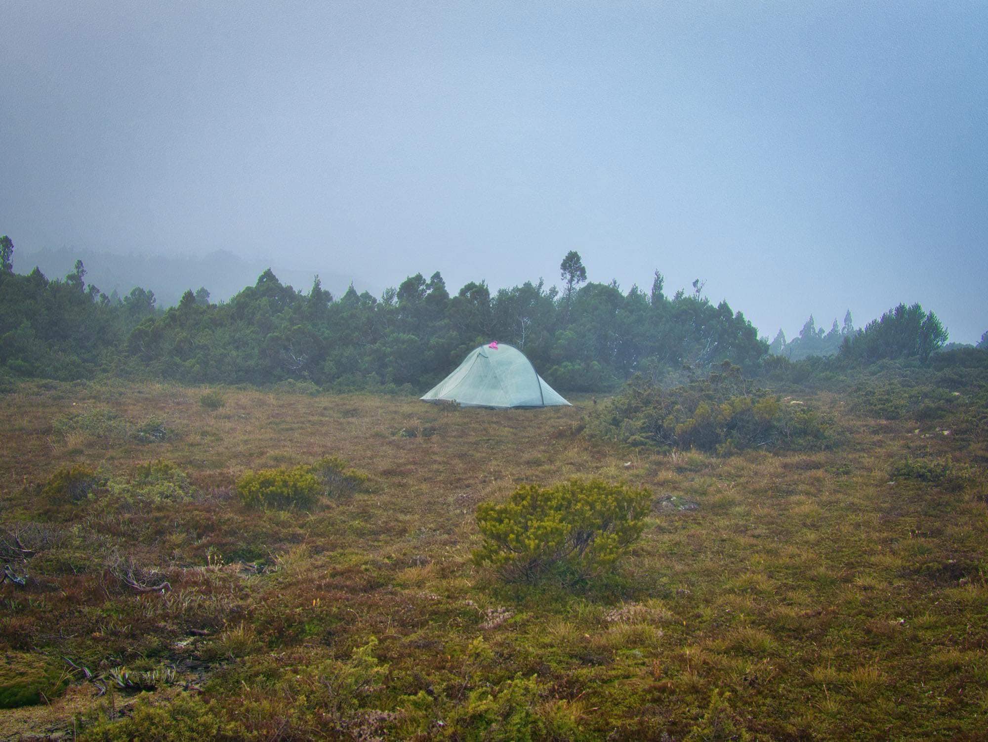
I had listened to the sounds of the wind and rain hitting the Dyneema fabric of our Tarptent during the night, and been grateful Bender had insisted we pitch our home within a nook of sheltering vegetation. Protective, head high scrub flanking us on all sides bar directly west to Lake Anne, ensuring the worst of the wind gust over rather than through us. Our planned super early start was delayed as it was not yet light out when our alarms went off, despite the end of Daylight Savings giving us an extra hour’s sleep.
The sun was trying its best to poke through the low cloud but was losing the battle. A thick blanket of wet white mist shrouded everything. Visibility was measured in metres and a light drizzle was falling. The mist meant we’d be setting off in full wet weather gear, and relying heavily on GPS to route find on what is otherwise considered a straightforward walk.
We’d used our lazy afternoon the day before wisely, not only resting up weary legs but also sighting which minor hill we would aim for to get us up onto the ridge. Of course with zero visibility now, that had proved a pointless exercise!
Finding enough low vegetation for easy passage.
Moving slowly in the dull conditions we crossed the tributary at the eastern-end of Lake Anne. The ground beneath us was a mix of boggy grasses - cropped short by the local fauna - and spongy pineapple grass. We headed south-sou-westerly initially, picking our way through small bands of lower vegetation and skirting miniature tarns and water courses along the way. If visibility had allowed, we could have seen Lake Anne to our right and Lake Eleanor to our left.
Walking in minor whiteout shrinks your world, to only what you can see the next few metres in front of you. I quite like this eerie sort of wandering. Heavy mist hides the scrub and hills beyond, and draws your focus to the small things your feet pass by instead. Friends had told us that it would be whilst climbing up and onto the ridge leading to King William II that we would encounter patches of more challenging scoparia and fagus.

Climbing up onto the ridge that we would use to reach King William II.

Breaching the rim of the ridge.
Perhaps our limited visibility worked to our favour, as we were lucky enough to use the frequent patches of pineapple grass and small rocky deposits to gain access onto the ridge without encountering any scrub higher than our calves. Mind you, what the pineapple grass saved us in scrub it made up for with squishy instability. Every step we took required extra energy to stabilise ourselves on its soft, uneven terrain. Its silvery green leaves were almost reflective in the morning’s mist. Despite all the rest, our legs were soon groaning as we clamoured over it. I am sure its the grass equivalent of the fatiguing mud the day earlier!
No longer protected from the icy winds as we navigate the rock outcrops alongside the western side of the King William Range.
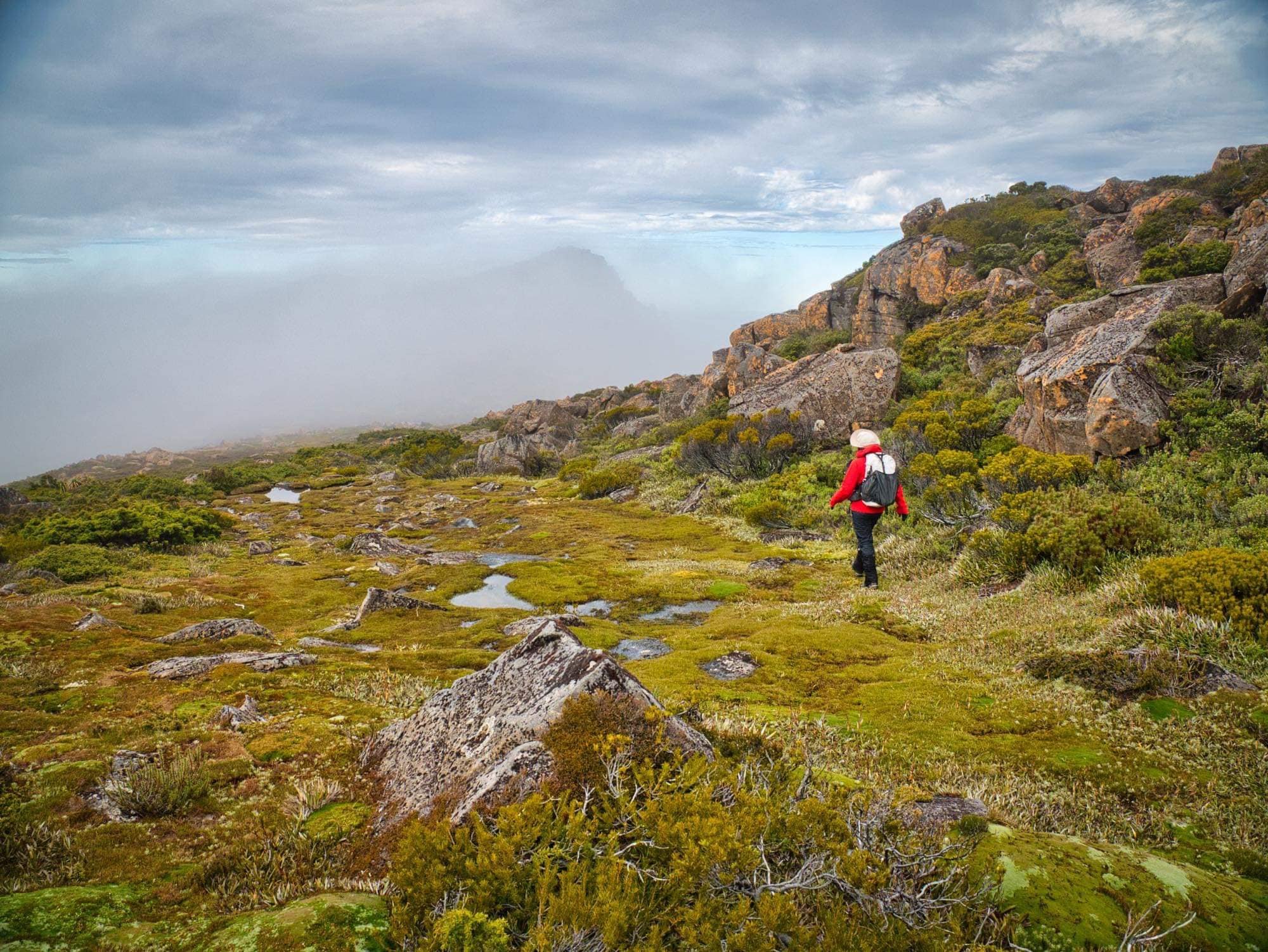
As we pressed on, we would get the briefest of moments where areas of mist would disappear and reveal some kind of view and patches of blue sky in the distance. Whilst Bender quickly snapped away with his camera, I would try to commit to memory the next section forward. Then almost as instantly as the mist disappeared, it would suddenly swallow everything up again! Bender growled with frustration as compositions appeared and vanished within seconds.
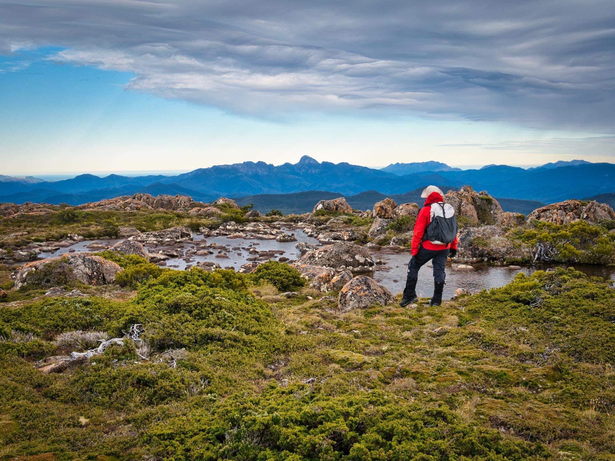
Once higher on the ridge we were no longer sheltered from the wind and had to yell across to each other to communicate. The benign drizzle had morphed into steady rain which was falling steadily. The mist was persistently blocking visibility beyond 10-20m ahead and it was cold! Still, we had faith that the sun would eventually win out as predicted - everywhere beyond our range to the west, south and east was actually clear - and so we continued along aiming for a large rock outcrop towards the end of the ridge.
A brief moment of clear skies at the miniature tarns near King William II summit.
Skirting the outcrop would have been easy enough in the dry, but the rock was wet and slippery, requiring caution when crossing the somewhat awkwardly sized boulders, covered in moss. In places, just enough scrub to be annoying filled the gaps in between the rocks. We tried skirting low on the rock, then changed tactics and climbed a little higher when the scrub between the boulders became troublesome. On the return journey (with the benefit of visibility) we would instead go straight over the outcrop.
I was sure the sights would be glorious on the ridge, if only the weather gods would play nice! We would get fleeting glimpses of the sun shining on Frenchmans Cap to our near-west, lifting our moods only to be squashed again when the next tuft of mist blew in.
A quiet ding from my phone punctuated the wind as we wandered along: I hadn’t realised I had not switched flight mode on. It was a message from a a friend to say he was on the summit of Mt Jukes, in the sun, looking across to us and we were the only range he could see under cloud! Typical!

Mist swirling in all directions around us.
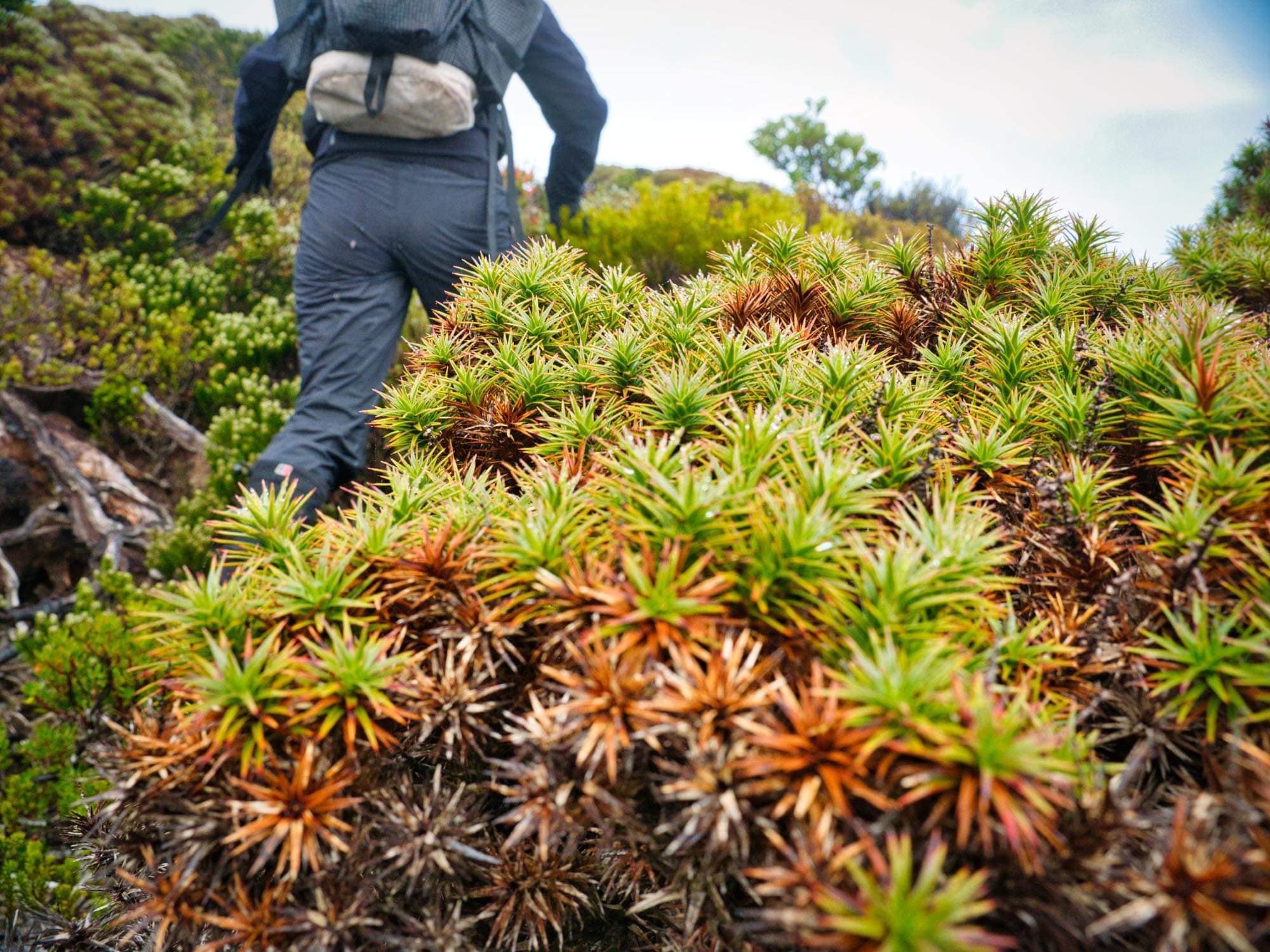
Mind you, even if the clouds had lifted and allowed for views, our eyes would have remained cast down at our feet. Gone was the pineapple grass, calf high scrub and small bands of scoparia. Instead we were walking amongst low heath interspersed with bright green cushion plants! Fat kidney-bean shaped mounds, tiny round pillows and every size and shape in-between!
Weaving around them all was like negotiating a minefield - more like dancing than bushwalking! Some masses were so close together and dense we needed to be on tippy toes to avoid them, lunging or jumping for the more durable grass in between. Anyone looking on it might have thought we’d indulged in a breakfast gin, such were our odd gaits!
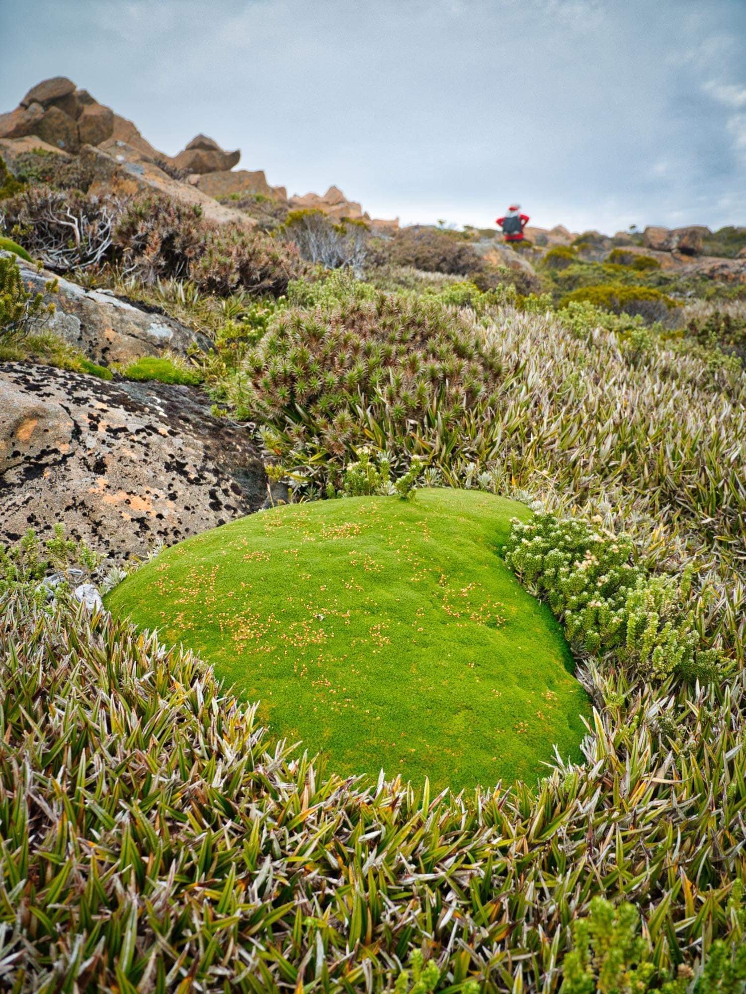
Exquisite cushion plants litter the plateau.
Passing by the minature, jewel-like tarns before the named summit of King William II (note summit - not Abel) our persistence was rewarded with a few more fleeting moments of clear skies as we looked across towards the Tyndall Range and Frenchmans Cap. The rain had also decided to stop (for now) and we could at least lift our hoods off, if not remove the wet weather layers entirely.

A gorgeous bunch of pandani en route to Richmond Crag. Mist still hugging the lower side of the Range to the east.
En route to Richmond Crag - hidden in the mist.
From the tarns it took only minutes to climb onto the small rocky outcrop that marks the summit of King William II. Thanks to the mist there were few views to be enjoyed, so we set off quickly towards Richmond Crag, the informal name for the King William Range high point Abel that lies further south.
The officially named summit of King William II and the actual Abel are two different beasts. What the map refers to as the summit of King William II sits a mere two metres lower than the true highest point, approximately 1.5km separating the two points.
Note: while the name and elevation point of Richmond Crag appears on most electronic maps (Garmin, OpenStreetMap, etc.) it isn’t an official name with the Nomenclature Board of Tasmania and thus doesn’t appear on ListMap or the current TasMap. Bill Wilkinson suggests the alternative name “King William Range High Point “ for the Abel, akin to the (similarly confusing) Du Cane Range High Point. “King William IIb” or “KWIIb” has also been used to identify the ‘second’ high point of the Range.

Heading towards Richmond Crag from the summit of KWII.
Leaving the summit rock we headed south-sou-westerly again. Our walking was mostly now on spongy sections of pineapple grass and sporadic deposits of rock, as we descended down slightly, dropping a small amount of elevation into the adjoining saddle. We would regain this elevation plus the two extra metres when we climbed the dome-shaped peak of Richmond Crag, which was still hidden in mist ahead with just a faint shadow indicating its presence.

Views from Richmond Crag, looking north along the western ridge of the King William Range traversed.
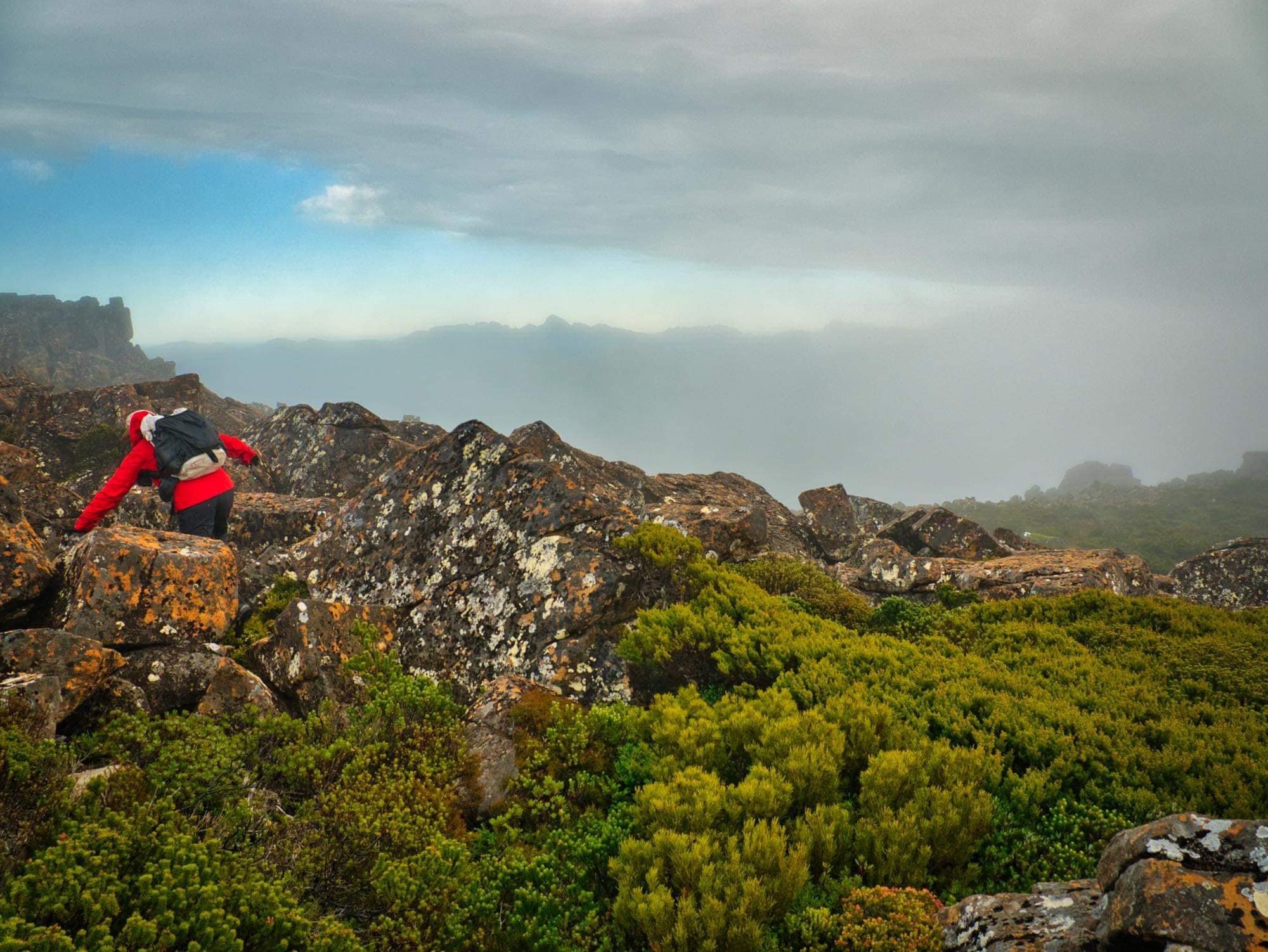
Once at the northern-eastern foot of Richmond Crag, we turned west and a brief, straightforward rock scramble had us on the summit of the actual Abel! Yay! The excitement was short lived however as the heavens decided to open again. I yelled over to Ben and indicated I was going to drop slightly off the summit and take shelter to warm up and eat, while he “tried” to get some photos.
He soon gave up and joined me in a sheltered gap between the rocks for some food, in the hope that the weather would clear for a few minutes if we waited… which - surprisingly - it did! The mist didn’t clear entirely but it did drop low enough for dramatic views across the Range itself, as well as out west over the Loddon Range to the Frenchmans Group and beyond. After a few more photos, we turned back towards Lake Anne and, knowing we had a lot of walking left for the day, began retracing our steps. The morning was still young, but we had to get back to camp, pack up and walk out.

Heading back towards KWII summit. Weather now clearing… of course!
As we wandered back the patches of beaming sun warmed our faces for the first time, and we absorbed the views that we’d been denied on the inwards journey. We still had big day to get back to the car, but at least now we had some decent weather, right? Wrong!
Before we had even returned the 1.5km to the King William II summit, the rain started again and had us refitting the wet weathers we’d only just taken off. Talk about four seasons in one day! Picking up the pace we began the wet and windy march back towards the tent. By the time we reached it the rain had increased, so we took shelter inside the tent for half hour, or so hoping it would pass while we had an early lunch and finished packing our gear. But alas, it wasn’t to be.

Dropping off the KWII ridge and approaching Lake Anne (left of screen).
We weren’t going to get our way, so resigned to packing up the tent with the wind blowing and rain running down our faces before setting off towards Slatters Peak and home. I pleaded with the universe to at least stop the rain as we traversed the slippery boulders up towards the high point on Slatters. Alas, the universe ignored me completely, with the rain only relenting once we’d already made the painstakingly careful traverse of the ridgeline and back in the scrub on the northern side of Slatters Peak. Damp vegetation made for plenty of slip and sliding, but at least gravity meant we eventually popped out onto the button grass over an hour faster than we’d climbed it the day prior.
Still, the character-building weather and scrub had us appreciating the Mazda when it finally came into sight as the sun was setting. And very much increased our appreciation of a hot bowl of soup at the Derwent Bridge Hotel on the way home.
The Stats.
Distance: Approximately 10km
Time taken: 4.5 hours return from Lake Anne to the summit of KWII and Richmond Crag and return.
Difficulty: In good weather with clear visibility we would classify from Lake Anne to Richmond Crag as relatively easy off track walking. All the usual precautions still apply when spending extended periods of time in elevated, exposed areas, of course.
Type of track: Untracked.
Access from: Lake Anne

The Map.
Route taken from Lake Anne to Richmond Crag (via KWII) and return.