The Hippogriff
Date: 21st October 2023 - Summit: 1109m
Photo credits: Ben Wells, Tracey Orr

The Hippogriff viewed from the Lake Dixon Track.
With spring weather bringing storms, extreme wind, snow and just generally maniac conditions, we had had to postpone a trip to the Cheyenne Range and Mount Gell a weekend prior. Of course the following weekend, where we only had one day without commitments, the weather gods seemed to want to play nice and so I planned a day trip to The Hippogriff.
Bender had summited The Hippogriff a year earlier with a mate, so I was planning on a solo adventure. But he decided to come along, as he wanted a stretch of the legs and hopefully to see if the views from the summit that had alluded him on his previous trip.

Leaving the Mazda at the trailhead on Rufus Canal Road.
As we loaded up the Mazda at the ungodly hour of 4:45am, the last-minute weather changing gods were threatening to rain on our parade again! Bugger it, we thought. Who cares if we get wet?! It’s fairly sheltered until the summit, and it’s a day walk. We would be returning to seated heats in the Mazda by the end of the day, so we decided to try our luck. What’s the worst that can happen?
Before even slipping our walking boots on, we had the long and ever so slow drive from Launceston to Rufus Canal Road, just west of Derwent Bridge. Driving in wee hours through the central highlands means wildlife and so I was creeping along, top speed of 60kph.
Even my over-cautious driving couldn’t avert disaster though, when a huge wallaby jumped straight out in front of the car, hitting the front bumper with that gut wrenching thud that no one ever wants to hear. We pulled straight over and Bender jumped out to check on the poor critter as I sat in the car crying. I was so upset that I might have caused pain or death to an animal. I felt physically ill by what I had done, and was ready to turn for home and call it a day.
Bender reassured me that the wallaby was fine as it had immediately bounded away. The same couldn’t be said for the Mazda’s front bumper. I didn’t care about the car, I was just glad the critter was ok. As I was shaken he took over the driving from here, doing his best to distract me. A few hours later and thankfully no more altercations with wildlife, we were pulling into the very small parking area at the start of the Lake Dixon Track.

Disappearing into the Lake Dixon Track.
We have “navigated” this track a couple of years before when doing The Chimera. Bender again “navigated” it on his previous trip to Mt Gell. The reason I say “navigated” is because for a marked and seemingly long-established trail it is surprisingly easy to lose the pad in places. It’s overgrown with lots of blowovers hiding the pad in key sections. A good number of the old flagging ribbons have since gone crusty and fallen to the forest floor, offering no useful guidance.
As it was a day walk for us, we had discussed the night before combining our day walk with doing a little track maintenance on the Lake Dixon Track. This would not only benefit our walk back out, especially if it was dark, but also benefit any other user of the track in the future. I had a pocket full of pre-cut flagging tape to replace old degraded stuff and we planned on making a slower descent to allow time to clear the pad a bit.
The track was more overgrown since we had last visited, and almost from the get go we were clearing fallen branches, picking up old tape that had fallen on the ground (taking the old stuff out with us, as it just disintegrates if left on the ground) and replacing it with fresh pieces where necessary.

One section of the Lake Dixon Track that is almost too well marked!
We wandered along, quite enjoying a bit of track maintenance. Laying sticks across false leads to visually block them off, doing our best to clear sections covered by the winter’s fallen branches and generally trying to restore the track to a little of its former glory. At the same time we chatted about who still uses the track beyond the committed peak baggers to the area. Bush walkers? Fishermen? By the looks of it, a fair few native animals too.
By the time we had reached the lake’s edge we were quite pleased with the morning’s efforts. Even better, the weather was holding - not a spit of rain so far. Mind you, we were still in wet weather trousers as the forest was wet from previous day’s rain. Our track maintenance stopped at the campsite near the edge of the lake because, well, the track stops there!
From here on in, it is a choose-your-own type of adventure. We had Bender’s GPS route from his previous trip but had already agreed that if I found an easier way through the scrub loosely following it, so be it.

Nearing the lake.
It was only fair that I lead 99% of the way, as Bender was keeping me company. I didn’t mind leading as I quite like The Hippogriff’s type of scrub. It is the sort of bush that doesn’t require brute force, but rather slow and methodical ducking and weaving. With that in mind, we wound in and out around the tea tree and forest that guarded the first of many button grass fields we were aiming for. Animal pads helped us through, as did the welcome find of two strategically placed ribbons along the way! It’s always reassuring knowing someone else was lost in the same place as you!
We were sticking closing to the northern side of the lake, but a little back from its shores to avoid the dense scrub lining its edge. When we hit the first button grass plain we would continue around the northern edge of the lake, but begin to arc west.
Button grass is far from my favourite terrain to walk on, but as far as button grass goes, this really wasn’t too bad. Nothing like the hideous torture that makes up so much of Pokana Peak! It was reasonably flat, the mounds weren’t huge and the only annoyance was the squishy mud hiding in between the clumps, which would suck a boot in before you realised it was happening.

Into the denser scrub bordering Lake Dixon. A random pink tape in the middle of nowhere!

One of the many button grass plains we travelled across.

Avoiding small pockets of wooded forest that bridged the button grass fields.

More open pockets of tea tree broke up the button grass and small scrub bands before we reach the Franklin River.
With me leading and Bender bringing up the rear firing away on multiple cameras as usual, we were in our element. Both of us happy to be out walking and both of us genuinely surprised at how the weather was panning out. We had had to remove our jackets as we were already too hot, and hadn’t really done any scrub bashing or climbing yet.
Using the aerial imagery on GaiaGPS we jumped from scrub patch to button grass, to scrub patch to button grass. This pattern continued until we neared the rocky narrows that we would use to cross the Franklin River, approximately 1km north of where it drains into Lake Dixon. I had been nervous about this part of the trip, as I hate water crossings and I really hate swollen river crossings! Those nerves increased at the none too quiet sound of water rushing down the river before we could even see it!
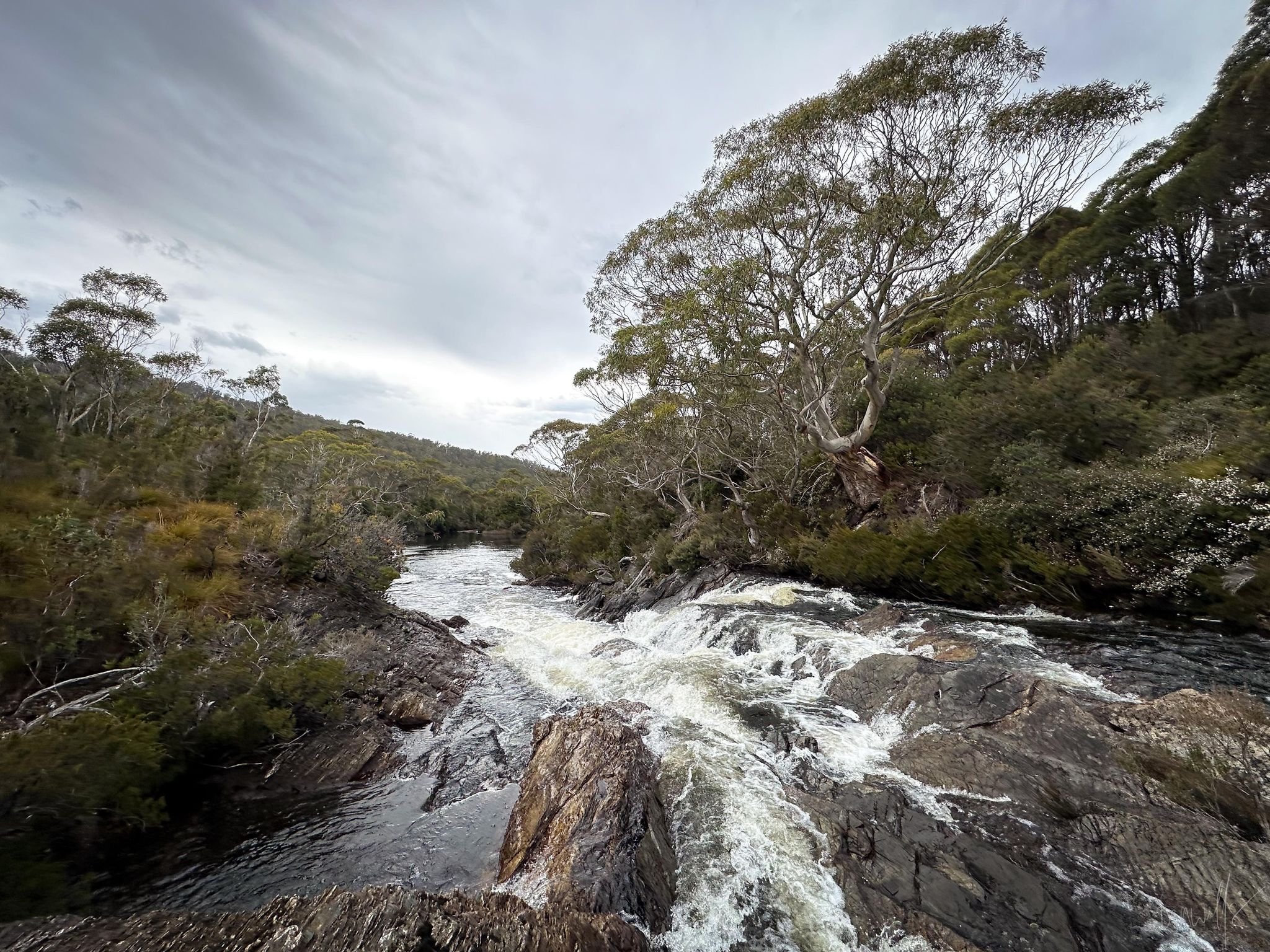
The crossing point at The Franklin.
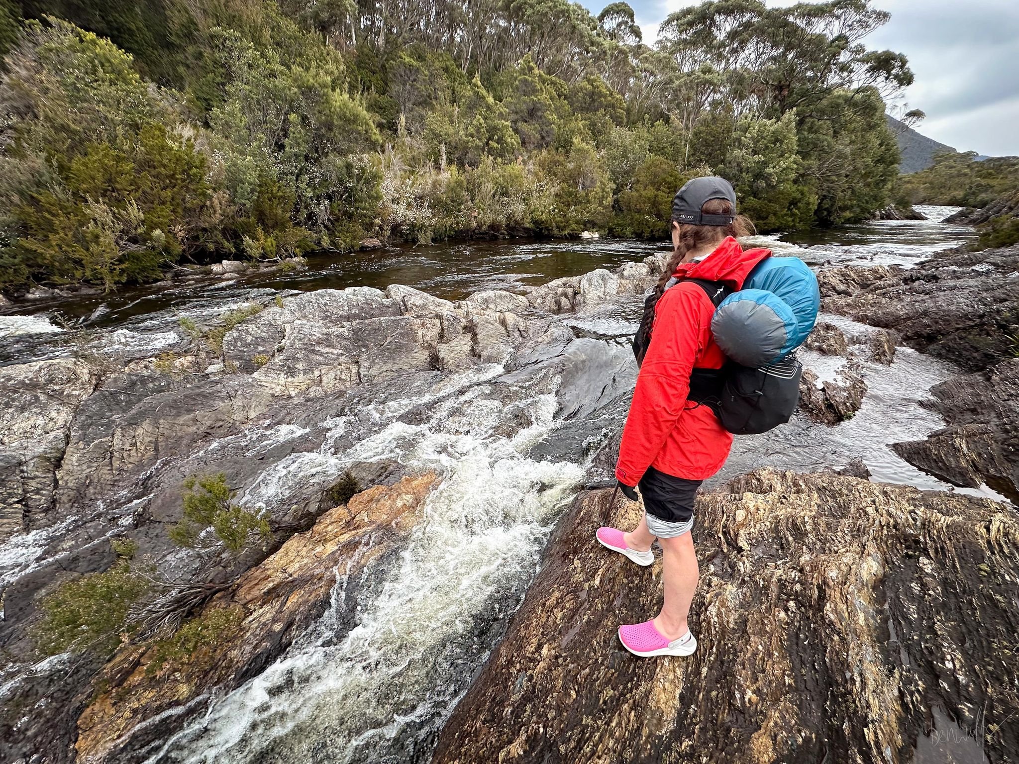
Ben had mentioned he’d been able to cross the Franklin without wetting his boots on the previous trip, but recent rainfall meant that would be unlikely this time around. That was immediately confirmed as soon as we saw the height of the water. Needlessly wet boots are never fun, so we had packed our Crocs to cross the river in. We figured we could hang them in a dry bag on the other side and collect them on our return, saving weight and bulk for the rest of the trek. As I sat and changed my boots and contemplated running straight home and away from the fast flowing river, Bender had a little look-see to figure out a path across the maze of rocks and rapids in between.
Bender led while I followed, pole in one hand to brace from the current and hanging onto his other hand for security. It was like a parent holding a toddlers hand to cross the road.
We had both rolled up our wet weather trousers but as the water was nearly thigh deep on me there was no escaping a cold wash of the legs! Bender being taller only had water up to his knees.
Soon enough though we got across without drowning (!). We gave ourselves a few minutes to carefully towel our feet before redonning our still-dry boots, hanging our Crocs off a nearby tree and steeling ourselves for the hardest part of the day.

Removing our boots to change into crocs to cross Franklin River.
It’s now or never!
From the crossing we would have raised rocky outcrops surrounded by scrub bands and flattish button grass gullies to pass through before the climb would gradually start. There were no formal pads but enough animal pads to make picking through the forest easy enough. I led through and was quite surprised at how un-scrubby (is that even a word) it was. Don’t get me wrong, there was tea tree or ankle and face grabbing horizontal, but it was tedious rather than difficult. The tea tree could be coaxed apart and the horizontal weaved between, and so I was quite enjoying it thus far.
It was at the top of the first hill out of the river crossing that we finally got some good views up towards the summit. Even better it was clear! No rain, cloud or mist hiding it! We were hoping it stayed that way.
Looking ahead, we could see the way forward from our higher up vantage point. Not unlike the rest of the walk thus far, there was scrub and button grass that would lead us to the foot of the saddle between The Chimera and The Hippogriff. Across from us, we could see a decent chunk of rock rising in the direction we needed to go, so decided to cross to it. It would be a easier to walk on than button grass. Even though it would be short lived we figured why not!

Climbing up and out of Franklin River valley using the more open forest.

At the top of the minor climb out from the Franklin River, allowing some views forward.
Using the sporadic rock, button grass sections and skirting the small pockets of vegetation we made short work of the crossing to the scrub that defends the saddle. Bender had warned me that from here on in it only got worse. There was nothing to do but grin and bear it. In we plunged!

Using small pockets of rock to avoid some of the scrub.
Here was the first time we encountered genuinely annoying vegetation that needed a little brute force. That combined with the fact that we were now climbing upwards meant that we were working hard. The air was muggy and warm and we were sweating. I had expected the scrub to stay like that all the way to the saddle but it didn’t.
In fact, it was really short lived and soon we were in more open forest. It meant lots more climbing over fallen logs or slipping through holes covered by forest litter, but it was very preferable to the hard, somewhat impenetrable band of waratah, melaleuca and horizontal at the base.

Time for the scrubbiest part of the day to start!
Up, up and up we pushed. Sure, it wasn’t anywhere near as steep as our recent climb up Eldon Peak but it was still a work out. Perhaps the most tiring part was constantly seeking a route forward. Choosing carefully allowed us to make easier progress through the bush, but comes at a cost of concentration.
We had already decided that instead of climbing all the way up into the saddle, as it appears most walkers do, we would instead stay on the eastern side of it and cut across diagonally towards The Hippogriff. That way we would gain elevation at a gentler angle while shortening the distance travelled. Bender’s previous trip had confirmed the top of the saddle was no more clear or easier to walk through. It worked well for us and we reached the tea-tree covered saddle quite quickly (the eastern side of it at least).

Not the worst scrub we have ever pushed through. More annoying than difficult.
Once again we ducked, weaved and moved consciously through the tea tree, just parting it where necessary, never actually having to fight it. We stopped to snack and to drink every so often but never for more than a few minutes, in order to keep a solid pace and not let the day get away from us. After all, we’d have to repeat all this to get back to the car! Surprisingly - and a little annoyingly, as we’d carried lots of water with us from the Franklin River just to be safe - we located multiple running water sources along the way. Mind you, most would most likely not be there in the height of summer.

Descending to the base of the saddle between The Chimera and The Hippogriff.
As we reached the final patch of button grass that lies just at the southern base of the summit of The Hippogriff, we again remarked at how well the weather was behaving, and how we would not enjoy this walk in the heat of summer! The only positive in summer would be you would be guaranteed to see lots of snakes given the proximity to water, the lovely button grass and forest. We had seen some lovely specimens on trip to The Chimera years ago, but disappointingly none so far today.
Leaving our last patch of button grass we headed into bush again for the final climb. Once again, I was pleasantly surprised by the lack of really dense vegetation. I think The Eldons have totally adjusted my scrub barometer!

Looking towards Mount Gell from the base of The Hippogriff. The final patch of button grass and coral fern.

The final band of scrub between us and the burnt out section higher up.
As we climbed I chose a path that clung to the very edges of the large boulders or small cliffs scattered this side of The Hippogriff. Sticking close to the boulders avoided the denser pockets of scrub and gave us good hand holds to haul ourselves upwards. I was still nursing a pesky wrist injury on my dominant hand, so Bender would occasionally give me a leg up some of the more ambitious climbs.

Scrub, broken timber and steep inclines. Yay!

Sticking close to the jumble of large boulders as we climbed higher helped us avoid almost all of the thicker scrub.

Very close to breaching the easier burnt out section.
We hadn’t long started the final scrubby ascent when I was surprised to lift my head from yet another a boulder climb and see a burnt piece of timber in front of me! Not because it was burnt: like so many areas of southern and western Tasmania the area saw bushfires in 2018-2019. But because it seemed the “terrible” section had been over all too soon. Even Bender seemed surprised: “oh, we’re here already?” Lucky (or careful?) route finding had avoided hard work scrub bashing!
Crunch, crunch, crunch was the sound of dry sticks under my boots and the area around us became an apocalyptic moonscape. Barren, burnt, clear… and then I tripped over! Only I could have completely open walking and fall on my face!

The burned sections enabling faster progress.

Final push to the summit. Not much in our way now.
Here, out of the shelter of forest, the wind was whipping up a frenzy but thankfully it was neither cold nor wet. Our travel over this section was quick and straightforward. The almost total devastation of fire on alpine vegetation and much slower process of regeneration compared to lowland eucalypt forest would see to that. Nonetheless approaching the rocky ridgeline in short order, the summit high point in view and just moments away and there would be glorious views to be enjoyed!
I raced on ahead whilst Bender took his time with photos, before rocketing up to join me in time that we could both touch the summit cairn together. And what lovely views we had.

Looking back down towards Lake Undine, with Mt Hugel looking on.

Looking west towards Australia Tarn with the massive expanse of Mt Gell behind.
Across to the imposing Mount Gell and over to Mount Rufus, its large beehive summit cairn visible clearly even from here. All the way across to the scrubby hill that is The Chimera. We could even see Frenchmans Cap, though to be fair, get high enough almost anywhere in Tasmania on a clear day and you can make out Frenchmans Cap.
It was time to enjoy a well-earned lunch of fruit buns and jelly beans! From the car to the summit had taken just under 5.5 hours. That had included all the time spent on ‘maintenance’ along the Lake Dixon Track, as well as fussing with swapping boots etc at the Franklin River. We were confident gravity would help us be slightly quicker on the return, so didn’t hurry to leave the summit. Or rather, just down from the summit in the lee of the oncoming winds that were uncomfortably strong by this point.
But ever conscious that the weather gods’ mood might change any moment, we polished off lunch, thanked The Hippogriff for letting us climb her back and started our descent. Our plan was to descend pretty much the same way we had come. According to Bender our ascent had been the least scrubby of either direction from the previous trip. No point messing with what had worked well.
I led us home to the creek, with Bender occasionally letting me know to err a little more east or west when necessary, as I was just navigating by feel and memory for the most part. A quick change of shoes at the creek (mostly because we realised we had sat on our jack jumpers nest to change!) and we waded back into the cold water. This time it was refreshing on our tired feet!
We took the opportunity to have a final snack, drink our fill and enjoy the moment as it was just going to be a trudge back from here. Left foot, right foot, repeat kinda thing.

Appreciating our track clearing efforts of the morning. It made for a much easier climb out of the lake!
Mind you, as we dragged our weary selves back up the Lake Dixon track we remarked how lovely it was that the track was now in a much better condition, and more clearly marked. “What lovely people had done the maintenance” we joked amongst ourselves as wayfinding and false leads were avoided in place of a straightforward walk, with just the lightest sprinkling of rain falling as the final kilometre was reeled in.
It was less than 4.5 hours later that we popped back out of the scrub and the Mazda came in to view. Time to remove the many, many, many leeches we’d picked up along the way and get into some comfy dry clothes. Just as we lifted the boot of the car the first real drops of rain fell on our faces. What timing! How lucky were we?
Indeed, not long after we’d changed and started driving back home, an absolute monster storm would hit us. Lightning began to light up the sky all across the central plateau and cracks of thunder shook the air seconds after before the rain fell hard. But by that stage we were drinking coffee and eating burgers at the Lake St Clair Lodge, recounting the memories of a day well spent and appreciative that the weather gods had - for once - smiled upon us this weekend.
The Stats.
Distance: Approximately 11km return.
Time taken: 5.5 Hours from the car to the summit which included filming and spending some time doing maintenance on the Lake Dixon Track. 4.5 Hours to return from the summit to the car.
Difficulty: Moderate. Good navigation skills are required once off the Lake Dixon Track as there is no formal track to the summit. Being in scrub for most of the walk can be disorientating for those without good navigational skills.
Type of track: Untracked but very occasional pads.
Access from: Rufus Canal Road.

Route to The Hippogriff.
The Map.
Route taken to The Hippogriff.