Horizontal Hill
Via the Lake Marion Track.
Date: 18th February 2022 - Summit: 1254m
Photo credits: Ben Wells, Tracey Orr
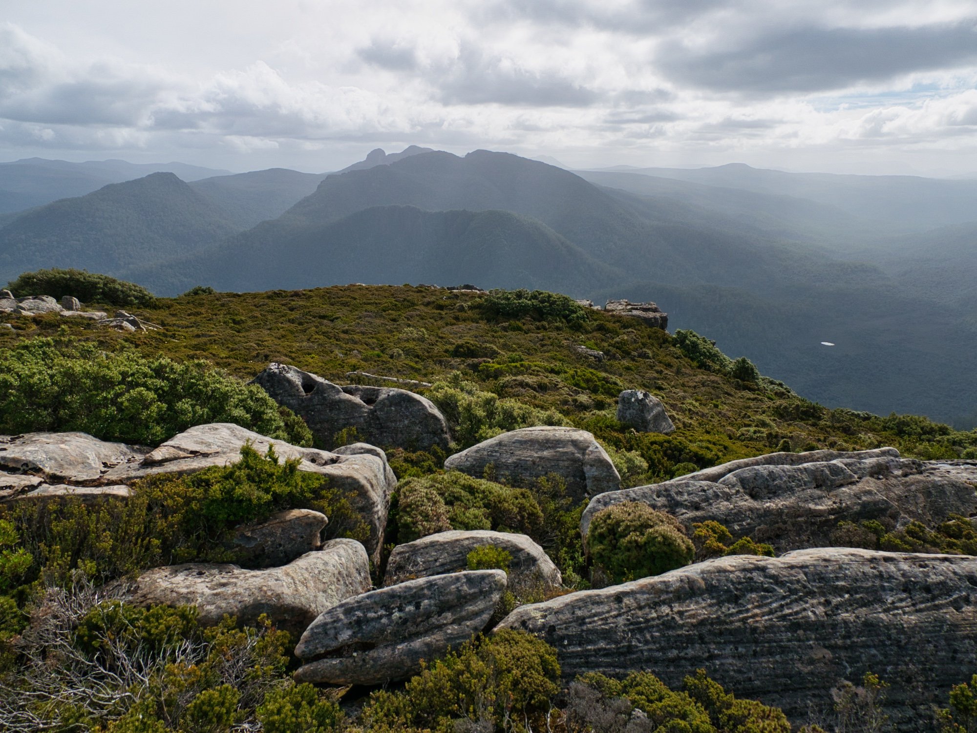
Views towards the south-west from the summit pf Horizontal Hill.
With plans to traverse the Southern Ranges yet again tossed aside because of typical south-west Tasmanian weather (!) we settled on a shorter adventure closer to home. Whilst the weather still wasn’t great around the Du Cane Range, it was decidedly better than further south, and we’d have more sheltered options within the Cradle Mountain-Lake St Clair National Park. We turned our attention to Horizontal Hill, Mount Gould and The Guardians.
Typically these three mountains are done by way of a traverse, with at least one night’s camping up high on either the Mount Gould or The Guardians plateaus. We already knew we likely wouldn’t have a safe weather window for a traverse so changed out itinerary into a split trip - one to visit Horizontal Hill via Lake Marion, and a long day walk for the other two peaks. Little did we know we would end up doing the traverse anyway. What’s that saying about best laid plans?

The ancient sign indicating the track to Lake Marion and the Gould Plateau.
We enjoyed a leisurely (by our standards) start to the day, leaving Launceston around 6am having booked the 9:00am ferry leaving Lake St. Clair to Narcissus Hut. A good giggle over an overcooked egg at The Hungry Wombat Café had us smiling through the drizzle as we pulled into the carpark at the Lake St. Clair Visitors Centre. We were a bit early so Bender went in to confirm our booking - there are more often than not errors and confusion with ferry bookings.
True to style the ferry operator had us booked on the wrong ferry - they had us returning from Narcissus at 9:45am. After wasting time explaining the error and rebooking ourselves on the very-soon-to-depart ferry we hurriedly pulled on our boots and packs, and raced down to the jetty just in time to get on the ferry departing for Narcissus. The pilot is a lovely chap, recognising us from previous trips and really is an asset to the ferry service. The booking system not as efficient! A few odd looks were directed at us by returning passengers as we stepped off the ferry and walked off into the rain. Clearly a few people were wondering why we would head off in this weather!

Remnants of old track work on the Lake Marion Track.
Our “rough” plan was to walk straight into Lake Marion via the Lake Marion Track, make camp and then if time and weather allowed, summit Horizontal Hill from there. The faded old timber sign just past Narcissus Hut stated approximately 2.5 hours from that point to Lake Marion - it would take us three hours. By now the weather had improved dramatically and we were enjoying the stroll, as well as filming and taking photos. I suspect that when said sign was carved many (many!) years ago, the track itself was in better condition. More on that in a bit.
The Lake Marion Track as far as the Gould Plateau Junction (known as Nichols Junction, the site of a now non-existent hut) seemed quite well maintained with little forest debris blocking our passage and frequent enough cairns, ribbons or reflective markers to make navigation a non-issue. Even chatting and frequently stopping for photos we reached Nichols Junction in 50 minutes or so. (This same section would take us less than 30 minutes on the return journey as we weren’t stopping for photos).
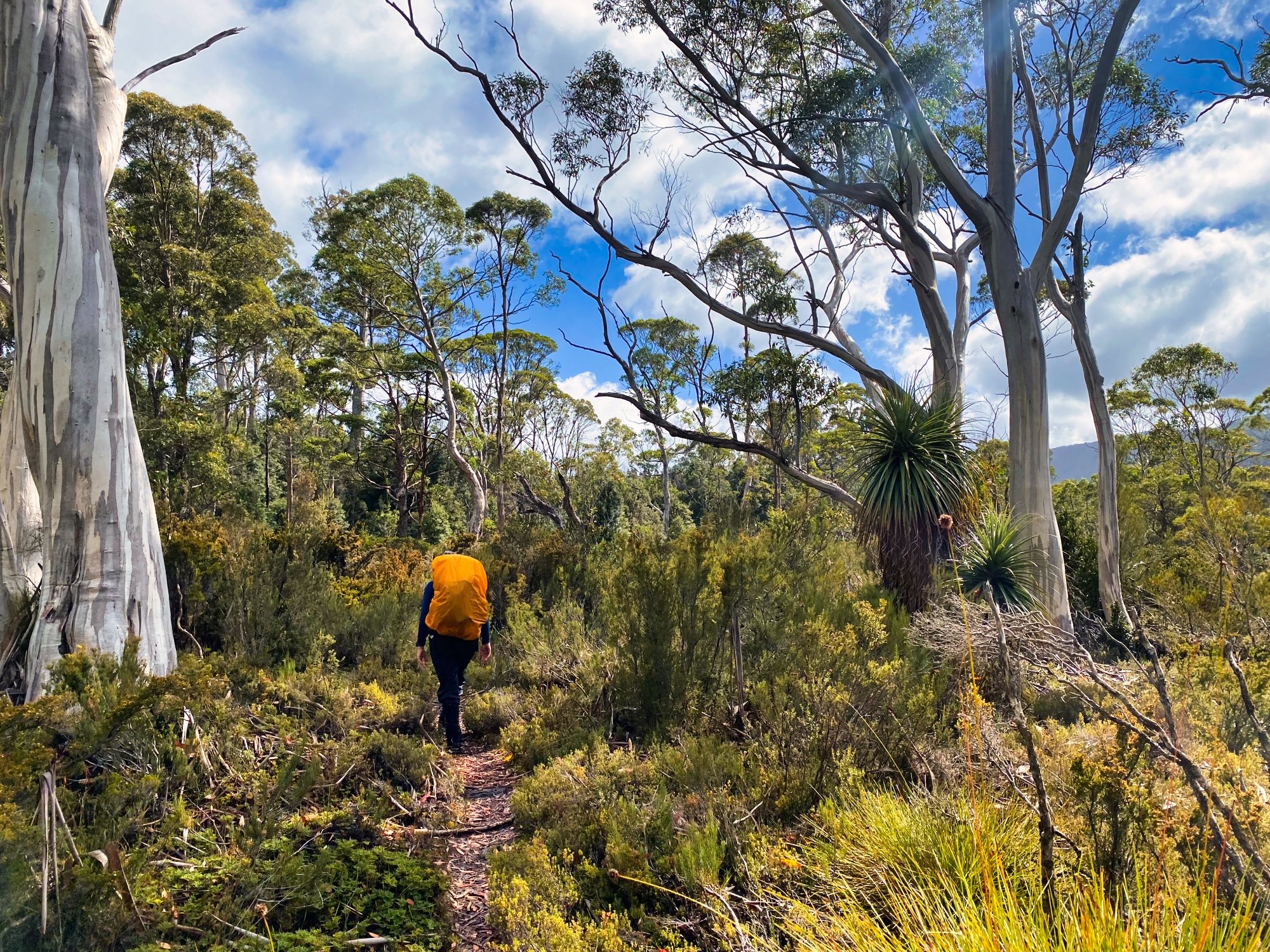
Initially the track is obvious and well marked.
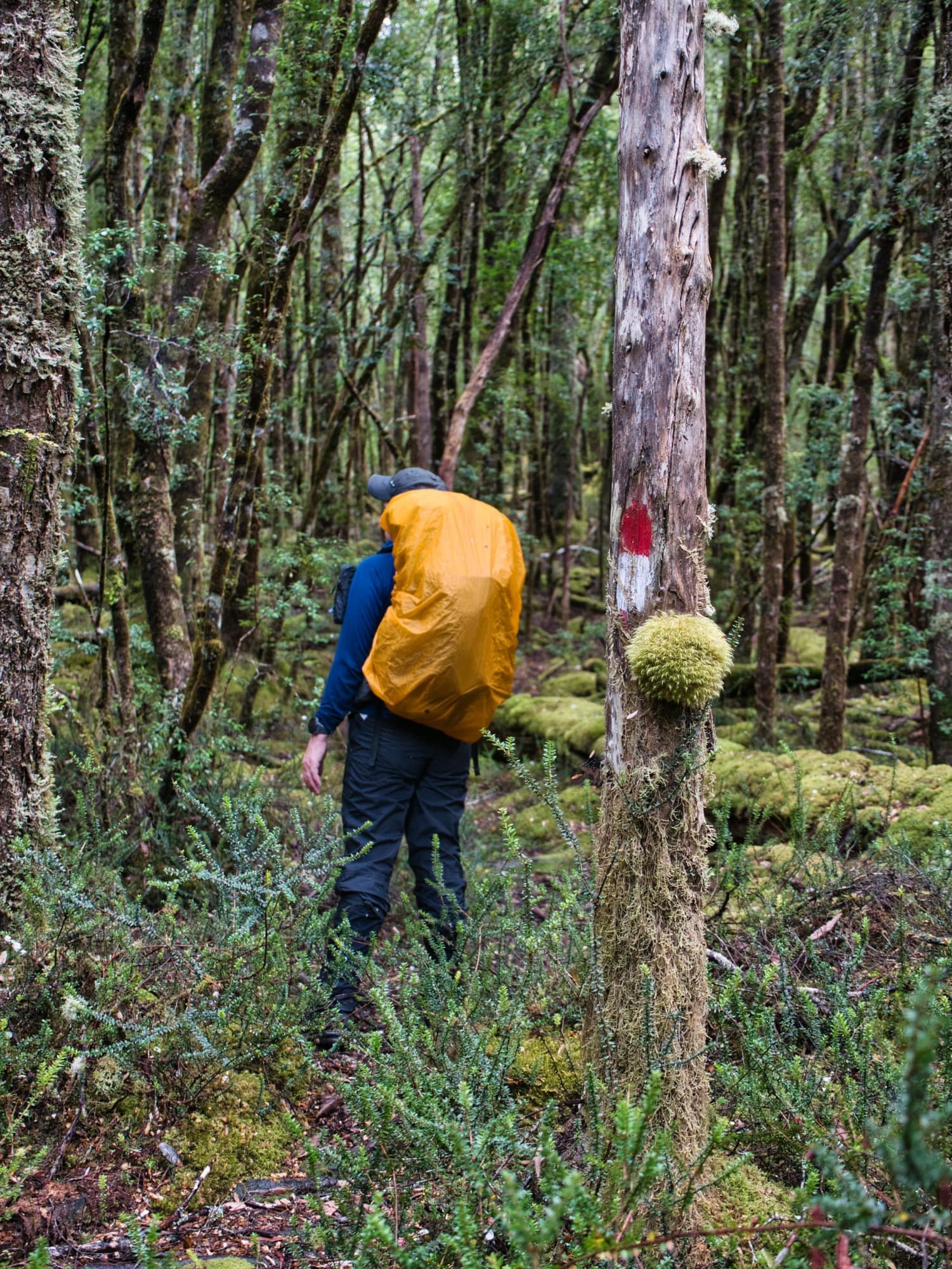
On the Lake Marion Track - the occasional old paint marker.
After the Mount Gould/Lake Marion (Nichols) junction, it became obvious that the remaining section of Lake Marion Track gets no love from PWS these days! The combination of beautiful open myrtle rainforest, combined with plenty of tree falls over the route, and seemingly minimal recent foot traffic meant the pad was often indistinct and easy to lose. The route is marked with a variety of old style markers, often well spaced out; a few times we needed to re-route back to the track, but nothing too difficult. Interestingly, the markers seemed much easier to locate on the return route. Along the route there were various small creek crossings over slimy boulders or wet timber to negotiate.

Out of the forest into the open button grass.
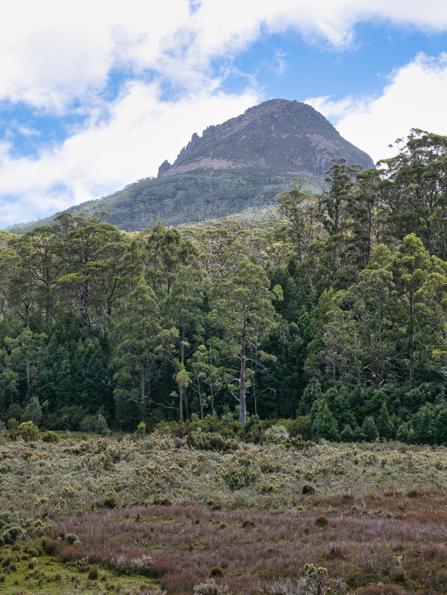
Mount Gould from the open button grass plains on The Lake Marion Track.
Not long before reaching Lake Marion, we broke out onto a lovely, open button grass plain below the Mount Gould Plateau. It was our first real views of the three mountains we would be visiting. They looked absolutely stunning from this vantage point; Horizontal Hill undeniably the smaller cousin of the other two with its neat heavily-vegetated slopes to the summit compared to Mount Gould’s and The Guardians towering cliffs of dolerite. We stopped briefly to chat to an echidna who was face-deep in an ant’s nest beside the track and then pushed onto the lake.

An Echidna on the track enjoying a feed of ants!

Horizontal Hill from the Lake Marion Track.

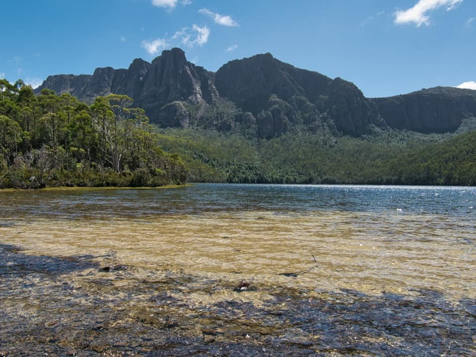
Mount Gould and The Guardians from Lake Marion.
Lake Marion was as divine as we expected. A bowl-like amphitheatre at the base of The Guardians and Mount Gould. Much to our surprise, the water was warm! Like bathwater warm! It was actually almost too warm to drink when we filled our water bottles. Not something we have experienced in alpine lakes before. Quickly pitching the tent in one of the few small cleared sites along its shore as we conscious of our weather window. The sun was trying to break through the again increasing layers of grey cloud, but there were views to be had from the top of Horizontal Hill! Best get up there!
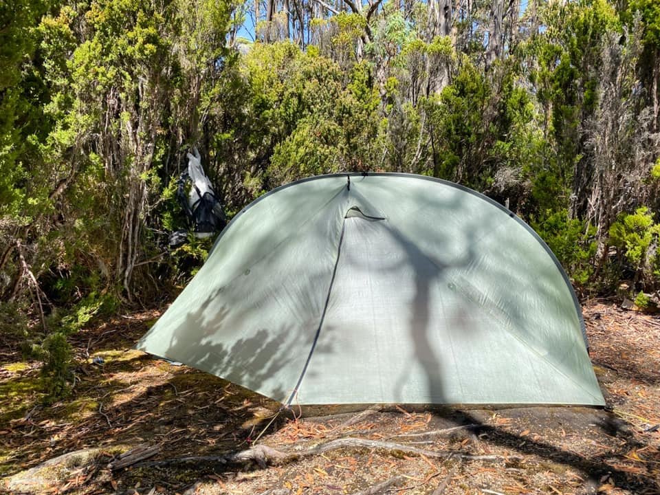
Out tent in one of the small camp sites on the edge of Lake Marion.
As we wound our way around the western shoreline of the lake, our feet stayed happily dry as the lake levels were quite low. After around 350m of wandering we noticed the change in vegetation that The Abels references and headed bush. We have, in the past, heard horror stories of hideous scrub, but we managed to pick our way up along the ridge and avoid almost all of the scrub by weaving through the mostly calf-high bauera and open tea-tree forest areas at all times sticking to the centre of the ridge. We chatted about how lucky we were with not encountering the thick scrub we had expected.

Avoiding the worst of the scrub on the way to the summit.

Very pleased that almost all of our walking was through this!
Baurea changed to open myrtle beech forest and the occasional Pandani grove before we broke out onto the minor plateau below the summit area. This would be the first time our views were not obstructed by forest cover - a compass bearing from the lake proves very helpful for navigation as once you leave the lake the summit is not again visible till very near the highest point!
From this vantage point we could see three minor challenges ahead. One, small cliffs we would need to navigate over or around. Two, dense scrub - including everyone’s favourite scoparia - and three, two more punchy climbs till the high point. With the sun now bright in the sky and in the lea of the cooling southerly, we were getting well and truly whacked by the heat.

Nearing the plateau below the summit.

No avoiding the denser scrub from the small plateau below the summit. (Note: We actually avoided all this on the return!)
A few pads lead through the scrub from this point forward but they would suddenly disappear into scoparia and we would find ourselves pushing through brief pockets of scrub. We’ve certainly pushed through worse but both of us were glad to reach the first rock ledge. Bender - with the benefit of height - climbed the ledge straight up, I travelled a few more metres and found a pad leading up to the same spot he was standing on so took that. The rock had rounded pockets in it like swiss cheese. Each small bowl held some beautiful fresh rain water and we drank from them using our collapsible cups. Delicious!

The final scrub push to the summit. This was avoided on our return journey.
A little more pushing, shoving, grunting, climbing and cussing at alpine vegetation (!) and we were summit bound within two hours from the lake, 5 hours in total from Narcissus. It was a much flatter and roomier summit area than it appeared from the lake below. We enjoyed wandering the entire summit, trying to figure out exactly where the highest point was (the map on Bender’s InReach was definitely wrong) and soaking in the 360-degree views. The Guardians looked as if we could almost reach out and touch them. We were both a bit bummed at this stage that we weren’t doing the traverse (or so we thought… see the Mount Gould/Guardians Essays!)
We sat a while enjoying a snack and the impressive mountains on display. It was great to see Mount Byron in summer as the last time I climbed it it was covered in snow and a total white-out. Mount Olympus’s massive bulk stood out as did the flat false summit of Mount Rufus. We could have stayed there all day drinking the cool water from the rock pools and enjoying the views but alas it was time to descend. Misty weather was approaching over The Eldons and West Coast Ranges, and we would much rather be safely tucked into our campsite at Lake Marion before the forecast storm hit.

The summit of Horizontal Hill with The Guardians rising behind me.

Mount Gould, The Guardians and Lake Marion from the summit of Horizontal Hill.
We had already scouted a better route down using our elevated view and were determined to avoid the scoparia we’d encountered on the way up. With our newly formed knowledge we stuck more to the south as soon as we dropped off the summit and managed to avoid all the scoparia and scrub! Yippee!
Back under the forest cover we headed down towards the lake, once again avoiding almost all the scrub with a weaving technique. With gravity assisting our descent we were very pleased to find ourselves back at camp in a little over an hour.
It was time for a swim and an early dinner, before battening down the hatches to ride out the predicted storm that evening. Neither of us got much sleep that night, with persistent rain and ferocious winds roaring overhead all night. Thankfully our little nook in the trees and scrub at the lake afforded us some protection from the storm which raged on until about noon the following day. It was only then we would pack up and begin our Mount Gould and The Guardians adventure - and what an adventure that turned out to be!
Time for a swim before retiring for the next days adventures.
The Stats.
Distance: Approximately 12km from Narcissus Hut to the summit and returning to Lake Marion..
Time taken: Just under 5 hrs from Narcissus Hut to the summit and then just over one hour to return to the lake from the summit..
Difficulty: The Abels book route is classified as hard due to the lack of any formal track from Lake Marion to the summit. Good navigational skills are required as line of sight of the mountain is completely obscured until near the summit area itself.
Type of track: Untracked from Lake Marion to the summit.
Access from: Lake Marion (or by traversing The Guardians).

The Map.
From Narcissus Hut to the summit of Horizontal Hill and returning to Lake Marion camp.